- Oregon Islands National Wildlife Refuge
-
Oregon Islands National Wildlife Refuge IUCN Category IV (Habitat/Species Management Area)
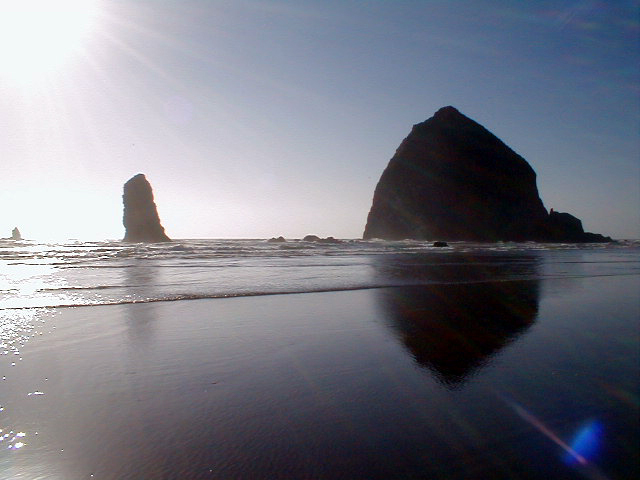
Haystack Rock at Cannon BeachLocation Oregon Coordinates 44°10′59″N 124°07′19″W / 44.1831763°N 124.1220644°WCoordinates: 44°10′59″N 124°07′19″W / 44.1831763°N 124.1220644°W[1] Area 1,083 acres (438 ha) [2] Governing body United States Fish and Wildlife Service Oregon Islands National Wildlife Refuge is a U.S. National Wildlife Refuge off the southwestern Oregon Coast. It is one of six National Wildlife Refuges comprising the Oregon Coast National Wildlife Refuge Complex. The Oregon Islands provides wilderness protection to 1,853 small islands, rocks, and reefs plus two headlands, totaling 371 acres (150 ha) spanning 1,083 acres (438 ha) [2] of Oregon's coastline from the Oregon–California border to Tillamook Head. There are sites in six of the seven coastal counties of Oregon. From north to south they are Clatsop, Tillamook, Lincoln, Lane, Coos, and Curry counties. (Douglas County is the only coastal Oregon county not included in the refuge.)
Contents
History
The Oregon Islands National Wildlife Refuge was created in 1935 by the federal government.[3] Haystack Rock off Cannon Beach was added to the refuge in 1968, and then became a wilderness area in 1978.[4] The first mainland addition to the refuge came in 1991 when Coquille Point near Bandon was added.[5] In 1999, the shipwreck of the New Carissa near Coos Bay spilled oil that killed some birds at the refuge.[6]
Wildlife and access
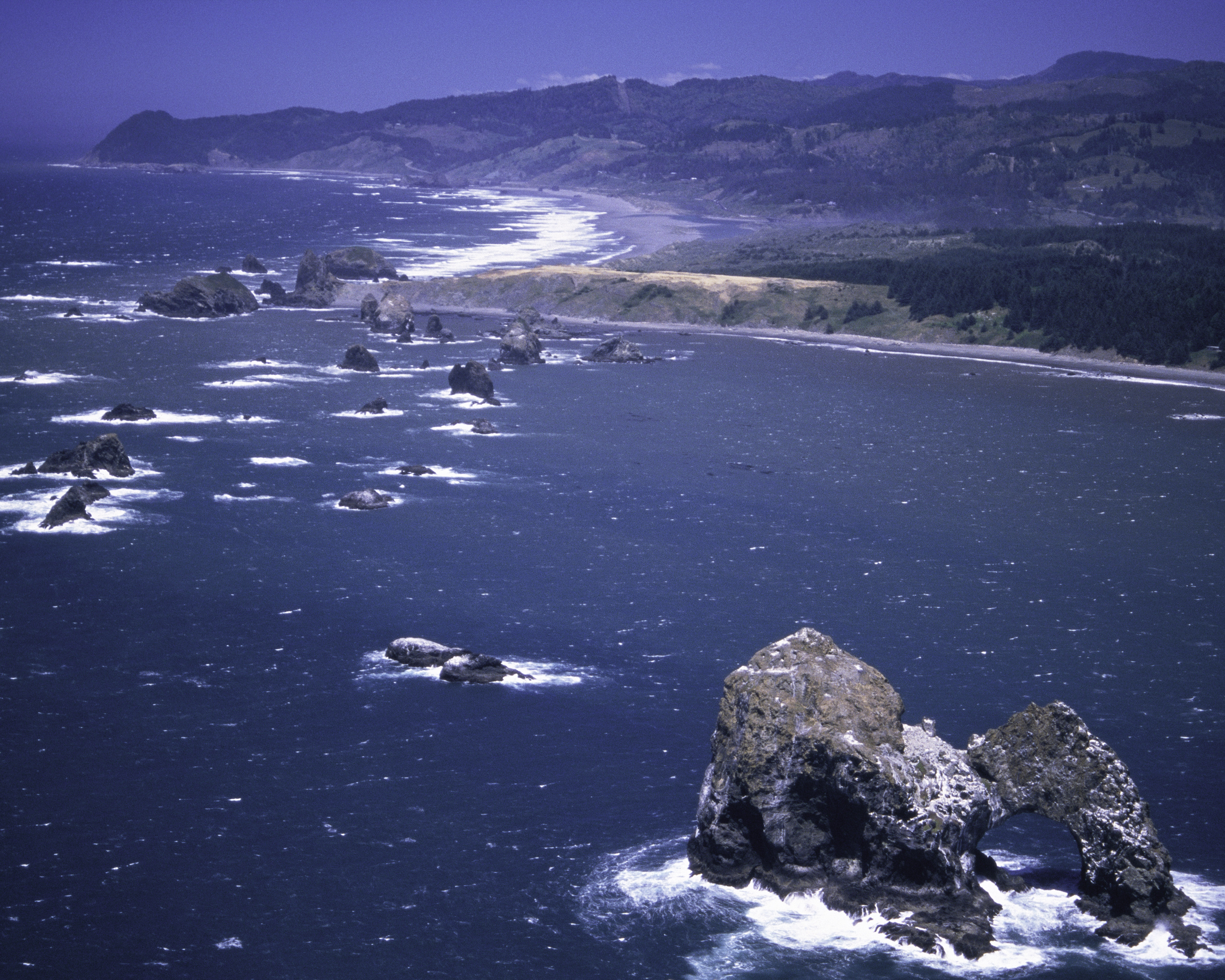
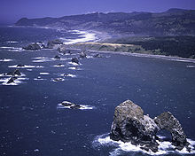 View from the south
It is a sanctuary for nesting seabirds of thirteen species—some of the most important nesting seabird colonies in the U.S. Over 1.2 million individuals nest in colonies here, more than on the California and Washington coasts combined.[3][6][7] The most prevalent species are black-and-white common Murres, Tufted Puffins, Rhinoceros and Cassin's Auklets, Pigeon Guillemots, Leach's Storm-petrels, several species of Gulls, and Caspian Terns.[8]
Four species of pinniped breed, molt, and rest on these lands, including harbor seals, Steller and California Sea Lions.[7][9] The southern portion of the refuge provides the greatest number of breeding and pupping sites for Steller sea lions in the U.S. outside Alaska.[8]
Except for Tillamook Rock Light and its surrounding 1-acre (4,000 m2) rock, all the islands are closed to public access. Boats must remain at least 500 feet (150 m) away,[10] and aircraft must maintain at least 2,000 ft (600 m) clearance.[9][11] However, good viewing is possible from Coquille Point in Bandon and other locations suggested by the Oregon Coast Birding Trail.[7]
The area is managed by the United States Fish and Wildlife Service.[8]
See also
- Pacific Flyway
- Important Bird Area
- List of National Wildlife Refuges in Oregon
- List of Oregon Wildernesses
- Wilderness Act
- List of U.S. Wilderness Areas
References
- ^ "Oregon Islands National Wildlife Refuge". Geographic Names Information System, U.S. Geological Survey. http://geonames.usgs.gov/pls/gnispublic/f?p=gnispq:3:::NO::P3_FID:1161465.
- ^ a b "Annual Report of Lands as of September 30, 2009". U.S. Fish and Wildlife Service. http://www.fws.gov/refuges/realty/archives/pdf/2009_Annual_Report_of_Lands.pdf.
- ^ a b "Oregon Coast National Wildlife Refuges" (PDF). United States Fish and Wildlife Service. October 12, 2000. pp. 6. http://library.fws.gov/Refuges/oregoncoast00.pdf. Retrieved 2007-09-14.
- ^ Tobias, Lori (May 18, 2007). "Local guardians of Haystack Rock look for backup". The Oregonian.
- ^ Henderson, Bonnie (July 1992). "The wild worlds of the Oregon coast". Sunset. http://findarticles.com/p/articles/mi_m1216/is_n1_v189/ai_12668355. Retrieved 2007-09-18.
- ^ a b Hill, Richard L. (March 14, 1999). "Spill has no mercy on Oregon seabirds". The Oregonian.
- ^ a b c "Oregon Islands National Wildlife Refuge". United States Fish and Wildlife Service. http://www.fws.gov/oregoncoast/oregonislands/index.htm. Retrieved 2007-09-14.
- ^ a b c "Oregon Islands Wilderness". Wilderness.net. http://www.wilderness.net/index.cfm?fuse=NWPS&sec=wildView&wname=Oregon%20Islands%20Wilderness. Retrieved 2007-09-14.
- ^ a b "Welcome to the Oregon Coast National Wildlife Refuge Complex Home Page!". United States Fish and Wildlife Service. http://www.fws.gov/oregoncoast/index.htm. Retrieved 2007-09-14.
- ^ "Help Protect Marine Wildlife" (PDF). United States Fish and Wildlife Service. http://www.fws.gov/oregoncoast/PDF/Boat%20Poster.pdf. Retrieved 2007-09-14.
- ^ "Pilots: Please Help Protect Marine Wildlife in Oregon" (PDF). United States Fish and Wildlife Service. http://www.fws.gov/oregoncoast/PDF/Pilots%20Poster%20FINAL.pdf. Retrieved 2007-09-14.
Protected Areas of Oregon Federal State Arcadia Beach • Bob Straub • Bradley • Cape Kiwanda • Cape Lookout • Cape Meares • Clay Myers at Whalen Island • Del Rey Beach • Ecola • Elmer Feldenheimer • Fishing Rock • Fort Stevens • Gearhart Ocean • Haystack Hill • Hug Point • John Yeon • Manhattan Beach • Munson Creek Falls • Neahkahnie–Manzanita • Nehalem Bay • Oceanside Beach • Oswald West • Rockaway Beach • Sunset Beach • Sunset Highway Forest • Symons • Tolovana Beach • Tolovana Beach • Twin Rocks • Wilson River Highway Forest
Agate Beach • Alsea Bay • Beachside • Beaver Creek • Beverly Beach • Boiler Bay • Carl G. Washburne • Collins Creek • D River • Darlingtonia • Devils Lake • Devils Punch Bowl • Driftwood Beach • Ellmaker • Fogarty Creek • Gleneden Beach • Governor Patterson • H.B. Van Duzer • Heceta Head Lighthouse • Jessie M. Honeyman • Joaquin Miller Forest • L. Presley & Vera C. Gill • Lost Creek • Muriel O. Ponsler • Neptune • Neskowin Beach • Ona Beach • Otter Crest • Pritchard • Roads End • Rocky Creek • San Marine • Seal Rock • Smelt Sands • South Beach • Stonefield Beach • Tokatee Klootchman • W. B. Nelson • Whale Watching • Yachats • Yachats Ocean Road • Yaquina Bay
Albert H. Powers • Alfred A. Loeb • Arizona Beach • Bandon • Bolon Island Tideways • Bullards Beach • Cape Arago • Cape Blanco • Cape Sebastian • Conde B. McCullough • Coquille Myrtle Grove • Crissey Field • Elk Creek Tunnel Forest • Face Rock • Floras Lake • Geisel Monument • Golden and Silver Falls • Harris Beach • Hoffman • Humbug Mountain • Hutchinson • Maria C. Jackson • McVay Rock • Ophir • Otter Point • Paradise Point • Pistol River • Port Orford Cedar Forest • Port Orford Heads • Samuel H. Boardman • Seven Devils • Shore Acres • Sisters Rock • Sunset Bay • Sweet Myrtle • Umpqua • Umpqua Lighthouse • Umpqua Myrtle • William M. Tugman • Winchuck • Yoakam Point
Banks–Vernonia • Bonnie Lure • Government Island • L. L. "Stub" Stewart • Mary S. Young • Milo McIver • Tryon Creek • Willamette Stone
Ainsworth • Benson • Bonneville • Bridal Veil Falls • Crown Point • Dabney • Dalton Point • George W. Joseph • Guy W. Talbot • Historic Columbia River Highway • John B. Yeon • Koberg Beach • Lang Forest • Lewis and Clark • Lindsey Creek • Mayer • McLoughlin • Memaloose • Multnomah Falls • Portland Women's Forum • Rocky Butte • Rooster Rock • Seneca Fouts • Shepperd's Dell • Sheridan • Starvation Creek • Viento • Vinzenz Lausmann • Wyeth • Wygant
Alderwood • Bald Peak • Blachly Mountain Forest • Bowers Rock • Cascadia • Champoeg • Detroit Lake • Dexter • Elijah Bristow • Erratic Rock • Fall Creek • Fort Yamhill • Holman • Jasper • Lowell • Luckiamute • Maples • Maud Williamson • Molalla River • North Santiam • Sarah Helmick • Silver Falls • State Capitol • Thompson's Mills • Washburne • Willamette Mission
Ben Hur Lampman • Canyon Creek Forest • Casey • Collier Memorial • Illinois River Forks • Jackson F. Kimball • Joseph H. Stewart • Klamath Falls – Lakeview Forest • OC&E Woods Line • Prospect • Rough and Ready Forest • Stage Coach Forest • TouVelle • Tub Springs • Valley of the Rogue • Wolf Creek Inn
Cline Falls • Deschutes River • Dyer • Elliott Corbett • La Pine • Ochoco • Peter Skene Ogden • Pilot Butte • Prineville Reservoir • Redmond–Bend Juniper • Sisters • Smith Rock • The Cove Palisades • Tumalo • White River Falls
Bates • Battle Mountain Forest • Blue Mountain Forest • Booth • Catherine Creek • Chandler • Clyde Holliday • Crooked Creek • Deadman's Pass • Emigrant Springs • Farewell Bend • Fort Rock • Fort Rock Cave • Frenchglen Hotel • Goose Lake • Hat Rock • Hilgard Junction • Kam Wah Chung • Lake Owyhee • Minam • Ontario • Pete French Round Barn • Red Bridge • Succor Creek • Sumpter Valley Dredge • Ukiah–Dale Forest • Unity Forest • Unity Lake • Wallowa Lake • Wallowa Lake Highway Forest • Wallowa River
Bridge Creek • Dean Creek • Denman • E.E. Wilson • Elkhorn • Fern Ridge • Irrigon • Jewell Meadows • Klamath • Ladd Marsh • Lower Deschutes • Phillip W. Schneider • Prineville • Riverside • Sauvie Island • Snake River Islands • Summer Lake • Wenaha • White River • Willow Creek
Regions Portland metroBlue Lake • Cooper Mountain • Glendoveer • Howell • Oregon Zoo • Oxbow • Smith and Bybee • Mount Talbert
Cities PortlandForest Park • Washington Park
Heritage registers: National Register of Historic Places • National Historic Landmarks • National Natural Landmarks • World Network of Biosphere Reserves Categories:- IUCN Category IV
- Protected areas of Clatsop County, Oregon
- Protected areas of Coos County, Oregon
- Protected areas of Curry County, Oregon
- Protected areas of Lane County, Oregon
- Protected areas of Lincoln County, Oregon
- Protected areas of Tillamook County, Oregon
- National Wildlife Refuges in Oregon
- Wilderness Areas of Oregon
- Oregon Coast
- Islands of Oregon
Wikimedia Foundation. 2010.