- Kalmiopsis Wilderness
Infobox_protected_area | name = Kalmiopsis Wilderness
iucn_category = Ib
caption =
locator_x =
locator_y =
location =Oregon ,USA
nearest_city =Cave Junction, Oregon
lat_degrees = 42
lat_minutes = 16
lat_seconds = 57
lat_direction = N
long_degrees = 123
long_minutes = 57
long_seconds = 48
long_direction = W
area = convert|179755|acre|km2|1|sing=off
established =1964
governing_body =United States Forest Service Kalmiopsis Wilderness is a
wilderness area in theKlamath Mountains of southwesternOregon , within theRogue River-Siskiyou National Forest . It was designated wilderness by theUnited States Congress in 1964 and now comprises a total of convert|179755|acre|km2|1|sing=off. [http://www.fs.fed.us/r6/rogue-siskiyou/recreation/wilderness/kalmiopsis.shtml Kalmiopsis Wilderness] - Rogue River-Siskiyou National Forest] There are approximately 153 miles of trails on 24 established hiking trails in the area. [ [http://gorp.away.com/gorp/resource/us_wilderness_area/or_kalmi.htm Kalmiopsis Wilderness, Oregon] - GORP]The Kalmiopsis Wilderness was named for "
Kalmiopsis leachiana ", a slow-growing plant related to therhododendron , which was discovered in the area in 1930. [cite book
last = McArthur
first = Lewis A.
authorlink =
coauthors = Lewis L. McArthur
title = Oregon Geographic Names
origyear = 1928
edition = Seventh Edition
year = 2003
publisher =Oregon Historical Society Press
location = Portland,Oregon
id = ISBN 0-87595-277-1 (trade paperback), ISBN 0-87595-278-X (hardcover) ]Topography
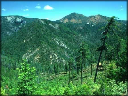
Elevations in Kalmiopsis Wilderness range from convert|500|ft|m|1|sing=off to convert|5098|ft|m|1|sing=off feet, at Pearsoll Peak. The area is characterized by deep, rough canyons, sharp rock ridges, and clear rushing mountain streams and rivers, including the headwater basins of the Chetco, North Fork Smith Rivers, as well as part of the Illinois River canyon. All three of these rivers have been designated Wild and Scenic.
Geology
The Kalmiopsis Wilderness is part of the Klamath Mountain geologic province of northwestern California and southwestern Oregon. The eastern half is part of the Josephine "ultramafic" sheet, meaning it has a very high
iron andmagnesium content. The western half of the Wilderness is underlain by the sedimentary rocks of the Dothan formation and by the igneous intrusive rocks of the Big Craggies. Most of the rocks in this province were formerly parts of the oceanic crust and includedserpentine , submarine volcanic flow rocks, intrusive granite-like rocks, and sedimentary rocks such asshale andsandstone . [http://www.wilderness.net/index.cfm?fuse=NWPS&sec=wildView&wname=Kalmiopsis%20Wilderness&error=404 Kalmiopsis Wilderness] - Wilderness.net] Historic mine sites forgold andchromite can still be found in the form of cabin sites, mines, and ditches.Vegetation
Diversity of topography and geology provide excellent habitat for a wide variety of botanical species. The "
Kalmiopsis leachiana " plant was discovered in 1930 by Lilla Leech in the Gold Basin area. The plant is a relic of the pre-ice age and the oldest member of the "Ericaceae" Family, and is the namesake of the Kalmiopsis Wilderness. In 2002 the nearly convert|500000|acre|km2|1|sing=onBiscuit Fire burned the entire wilderness area. The environment has changed dramatically and provides a unique opportunity to observe a natural response to fire disturbance through plant succession, erosional and depositional occurrences and changed habitat for flora and fauna.Gallery
References
See also
*
List of Oregon Wildernesses
*List of U.S. Wilderness Areas
*Wilderness Act External links
* [http://www.fs.fed.us/r6/rogue-siskiyou/recreation/wilderness/kalmiopsis.shtml Rogue River-Siskiyou National Forest - Kalmiopsis Wilderness]
* [http://www.wilderness.org/Library/Documents/WildfireSummary_Biscuit.cfm Summary of Biscuit Complex Fire] - Wilderness Society
* [http://www.npr.org/templates/story/story.php?storyId=1344180 National Public Radio] - Audio story after the Biscuit Fire.
Wikimedia Foundation. 2010.