- Diamond Peak Wilderness
-
For other uses of "Diamond Peak", see Diamond Peak (disambiguation).
Diamond Peak Wilderness IUCN Category Ib (Wilderness Area)

Location Klamath / Lane counties, Oregon, USA Nearest city Oakridge, Oregon Coordinates 43°31′0″N 122°9′0″W / 43.516667°N 122.15°WCoordinates: 43°31′0″N 122°9′0″W / 43.516667°N 122.15°W Area 52,337 acres (21,180 ha) Established 1964 Governing body U.S. Forest Service The Diamond Peak Wilderness is a wilderness area straddling the Cascade crest and includes the Diamond Peak Volcano. It is located within two National Forests - the Willamette National Forest on the west and the Deschutes National Forest on the east.[1]
Contents
Designation
On February 5, 1957, the Forest Service established the 36,637-acre (14,826 ha) Diamond Peak Wild Area. Upon passage of the federal Wilderness Act in 1964 it was reclassified as wilderness. With the passage of the Oregon Wilderness Act of 1984, Diamond Peak Wilderness increased in size to its present 52,337 acres (21,180 ha)[2]
Geography
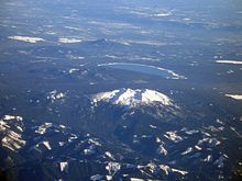 Diamond Peak and Crescent Lake from the west.
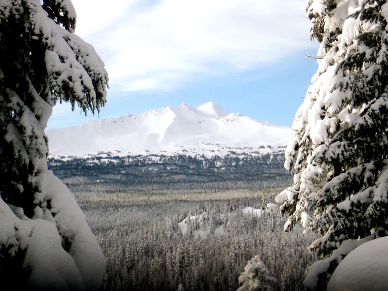
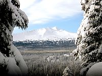 Diamond Peak from the Pacific Crest Trail
At 8,744 feet (2,665 m), Diamond Peak is the most prominent peak in the Wilderness, followed by Mount Yoran at 7,138 feet (2,176 m) and Lakeview Mountain at 7,057 feet (2,151 m).[2] Diamond Peak is a shield volcano formed as the entire Cascades mountain range was undergoing volcanic activity and uplift. Glaciers carved the large volcanic peak and when they receded, the bulk of the mountain remained, with snowfields near the summit and dozens of small lakes surrounding the peak. These lakes range from one to 28 acres (11 ha) in size.[1] Approximately 14 miles (23 km) of the Pacific Crest National Scenic Trail pass through this wilderness. Another 38 miles (61 km) of trail, including the 10-mile (16 km) Diamond Peak Trail, stretches the length of the west side of the peak.[1]
Vegetation
Nearly the entire Diamond Peak Wilderness area is covered with mixed stands of mountain hemlock, lodgepole and western white pine, and silver, noble and other true firs.[1] Alpine flowers, including varieties of mimulus, trillium, lupine, penstemon, heather, and Indian paintbrush, are common along trails, lake shores, streams and in the meadows. Huckleberry and dwarf manzanita are common in the dense underbrush.[2][3]
Wildlife
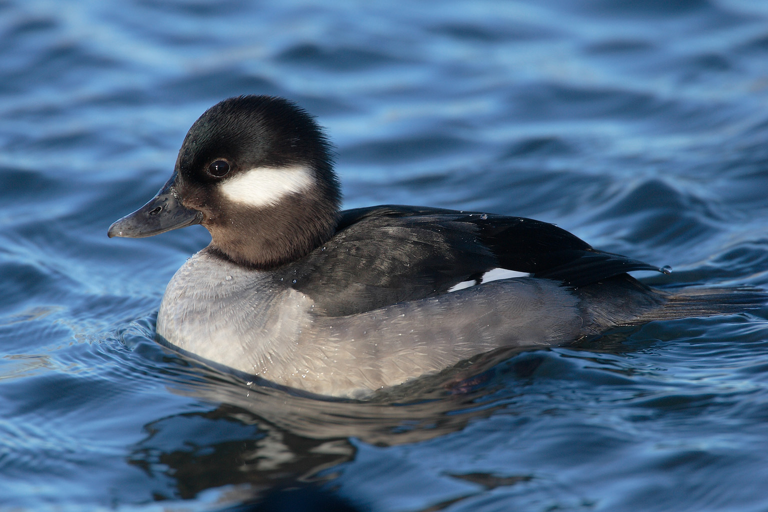
 Bufflehead (Bucephala albeola)
Diamond Peak Wilderness is home to black-tailed deer, mule deer, and elk. In winter, the mule deer migrate eastward out of the Wilderness to the sage desert, while black-tailed deer and elk drop down the west slope. Black bear and small mammals including marmots, snowshoe rabbits, squirrels, pine martens, foxes, pikas, and conies inhabit the area all year long. The raven, Clark's nutcracker, Oregon jay, and water ouzel frequent the forest and streams year-round. Bufflehead and goldeneye ducks occasionally nest near the lakes.[2][3]
Recreation
Recreational activities in the Diamond Peak Wilderness include hiking, horseback riding, camping, hunting, fishing, and mountain climbing. Some 125 miles (200 km) of trails cross the Wilderness, including 14 miles (23 km) the Pacific Crest Trail along the east slope of Diamond Peak. Marie Lake, Divide Lake, and Rockpile Lake are popular base camps for the climb up Diamond Peak. Mount Yoran and Lakeview Mountain can also be climbed. Winter is popular for snowshoeing and cross-country skiing.[1][2]
See also
References
External links
- Willamette National Forest - Diamond Peak Wilderness
- Deschutes & Ochoco National Forests - Diamond Peak Wilderness
- USGS Cascades Volcano Observatory - Diamond Peak
- Willamette National Forest - Diamond Peak Trail Area
Protected Areas of Oregon Federal State Arcadia Beach • Bob Straub • Bradley • Cape Kiwanda • Cape Lookout • Cape Meares • Clay Myers at Whalen Island • Del Rey Beach • Ecola • Elmer Feldenheimer • Fishing Rock • Fort Stevens • Gearhart Ocean • Haystack Hill • Hug Point • John Yeon • Manhattan Beach • Munson Creek Falls • Neahkahnie–Manzanita • Nehalem Bay • Oceanside Beach • Oswald West • Rockaway Beach • Sunset Beach • Sunset Highway Forest • Symons • Tolovana Beach • Tolovana Beach • Twin Rocks • Wilson River Highway Forest
Agate Beach • Alsea Bay • Beachside • Beaver Creek • Beverly Beach • Boiler Bay • Carl G. Washburne • Collins Creek • D River • Darlingtonia • Devils Lake • Devils Punch Bowl • Driftwood Beach • Ellmaker • Fogarty Creek • Gleneden Beach • Governor Patterson • H.B. Van Duzer • Heceta Head Lighthouse • Jessie M. Honeyman • Joaquin Miller Forest • L. Presley & Vera C. Gill • Lost Creek • Muriel O. Ponsler • Neptune • Neskowin Beach • Ona Beach • Otter Crest • Pritchard • Roads End • Rocky Creek • San Marine • Seal Rock • Smelt Sands • South Beach • Stonefield Beach • Tokatee Klootchman • W. B. Nelson • Whale Watching • Yachats • Yachats Ocean Road • Yaquina Bay
Albert H. Powers • Alfred A. Loeb • Arizona Beach • Bandon • Bolon Island Tideways • Bullards Beach • Cape Arago • Cape Blanco • Cape Sebastian • Conde B. McCullough • Coquille Myrtle Grove • Crissey Field • Elk Creek Tunnel Forest • Face Rock • Floras Lake • Geisel Monument • Golden and Silver Falls • Harris Beach • Hoffman • Humbug Mountain • Hutchinson • Maria C. Jackson • McVay Rock • Ophir • Otter Point • Paradise Point • Pistol River • Port Orford Cedar Forest • Port Orford Heads • Samuel H. Boardman • Seven Devils • Shore Acres • Sisters Rock • Sunset Bay • Sweet Myrtle • Umpqua • Umpqua Lighthouse • Umpqua Myrtle • William M. Tugman • Winchuck • Yoakam Point
Banks–Vernonia • Bonnie Lure • Government Island • L. L. "Stub" Stewart • Mary S. Young • Milo McIver • Tryon Creek • Willamette Stone
Ainsworth • Benson • Bonneville • Bridal Veil Falls • Crown Point • Dabney • Dalton Point • George W. Joseph • Guy W. Talbot • Historic Columbia River Highway • John B. Yeon • Koberg Beach • Lang Forest • Lewis and Clark • Lindsey Creek • Mayer • McLoughlin • Memaloose • Multnomah Falls • Portland Women's Forum • Rocky Butte • Rooster Rock • Seneca Fouts • Shepperd's Dell • Sheridan • Starvation Creek • Viento • Vinzenz Lausmann • Wyeth • Wygant
Alderwood • Bald Peak • Blachly Mountain Forest • Bowers Rock • Cascadia • Champoeg • Detroit Lake • Dexter • Elijah Bristow • Erratic Rock • Fall Creek • Fort Yamhill • Holman • Jasper • Lowell • Luckiamute • Maples • Maud Williamson • Molalla River • North Santiam • Sarah Helmick • Silver Falls • State Capitol • Thompson's Mills • Washburne • Willamette Mission
Ben Hur Lampman • Canyon Creek Forest • Casey • Collier Memorial • Illinois River Forks • Jackson F. Kimball • Joseph H. Stewart • Klamath Falls – Lakeview Forest • OC&E Woods Line • Prospect • Rough and Ready Forest • Stage Coach Forest • TouVelle • Tub Springs • Valley of the Rogue • Wolf Creek Inn
Cline Falls • Deschutes River • Dyer • Elliott Corbett • La Pine • Ochoco • Peter Skene Ogden • Pilot Butte • Prineville Reservoir • Redmond–Bend Juniper • Sisters • Smith Rock • The Cove Palisades • Tumalo • White River Falls
Bates • Battle Mountain Forest • Blue Mountain Forest • Booth • Catherine Creek • Chandler • Clyde Holliday • Crooked Creek • Deadman's Pass • Emigrant Springs • Farewell Bend • Fort Rock • Fort Rock Cave • Frenchglen Hotel • Goose Lake • Hat Rock • Hilgard Junction • Kam Wah Chung • Lake Owyhee • Minam • Ontario • Pete French Round Barn • Red Bridge • Succor Creek • Sumpter Valley Dredge • Ukiah–Dale Forest • Unity Forest • Unity Lake • Wallowa Lake • Wallowa Lake Highway Forest • Wallowa River
Bridge Creek • Dean Creek • Denman • E.E. Wilson • Elkhorn • Fern Ridge • Irrigon • Jewell Meadows • Klamath • Ladd Marsh • Lower Deschutes • Phillip W. Schneider • Prineville • Riverside • Sauvie Island • Snake River Islands • Summer Lake • Wenaha • White River • Willow Creek
Regions Portland metroBlue Lake • Cooper Mountain • Glendoveer • Howell • Oregon Zoo • Oxbow • Smith and Bybee • Mount Talbert
Cities PortlandForest Park • Washington Park
Heritage registers: National Register of Historic Places • National Historic Landmarks • National Natural Landmarks • World Network of Biosphere Reserves Categories:- IUCN Category Ib
- Protected areas of Klamath County, Oregon
- Protected areas of Lane County, Oregon
- Wilderness Areas of Oregon
- Willamette National Forest
- Deschutes National Forest


Wikimedia Foundation. 2010.