- Prospect State Scenic Viewpoint
-
Prospect State Scenic Viewpoint 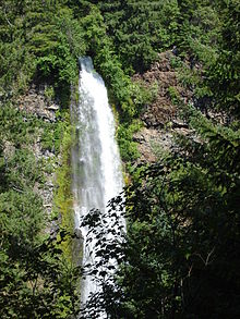
Mill Creek FallsLocation Prospect, Oregon Coordinates 42°44′16″N 122°29′43″W / 42.7378°N 122.4954°WCoordinates: 42°44′16″N 122°29′43″W / 42.7378°N 122.4954°W Type Segmented Total height 173 feet (53 m)[1] Number of drops 1 Prospect State Scenic Viewpoint, is a state park in the U.S. state of Oregon. It was formerly known as Mill Creek Falls Scenic Area, a private hiking area that was developed by Willamette Industries near the community of Prospect on Oregon Route 62 in Jackson County. Both Mill Creek Falls and Pearsony Falls are contained within the area, with Barr Creek Falls close by.[1]
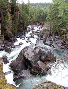
A hydroelectric dam was built in the 1920s which drained the narrow valley containing the group of falls. A group of large boulders appeared.[2] These have become a local attraction known as the Avenue of the Giant Boulders.
References
- ^ a b Phillips, Karen (2006-09-20). "Follow the road less traveled - to Prospect, Oregon". Mail Tribune. http://www.mailtribune.com/apps/pbcs.dll/article?AID=/20060920/JOY/70719024. Retrieved 2009-05-08.
- ^ Freeman, Mark (2008-11-03). "Going with the Flow". Mail Tribune. http://www.mailtribune.com/apps/pbcs.dll/article?AID=/20081103/NEWS/811030310. Retrieved 2009-05-08.
External links
 Avenue of the Giant Boulders
 Media related to Prospect State Scenic Viewpoint at Wikimedia Commons
- Prospect State Scenic Viewpoint official site from Oregon Parks and Recreation Department
- Mill Creek Falls at waterfallsnorthwest.com
- Barr Creek Falls at waterfallsnorthwest.com
- Waterfalls guide information
Waterfalls of Oregon Columbia Gorge - (west to east): Latourell Falls
- Bridal Veil Falls
- Coopey Falls
- Wahkeena Falls
- Fairy Falls
- Multnomah Falls
- Horsetail Falls
- Oneonta Gorge
- Wahclella Falls
- Camp Benson Falls
- Hole-in-the-Wall Falls
- Celilo Falls
- Eagle Creek
- (north to south): Wauna Falls
- Metlako Falls
- Lower Punch Bowl Falls
- Punch Bowl Falls
- Loowit Falls
- Skoonichuk Falls
- Tenas Falls
- Wy'east Falls
- Grand Union Falls
- Tunnel Falls
- Twister Falls
- Sevenmile Falls
Other areas - NW Oregon: Youngs River Falls
- Ki-a-Kuts Falls
- Willamette Valley: Willamette Falls
- Silver Falls State Park
- Shellburg Falls
- Salt Creek Falls
- Southern Cascades: Toketee Falls
- Watson Falls
- Mill Creek Falls
- Central Oregon: Benham Falls
- Dillon Falls
- Lava Island Falls
Protected Areas of Oregon Federal State Arcadia Beach • Bob Straub • Bradley • Cape Kiwanda • Cape Lookout • Cape Meares • Clay Myers at Whalen Island • Del Rey Beach • Ecola • Elmer Feldenheimer • Fishing Rock • Fort Stevens • Gearhart Ocean • Haystack Hill • Hug Point • John Yeon • Manhattan Beach • Munson Creek Falls • Neahkahnie–Manzanita • Nehalem Bay • Oceanside Beach • Oswald West • Rockaway Beach • Sunset Beach • Sunset Highway Forest • Symons • Tolovana Beach • Tolovana Beach • Twin Rocks • Wilson River Highway Forest
Agate Beach • Alsea Bay • Beachside • Beaver Creek • Beverly Beach • Boiler Bay • Carl G. Washburne • Collins Creek • D River • Darlingtonia • Devils Lake • Devils Punch Bowl • Driftwood Beach • Ellmaker • Fogarty Creek • Gleneden Beach • Governor Patterson • H.B. Van Duzer • Heceta Head Lighthouse • Jessie M. Honeyman • Joaquin Miller Forest • L. Presley & Vera C. Gill • Lost Creek • Muriel O. Ponsler • Neptune • Neskowin Beach • Ona Beach • Otter Crest • Pritchard • Roads End • Rocky Creek • San Marine • Seal Rock • Smelt Sands • South Beach • Stonefield Beach • Tokatee Klootchman • W. B. Nelson • Whale Watching • Yachats • Yachats Ocean Road • Yaquina Bay
Albert H. Powers • Alfred A. Loeb • Arizona Beach • Bandon • Bolon Island Tideways • Bullards Beach • Cape Arago • Cape Blanco • Cape Sebastian • Conde B. McCullough • Coquille Myrtle Grove • Crissey Field • Elk Creek Tunnel Forest • Face Rock • Floras Lake • Geisel Monument • Golden and Silver Falls • Harris Beach • Hoffman • Humbug Mountain • Hutchinson • Maria C. Jackson • McVay Rock • Ophir • Otter Point • Paradise Point • Pistol River • Port Orford Cedar Forest • Port Orford Heads • Samuel H. Boardman • Seven Devils • Shore Acres • Sisters Rock • Sunset Bay • Sweet Myrtle • Umpqua • Umpqua Lighthouse • Umpqua Myrtle • William M. Tugman • Winchuck • Yoakam Point
Banks–Vernonia • Bonnie Lure • Government Island • L. L. "Stub" Stewart • Mary S. Young • Milo McIver • Tryon Creek • Willamette Stone
Ainsworth • Benson • Bonneville • Bridal Veil Falls • Crown Point • Dabney • Dalton Point • George W. Joseph • Guy W. Talbot • Historic Columbia River Highway • John B. Yeon • Koberg Beach • Lang Forest • Lewis and Clark • Lindsey Creek • Mayer • McLoughlin • Memaloose • Multnomah Falls • Portland Women's Forum • Rocky Butte • Rooster Rock • Seneca Fouts • Shepperd's Dell • Sheridan • Starvation Creek • Viento • Vinzenz Lausmann • Wyeth • Wygant
Alderwood • Bald Peak • Blachly Mountain Forest • Bowers Rock • Cascadia • Champoeg • Detroit Lake • Dexter • Elijah Bristow • Erratic Rock • Fall Creek • Fort Yamhill • Holman • Jasper • Lowell • Luckiamute • Maples • Maud Williamson • Molalla River • North Santiam • Sarah Helmick • Silver Falls • State Capitol • Thompson's Mills • Washburne • Willamette Mission
Ben Hur Lampman • Canyon Creek Forest • Casey • Collier Memorial • Illinois River Forks • Jackson F. Kimball • Joseph H. Stewart • Klamath Falls – Lakeview Forest • OC&E Woods Line • Prospect • Rough and Ready Forest • Stage Coach Forest • TouVelle • Tub Springs • Valley of the Rogue • Wolf Creek Inn
Cline Falls • Deschutes River • Dyer • Elliott Corbett • La Pine • Ochoco • Peter Skene Ogden • Pilot Butte • Prineville Reservoir • Redmond–Bend Juniper • Sisters • Smith Rock • The Cove Palisades • Tumalo • White River Falls
Bates • Battle Mountain Forest • Blue Mountain Forest • Booth • Catherine Creek • Chandler • Clyde Holliday • Crooked Creek • Deadman's Pass • Emigrant Springs • Farewell Bend • Fort Rock • Fort Rock Cave • Frenchglen Hotel • Goose Lake • Hat Rock • Hilgard Junction • Kam Wah Chung • Lake Owyhee • Minam • Ontario • Pete French Round Barn • Red Bridge • Succor Creek • Sumpter Valley Dredge • Ukiah–Dale Forest • Unity Forest • Unity Lake • Wallowa Lake • Wallowa Lake Highway Forest • Wallowa River
Bridge Creek • Dean Creek • Denman • E.E. Wilson • Elkhorn • Fern Ridge • Irrigon • Jewell Meadows • Klamath • Ladd Marsh • Lower Deschutes • Phillip W. Schneider • Prineville • Riverside • Sauvie Island • Snake River Islands • Summer Lake • Wenaha • White River • Willow Creek
Regions Portland metroBlue Lake • Cooper Mountain • Glendoveer • Howell • Oregon Zoo • Oxbow • Smith and Bybee • Mount Talbert
Cities PortlandForest Park • Washington Park
Categories:- Waterfalls of Oregon
- Parks in Jackson County, Oregon
- Oregon state parks
- Oregon geography stubs


Wikimedia Foundation. 2010.