- Crater Lake National Park
-
Crater Lake National Park IUCN Category II (National Park)Location of Crater Lake in southwestern Oregon

Location southwestern Oregon, United States Nearest city Medford Coordinates 42°54′43″N 122°08′53″W / 42.91183°N 122.14807°WCoordinates: 42°54′43″N 122°08′53″W / 42.91183°N 122.14807°W Area 183,225 acres (74,149 ha)[1] Established May 22, 1902 Visitors 448,319 (in 2010)[2] Governing body National Park Service Crater Lake National Park is a United States National Park located in southern Oregon. Established in 1902, Crater Lake National Park is the sixth oldest national park in the United States and the only one in the state of Oregon.[3] The park encompasses the caldera of Crater Lake, a remnant of a destroyed volcano, Mount Mazama, and the surrounding hills and forests.
The lake is 1,949 feet (594 m) deep at its deepest point,[4] which makes it the deepest lake in the United States, the second deepest in North America and the ninth deepest in the world.[note 1] However, when comparing its average depth of 1,148 feet (350 m) to the average depth of other deep lakes, Crater Lake becomes the deepest in the Western Hemisphere and the third deepest in the world. The impressive average depth of this volcanic lake is due to the nearly symmetrical 4,000-foot (1,200 m) deep caldera formed 7,700 years ago during the violent climactic eruptions and subsequent collapse of Mount Mazama and the relatively moist climate that is typical of the crest of the Cascade Range.
The caldera rim ranges in elevation from 7,000 to 8,000 feet (2,100 to 2,400 m). The United States Geological Survey benchmarked elevation of the lake surface itself is 6,178 feet (1,883 m). This National Park encompasses 183,225 acres (286.29 sq mi; 741.49 km2).[1] Crater Lake has no streams flowing into or out of it. All water that enters the lake is eventually lost from evaporation or subsurface seepage. The lake's water commonly has a striking blue hue, and the lake is re-filled entirely from direct precipitation in the form of snow and rain.
Contents
Geology
For more details on this topic, see Mount Mazama. Relief map of the Crater Lake area
Volcanic activity in this area is fed by subduction off the coast of Oregon as the Juan de Fuca Plate slips below the North American Plate (see plate tectonics). Heat and compression generated by this movement has created a mountain chain topped by a series of volcanoes, which together are called the Cascade Range. The large volcanoes in the range are called the High Cascades. However, there are many other volcanoes in the range as well, most of which are much smaller.
About 400,000 years ago, Mount Mazama began its existence in much the same way as the other mountains of the High Cascades, as overlapping shield volcanoes. Over time, alternating layers of lava flows and pyroclastic flows built Mazama's overlapping cones until it reached about 11,000 feet (3,400 m) in height.
As the young stratovolcano grew, many smaller volcanoes and volcanic vents were built in the area of the park and just outside what are now the park's borders. Chief among these were cinder cones. Although the early examples are gone—cinder cones erode easily—there are at least 13 much younger cinder cones in the park, and at least another 11 or so outside its borders, that still retain their distinctive cinder cone appearance. There continues to be debate as to whether these minor volcanoes and vents were parasitic to Mazama's magma chamber and system or if they were related to background Oregon Cascade volcanism.
After a period of dormancy, Mazama became active again. Then, around 5700 BC, Mazama collapsed into itself during a tremendous volcanic eruption, losing 2,500 to 3,500 feet (760 to 1,100 m) in height. The eruption formed a large caldera that, depending on the prevailing climate, was filled in about 740 years, forming a beautiful lake with a deep blue hue, known today as Crater Lake.[5]
The eruptive period that decapitated Mazama also laid waste to much of the greater Crater Lake area and deposited ash as far east as the northwest corner of what is now Yellowstone National Park, as far south as central Nevada, and as far north as southern British Columbia. It produced more than 150 times as much ash as the May 18, 1980 eruption of Mount St. Helens.
This ash has since developed a soil type called andisol. Soils in Crater Lake National Park are brown, dark brown or dark grayish brown sandy loams or loamy sands which have plentiful cobbles, gravel and stones. They are slightly to moderately acidic and their drainage is somewhat excessive or excessive.
Climate
Snow is relatively rare at low elevations in western Oregon, but it is common at higher elevations, especially at Crater Lake. Measurements at park headquarters, 6,475 feet (1,974 m) above sea level, show that snow falls more often here than at any other long-term weather station in Oregon. Winter, which typically begins at the park in September and runs through June, includes an average of 98 days with measurable snowfall. Up to 37 inches (94 cm) of snow have fallen on the park in a single day (in 1937, 1951, and 1971), 313 inches (800 cm) in a month (January 1950), and 903 inches (2,290 cm) in a year (1950).[6]
Snow typically accumulates in the park to depths of 10 to 15 feet (3.0 to 4.6 m) by early spring. Most of the park's roads remain closed through late spring, and snow lingers into the summer. In July and August, snowfall is uncommon, and "one magnificent day typically follows another".[7]
January is the coldest month, when highs average about 35 °F (2 °C) and lows average about 18 °F (−8 °C).[8] August is the warmest month, with an average high of roughly 69 °F (21 °C) and an average low of about 40 °F (4 °C).[8] Between 1961 and 1990, the highest recorded temperature was 90 °F (32 °C), and the lowest was −21 °F (−29 °C).[9]. Annual precipitation averages about 66 inches (1,700 mm) a year.[10] December is the wettest, averaging about 11 inches (280 mm).[10]
Climate data for Crater Lake Month Jan Feb Mar Apr May Jun Jul Aug Sep Oct Nov Dec Year Average high °F (°C) 34.5
(1.4)35.2
(1.8)36.5
(2.5)41.7
(5.4)49.2
(9.6)58.1
(14.5)68.0
(20.0)68.5
(20.3)61.7
(16.5)52.0
(11.1)38.5
(3.6)34.4
(1.3)48.19
(9.00)Average low °F (°C) 17.5
(−8.1)17.9
(−7.8)18.1
(−7.7)21.1
(−6.1)27.0
(−2.8)33.8
(1.0)39.8
(4.3)40.2
(4.6)35.5
(1.9)30.1
(−1.1)22.5
(−5.3)18.3
(−7.6)26.82
(−2.88)Precipitation inches (mm) 9.66
(245.4)7.78
(197.6)8.09
(205.5)4.60
(116.8)3.01
(76.5)1.98
(50.3)0.68
(17.3)1.29
(32.8)2.38
(60.5)4.75
(120.7)10.56
(268.2)10.84
(275.3)65.62
(1,666.7)Snowfall inches (cm) 85.3
(216.7)73.2
(185.9)87.5
(222.3)43.0
(109.2)19.3
(49)4.0
(10.2)0.5
(1.3)0.2
(0.5)4.1
(10.4)21.3
(54.1)69.1
(175.5)84.0
(213.4)495.0
(1,257.3)Source: Taylor and Hannan, pp. 11, 24, 39–41 (Based on data from 1961 through 1990.) Park features
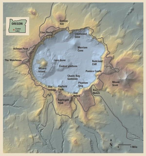
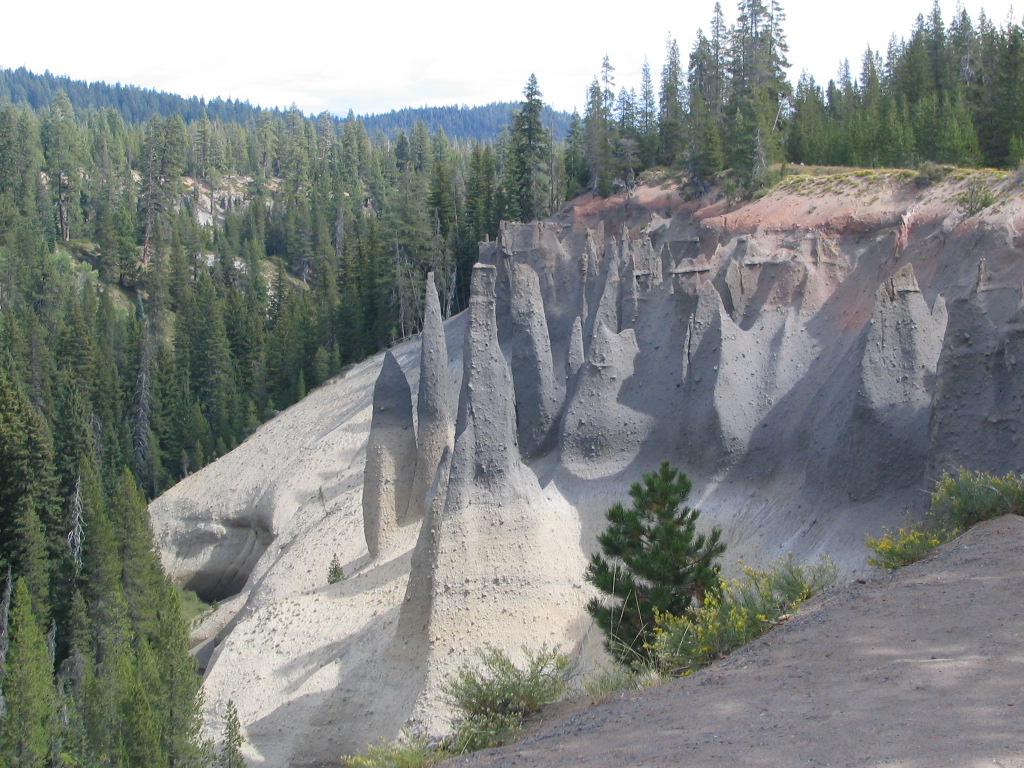
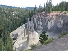 The Pinnacles
Some notable park features created by this huge eruption are:
- The Pumice Desert: A very thick layer of pumice and ash leading away from Mazama in a northerly direction. Even after thousands of years, this area is largely devoid of plants due to excessive porosity (meaning water drains through quickly) and poor soil composed primarily of regolith.
- The Pinnacles: When the very hot ash and pumice came to rest near the volcano, it formed 200-to-300-foot (60 to 90 m) thick gas-charged deposits. For perhaps years afterward, hot gas moved to the surface and slowly cemented ash and pumice together in channels and escaped through fumaroles. Erosion later removed most of the surrounding loose ash and pumice, leaving tall pinnacles and spires.
- Other park features
- Mount Scott is a steep andesitic cone whose lava came from magma from Mazama's magma chamber; geologists call such volcano a parasitic or satellite cone. Volcanic eruptions apparently ceased on Scott sometime before the end of the Pleistocene; one remaining large cirque on Scott's northwest side was left unmodified by post-ice age volcanism.
- In the southwest corner of the park stands Union Peak, an extinct volcano whose primary remains consist of a large volcanic plug, which is lava that solidified in the volcano's neck.
- Crater Peak is a shield volcano primarily made of andesite and basalt lava flows topped by andesitic and dacite tephra.
- Timber Crater is a shield volcano located in the northeast corner of the park. Like Crater Peak, it is made of basaltic and andesitic lava flows, but, unlike Crater, it is topped by two cinder cones.
- Rim Drive is the most popular road in the park; it follows a scenic route around the caldera rim.
- The Pacific Crest Trail, a 2,650-mile (4,260 km) long distance hiking and equestrian trail that stretches from the Mexican to Canadian borders, passes through the park.
- Old-growth forests covering 50,000 acres (20,000 ha).[11]
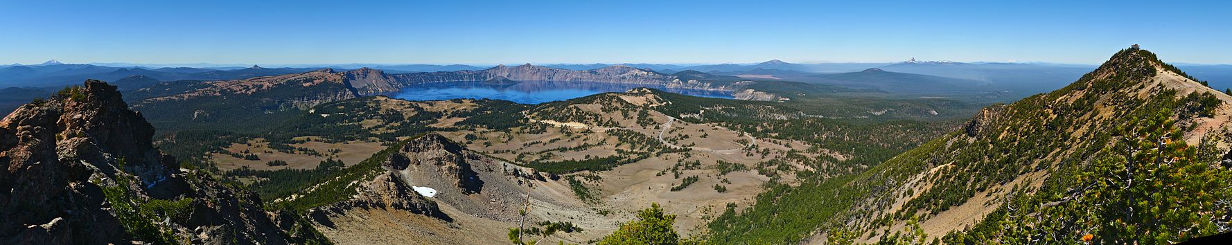 180-degree panoramic photograph of Crater Lake from the top of nearby Mount Scott, looking west. Two snow-covered peaks can be seen in the distance: to the right of the lake is Mount Thielsen, and in the far left of the photo is Mount McLoughlin.
History
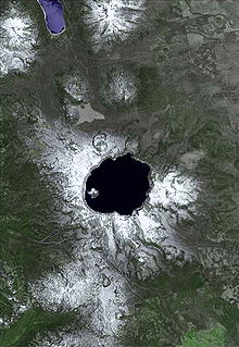
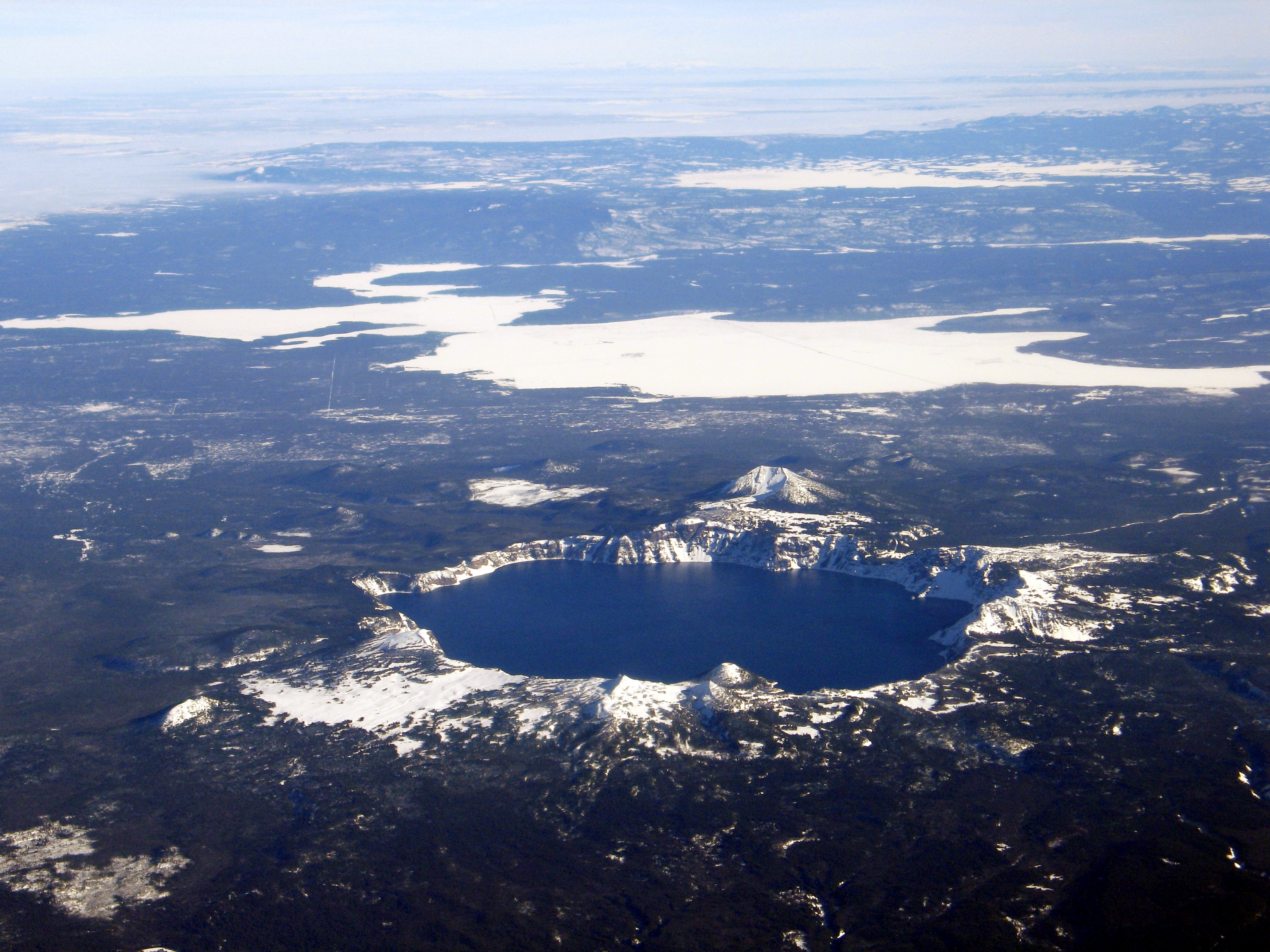
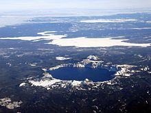 Aerial view of Crater Lake
Local Native Americans witnessed the collapse of Mount Mazama and kept the event alive in their legends. One ancient legend of the Klamath people closely parallels the geologic story which emerges from today's scientific research. The legend tells of two Chiefs, Llao of the Below World and Skell of the Above World, pitted in a battle which ended up in the destruction of Llao's home, Mt. Mazama.[12] The battle was witnessed in the eruption of Mt. Mazama and the creation of Crater Lake.
A trio of gold prospectors: John Wesley Hillman, Henry Klippel, and Isaac Skeeters were the first whites to visit the lake. On June 12, 1853, they stumbled upon the long, sloping mountain while hunting for provisions. Stunned by vibrant blue color of the lake, they named the indigo body of water "Deep Blue Lake" and the place on the southwest side of the rim where he first saw the lake later became known as Discovery Point.[3] But gold was more on the minds of settlers at the time and the discovery was soon forgotten. The suggested name later fell out of favor by locals, who preferred the name Crater Lake.
William Gladstone Steel devoted his life and fortune to the establishment and management of a National Park at Crater Lake. His preoccupation with the lake began in 1870. In his efforts to bring recognition to the park, he participated in lake surveys that provided scientific support. He named many of the lake's landmarks, including Wizard Island, Llao Rock, and Skell Head.
With the help of geologist Clarence Dutton, Steel organized a USGS expedition to study the lake in 1886. The party carried the Cleetwood, a half-ton survey boat, up the steep slopes of the mountain then lowered it to the lake. From the stern of the Cleetwood, a piece of pipe on the end of a spool of piano wire sounded the depth of the lake at 168 different points. Their deepest sounding, 1,996 feet (608 m), was very close to the modern official depth of 1,932 feet (589 m) made in 1953 by sonar.[3] At the same time, a topographer surveyed the area and created the first professional map of the Crater Lake area.
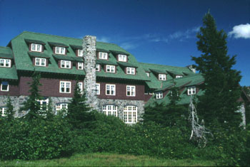
Partly based on data from the expedition and lobbying from Steel and others, Crater Lake National Park was established May 22, 1902 by President Theodore Roosevelt. And because of Steel's involvement, Crater Lake Lodge was opened in 1915 and the Rim Drive was completed in 1918.[3]
Highways were later built to the park to help facilitate tourism. The 1929 edition of O Ranger! described access and facilities available by then:
Crater Lake National Park is reached by train on the Southern Pacific Railroad lines into Medford and Klamath Falls, at which stops motor stages make the short trip to the park. A hotel on the rim of the lake offers accommodations. For the motorist, the visit to the park is a short side trip from the Pacific and Dalles-California highways. He will find, in addition to the hotel, campsites, stores, filling stations. The park is open to travel from late June or July 1 for as long as snow does not block the roads, generally until October.[13]
Although snow covers Crater Lake National Park for eight months of the year (average annual snowfall is 533 in (1,350 cm)), the lake rarely freezes over due in part to a relatively mild onshore flow from the Pacific Ocean. The last recorded year in which the lake froze over was in 1949, a very long, cold winter. A 95% surface freeze occurred in 1985. The immense depth of Crater Lake acts as a heat reservoir that absorbs and traps sunlight, maintaining the lake temperature at an average of 55 °F (12.8 °C) on the surface and 38 °F (3.3 °C) at the bottom throughout the year. The surface temperature fluctuates a bit, but the bottom temperature remains quite constant.
Activities
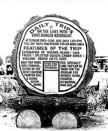 Daily Trips (1931)
There are many hiking trails inside the park, and several campgrounds. Unlicensed fishing is allowed without any limitation of size, species, or number. The lake is believed to have no indigenous fish, but several species of fish were introduced beginning in 1888 until all fish stocking ended in 1941. Kokanee Salmon (Oncorhynchus nerka) and Rainbow Trout (Oncorhynchus mykiss) now thrive and reproduce here naturally.[14] Swimming is allowed in the lake, and the boat tours, which stop at Wizard Island a cinder cone inside the lake, operate daily during the summer. All lake access for people is from Cleetwood Trail, a steep walking trail, and there are no roads for cars, trucks, or wagons that lead to the waterfront. All of the boats in the lake were delivered by helicopter.[15]
Numerous observation points along the caldera rim for the lake are readily accessible by automobile via the "Rim Drive", which is 33 miles (53 km) long and has an elevation gain of 3,800 feet (1,200 m).
The highest point in Crater Lake National Park is Mt. Scott at 8,929 feet (2,722 m). Getting there requires a fairly steep 2.5-mile (4.0 km) hike from the Rim Drive trailhead. On a clear day visibility from the summit exceeds 100 miles (160 km), and one can, in a single view, take in the entire caldera. Also visible from this point are the white-peaked Cascade Range volcanoes to the north, the Columbia River Plateau to the east, and also the Western Cascades and the more-distant Klamath Mountains to the west.
The scenery of Crater Lake is fully accessible during the summer months. Heavy snowfalls in this park during the fall, winter, and spring months force many road and trail closures, including the popular "Rim Drive", which is generally completely open from July to October, and partially open in some other months, such as May, June, and November.
See also
- List of nationally protected areas of the United States
- National Park Service Rustic about the architecture of the park structures
- National Register of Historic Places listings in Crater Lake National Park
- Volcanic Legacy Scenic Byway
Notes
- ^ Crater Lake is often referred to as the seventh deepest lake in the world, but this former listing excludes the approximately 3,000-foot (910 m) depth of subglacial Lake Vostok in Antarctica, which resides under nearly 13,000 feet (4,000 m) of ice, and the recent report of a 2,740-foot (840 m) maximum depth for Lake O'Higgins/San Martin, located on the border of Chile and Argentina
References
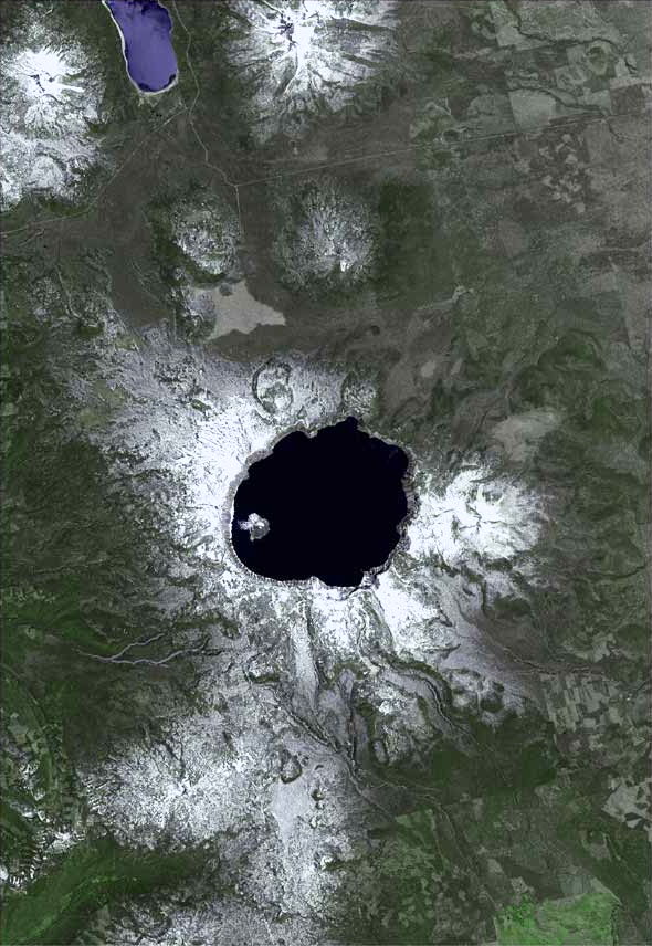
 Satellite view of Crater Lake
- ^ a b "Listing of acreage as of 12/31/2010". Public Use Statistic Office, National Park Service. http://www.nature.nps.gov/stats/Acreage/acrebypark10cy.pdf. Retrieved 2011-06-21.
- ^ "Five Year Annual Recreation Visits Report". Public Use Statistic Office, National Park Service. http://www.nature.nps.gov/stats/viewReport.cfm?selectedReport=SystemComparisonReport.cfm. Retrieved 2011-06-21.
- ^ a b c d "Crater Lake". National Park Service. http://www.nps.gov/crla/home.htm. Retrieved 2006-08-18.
- ^ Larson, Gary L.; Collier, Robert; Buktenica, Mark (January 2007). "Long-term limnological research and monitoring at Crater Lake, Oregon". Hydrobiologia (Doetinchem: Springer) 574 (1): 1–11. doi:10.1007/s10750-006-0342-6. ISSN 1573-5117. http://www.springerlink.com/content/k402u4x05321214t/fulltext.pdf. Retrieved November 12, 2009.
- ^ Manuel Nathenson; Charles R. Bacon, David W. Ramsey (2007). "Subaqueous geology and a filling model for Crater Lake, Oregon". Hydrobiologia 574: 13–27. doi:10.1007/s10750-006-0343-5.
- ^ Taylor and Hannan, pp. 39–41
- ^ "Plan Your Visit". National Park Service. 2011. http://www.nps.gov/crla/planyourvisit/index.htm. Retrieved November 11, 2011.
- ^ a b Taylor and Hannan, p. 24
- ^ Taylor and Hannan, p. 118
- ^ a b Taylor and Hannan, p. 11
- ^ Bolsinger, Charles L.; Waddell, Karen L. (1993). Area of old-growth forests in California, Oregon, and Washington. United States Forest Service, Pacific Northwest Research Station. Resource Bulletin PNW-RB-197. http://www.fs.fed.us/pnw/pubs/pnw_rb197.pdf
- ^ "Park History". National Parks Service. http://www.nps.gov/archive/crla/New%20Folder/crlacr.htm. Retrieved 2010-10-18.
- ^ Albright, Horace M.; Frank J. Taylor (1928). Oh, Ranger!. illustrated by Ruth Taylor White (Centennial ed.). Riverside, Connecticut: The Chatham Press, Inc.. http://www.cr.nps.gov/history/online_books/albright3/chap13a.htm. Retrieved 2006-08-18.
- ^ "Fish and Fishing at Crater Lake National Park". National Park Service. http://www.nps.gov/crla/brochures/fish.htm. Retrieved 2006-08-18.
- ^ Barnard, Jeff (24 July 2003). "New tour boats give Crater Lake a lift". Corvallis Gazette Times (Corvallis, OR).
Works cited
- Taylor, George H., and Hannan, Chris (1999). The Climate of Oregon: From Rain Forest to Desert. Corvallis: Oregon State University Press. ISBN 0-87071-468-6.
Further reading
- Bacon, Charles R.; James V. Gardner, Larry A. Mayer, Mark W. Buktenica, Peter Darnell, David W. Ramsey, Joel E. Robinson (June 2002). "Morphology, volcanism, and mass wasting in Crater Lake, Oregon". Geological Society of America Bulletin 114 (6): 675–692. doi:10.1130/0016-7606(2002)114<0675:MVAMWI>2.0.CO;2. ISSN 0016-7606.
- Bacon, Charles R. (2008). "Geologic map of Mount Mazama and Crater Lake Caldera, Oregon" (online version of paper map with associated booklet and database). United States Geological Survey. http://pubs.usgs.gov/sim/2832/. Retrieved November 13, 2009.
- Harmon, Rick (2002). Crater Lake National Park: A History. Corvallis: Oregon State University Press. ISBN 0-87071-537-2.
- Harris, Stephen L. (1988). Fire Mountains of the West: The Cascade and Mono Lake Volcanoes. Missoula: Mountain Press Publishing Company. ISBN 0-87842-220-X.
- Harris, Ann G.; Esther Tuttle, Sherwood D. Tuttle (1997). Geology of National Parks (Fifth ed.). Iowa: Kendall/Hunt Publishing. ISBN 0-7872-5353-7.
External links
 Media related to Crater Lake National Park at Wikimedia Commons
- "Crater Lake National Park". National Park Service. http://www.nps.gov/crla/. Retrieved 2008-11-09.
- "Crater Lake, Oregon". Earth Observatory. NASA. http://earthobservatory.nasa.gov/Newsroom/NewImages/images.php3?img_id=10902. Retrieved 2008-11-09.
- "Crater Lake National Park Trust". http://www.CraterLakeTrust.org. Retrieved 2008-11-09.
- "Crater Lake Digital Research Collection". Oregon Institute of Technology. http://craterlakelib.oit.edu. Retrieved 2009-11-12.
Crater Lake Natural places Man-made places People Designated areas Crater Lake National Park • Munson Valley Historic District • Rim Drive • Rim Village Historic District • Volcanic Legacy Scenic BywayNational parks of the United States Acadia • American Samoa • Arches • Badlands • Big Bend • Biscayne • Black Canyon of the Gunnison • Bryce Canyon • Canyonlands • Capitol Reef • Carlsbad Caverns • Channel Islands • Congaree • Crater Lake • Cuyahoga Valley • Death Valley • Denali • Dry Tortugas • Everglades • Gates of the Arctic • Glacier • Glacier Bay • Grand Canyon • Grand Teton • Great Basin • Great Sand Dunes • Great Smoky Mountains • Guadalupe Mountains • Haleakalā • Hawaiʻi Volcanoes • Hot Springs • Isle Royale • Joshua Tree • Katmai • Kenai Fjords • Kings Canyon • Kobuk Valley • Lake Clark • Lassen Volcanic • Mammoth Cave • Mesa Verde • Mount Rainier • North Cascades • Olympic • Petrified Forest • Redwood • Rocky Mountain • Saguaro • Sequoia • Shenandoah • Theodore Roosevelt • Virgin Islands • Voyageurs • Wind Cave • Wrangell-St. Elias • Yellowstone • Yosemite • Zion
Protected Areas of Oregon Federal State Arcadia Beach • Bob Straub • Bradley • Cape Kiwanda • Cape Lookout • Cape Meares • Clay Myers at Whalen Island • Del Rey Beach • Ecola • Elmer Feldenheimer • Fishing Rock • Fort Stevens • Gearhart Ocean • Haystack Hill • Hug Point • John Yeon • Manhattan Beach • Munson Creek Falls • Neahkahnie–Manzanita • Nehalem Bay • Oceanside Beach • Oswald West • Rockaway Beach • Sunset Beach • Sunset Highway Forest • Symons • Tolovana Beach • Tolovana Beach • Twin Rocks • Wilson River Highway Forest
Agate Beach • Alsea Bay • Beachside • Beaver Creek • Beverly Beach • Boiler Bay • Carl G. Washburne • Collins Creek • D River • Darlingtonia • Devils Lake • Devils Punch Bowl • Driftwood Beach • Ellmaker • Fogarty Creek • Gleneden Beach • Governor Patterson • H.B. Van Duzer • Heceta Head Lighthouse • Jessie M. Honeyman • Joaquin Miller Forest • L. Presley & Vera C. Gill • Lost Creek • Muriel O. Ponsler • Neptune • Neskowin Beach • Ona Beach • Otter Crest • Pritchard • Roads End • Rocky Creek • San Marine • Seal Rock • Smelt Sands • South Beach • Stonefield Beach • Tokatee Klootchman • W. B. Nelson • Whale Watching • Yachats • Yachats Ocean Road • Yaquina Bay
Albert H. Powers • Alfred A. Loeb • Arizona Beach • Bandon • Bolon Island Tideways • Bullards Beach • Cape Arago • Cape Blanco • Cape Sebastian • Conde B. McCullough • Coquille Myrtle Grove • Crissey Field • Elk Creek Tunnel Forest • Face Rock • Floras Lake • Geisel Monument • Golden and Silver Falls • Harris Beach • Hoffman • Humbug Mountain • Hutchinson • Maria C. Jackson • McVay Rock • Ophir • Otter Point • Paradise Point • Pistol River • Port Orford Cedar Forest • Port Orford Heads • Samuel H. Boardman • Seven Devils • Shore Acres • Sisters Rock • Sunset Bay • Sweet Myrtle • Umpqua • Umpqua Lighthouse • Umpqua Myrtle • William M. Tugman • Winchuck • Yoakam Point
Banks–Vernonia • Bonnie Lure • Government Island • L. L. "Stub" Stewart • Mary S. Young • Milo McIver • Tryon Creek • Willamette Stone
Ainsworth • Benson • Bonneville • Bridal Veil Falls • Crown Point • Dabney • Dalton Point • George W. Joseph • Guy W. Talbot • Historic Columbia River Highway • John B. Yeon • Koberg Beach • Lang Forest • Lewis and Clark • Lindsey Creek • Mayer • McLoughlin • Memaloose • Multnomah Falls • Portland Women's Forum • Rocky Butte • Rooster Rock • Seneca Fouts • Shepperd's Dell • Sheridan • Starvation Creek • Viento • Vinzenz Lausmann • Wyeth • Wygant
Alderwood • Bald Peak • Blachly Mountain Forest • Bowers Rock • Cascadia • Champoeg • Detroit Lake • Dexter • Elijah Bristow • Erratic Rock • Fall Creek • Fort Yamhill • Holman • Jasper • Lowell • Luckiamute • Maples • Maud Williamson • Molalla River • North Santiam • Sarah Helmick • Silver Falls • State Capitol • Thompson's Mills • Washburne • Willamette Mission
Ben Hur Lampman • Canyon Creek Forest • Casey • Collier Memorial • Illinois River Forks • Jackson F. Kimball • Joseph H. Stewart • Klamath Falls – Lakeview Forest • OC&E Woods Line • Prospect • Rough and Ready Forest • Stage Coach Forest • TouVelle • Tub Springs • Valley of the Rogue • Wolf Creek Inn
Cline Falls • Deschutes River • Dyer • Elliott Corbett • La Pine • Ochoco • Peter Skene Ogden • Pilot Butte • Prineville Reservoir • Redmond–Bend Juniper • Sisters • Smith Rock • The Cove Palisades • Tumalo • White River Falls
Bates • Battle Mountain Forest • Blue Mountain Forest • Booth • Catherine Creek • Chandler • Clyde Holliday • Crooked Creek • Deadman's Pass • Emigrant Springs • Farewell Bend • Fort Rock • Fort Rock Cave • Frenchglen Hotel • Goose Lake • Hat Rock • Hilgard Junction • Kam Wah Chung • Lake Owyhee • Minam • Ontario • Pete French Round Barn • Red Bridge • Succor Creek • Sumpter Valley Dredge • Ukiah–Dale Forest • Unity Forest • Unity Lake • Wallowa Lake • Wallowa Lake Highway Forest • Wallowa River
Bridge Creek • Dean Creek • Denman • E.E. Wilson • Elkhorn • Fern Ridge • Irrigon • Jewell Meadows • Klamath • Ladd Marsh • Lower Deschutes • Phillip W. Schneider • Prineville • Riverside • Sauvie Island • Snake River Islands • Summer Lake • Wenaha • White River • Willow Creek
Regions Portland metroBlue Lake • Cooper Mountain • Glendoveer • Howell • Oregon Zoo • Oxbow • Smith and Bybee • Mount Talbert
Cities PortlandForest Park • Washington Park
Categories:- IUCN Category II
- National parks in Oregon
- Civilian Conservation Corps in Oregon
- Crater Lake
- Parks in Klamath County, Oregon
- Parks in Douglas County, Oregon
- Parks in Jackson County, Oregon
- Protected areas established in 1902


Wikimedia Foundation. 2010.