- Sky Lakes Wilderness
Infobox_protected_area | name = Sky Lakes Wilderness
iucn_category = Ib
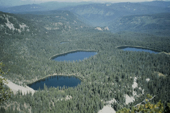
caption = Seven Lakes Basin from Devil's Peak
locator_x =
locator_y =
location =Oregon ,USA
nearest_city =Chiloquin, Oregon
lat_degrees = 42
lat_minutes = 37
lat_seconds = 07
lat_direction = N
long_degrees = 122
long_minutes = 13
long_seconds = 52
long_direction = W
area = convert|116300|acre|km2|1|sing=off
established =1984
governing_body =United States Forest Service The Sky Lakes Wilderness is awilderness area located in the Rogue River-Siskiyou andWinema National Forest s in the southernCascade Range ofOregon ,U.S. . It comprises convert|116300|acre|km2|0|sing=off. 75,695 (306 km) of which are located in the Rogue River-Siskiyou National Forest, and 40,605 (164 km) located in the Winema National Forest. [ [http://www.wilderness.net/index.cfm?fuse=NWPS&sec=acreage&WID=558 Wilderness acreage] - Wilderness.net] It was established in 1984 under theWilderness Act of 1964.Topography
Sky Lakes Wilderness straddles southern Oregon's Cascade Range from
Crater Lake National Park southward to Highway 140. It is approximately convert|6|mi|km|1|sing=off wide and convert|27|mi|km|1|sing=off long, with elevations ranging from convert|3800|ft|m|1|sing=off feet in the canyon of the Middle Fork of theRogue River , to convert|9495|ft|m|1|sing=off at the top ofMount McLoughlin , the highest peak in Southern Oregon and the highest point in the Cascade Range between the Three Sisters andMount Shasta .The Wilderness contains more than 200 pools of water, from small ponds to lakes of 30 to 40 acres. Fourmile Lake, near the southern end of the area exceeds convert|900|acre|km2|1|sing=off. [http://www.fs.fed.us/r6/rogue/wilderness_skylakes.html Rogue River National Forest - Sky Lakes Wilderness] ] Several of the lakes at Sky Lakes, including Alta and Natasha, were found to have among the most chemically pure water known of all lakes on the globe.
Geology
Geologic studies indicate that the earliest rocks in this part of the High Cascades began forming when a chain of volcanoes erupted between five and three million years ago. During the
Ice Age , the composite volcanoes ofMount Mazama andMount McLoughlin began their initial build-up. On their north and east slopes, Mt. McLoughlin and other peaks bear scars caused byglaciers . Like most other major drainages within Sky Lakes Wilderness, Seven Lakes Basin and the deep canyon of the Middle Fork of the Rogue River were carved by the massive ice fields which covered the highest elevations of the Cascades. [http://www.fs.fed.us/r6/winema/recreation/wilderness/skylakes.shtml Sky Lakes Wilderness] - Winema National Forest] Approximately 6,700 years ago, when Mt. Mazama exploded, collapsed, and formed the caldera of Crater Lake, some of the vast amount of rock and ash which was thrown into the air landed in the northern portion of Sky Lakes Wilderness, creating the pumice-covered Oregon Desert.Vegetation
Many plant species thrive in Sky Lakes Wilderness, including nearly two dozen tree species. These range from the
Pacific yew andEngelmann spruce in the lowlands to themountain hemlock andsubalpine fir at the higher elevations. Shastared fir dominates much of the Wilderness, andlodgepole pine is common, but is in its element in the Oregon Desert portion of the Wilderness.Whitebark pine is an uncommon tree in Sky Lakes, but can be found high on the slopes of Mt. McLoughlin and Devil's Peak. The forest's understory is dominated by species ofhuckleberry ,manzanita ,kinnikinnick , snowbrush, andheather . [http://www.wilderness.net/index.cfm?fuse=NWPS&sec=wildView&wname=Sky%20Lakes Sky Lakes Wilderness] - Wilderness.net]Wildlife
Elk herds spend much of the summer and early fall in the northern third of the Sky Lakes Wilderness. The entire wilderness supports roving populationspine marten s and fishers, black bears,cougars ,coyotes , as well aspika s and golden-mantled ground squirrels,goshawk s and various other species of wildlife. During October and November, migrating birds pass over in the hundreds of thousands, often stopping at the high lakes.Osprey s,eagles , and other largehawks can occasionally be seen at Sky Lakes. Uncommon animals in the area include the yellow-bellied marmot, thefisher , and thepine marten .Game fish are stocked in the Sky Lakes lakes by the State of Oregon annually. These include
brook trout ,rainbow trout ,cutthroat trout , andKokanee . Cutthroat are only stocked in Big Heavenly Twin and Isherwood lakes, and Kokanee are only stocked at Fourmile lake. [ [http://gorp.away.com/gorp/resource/us_wilderness_area/or_sky_l.htm Sky Lakes Wilderness, Oregon] - GORP]History
Beginning several thousand years ago, Native American groups - ancestors of the
Klamath and theTakelma Indians - hunted game and gathered huckleberries within the Sky Lakes Wilderness area. However, prehistoric visitors didn't spend a significant amount of time in the area due to the short season of mild weather and the limited variety of food plants and animals. Prehistoric stone tools have been found in the Wilderness.The early non-native settlers hunted, trapped beaver and marten, and grazed their stock in the high meadows. Settlers from lower-elevation communities would travel to pick huckleberries at places like Stuart Falls and Twin Ponds. After 1906 the newly established
United States Forest Service built trails and fire lookouts within the Sky Lakes area.Recreation
The
Pacific Crest Trail passes through the entire Sky Lakes Wilderness from north to south for about convert|35|mi|m|1|sing=off. The three main lake basins see quite a bit of use, particularly at the larger lakes, which are popular fishing, hiking, and camping destinations. Hunting is popular in the Wilderness, especially for elk.Points of interest
The Twin Ponds Trail follows the route of the old
Rancheria Trail , a Native American travel route. In 1863, it was widened and used as a military wagon road between Jacksonville andFort Klamath . This portion of the Rancheria Trail is listed on theNational Register of Historic Places and many segments of the old wagon route are visible the trail.At the southeast end of Island Lake is Waldo Tree. This inscribed Shasta red fir bears the carved names of early-day Oregon conservationist Judge
John Waldo and four companions. In 1888, these men hiked south along the crest of the Cascades, from Waldo Lake toMt. Shasta . They were the first recorded party to travel much of the general route of what is now the Pacific Crest Trail.References
ee also
*
Wilderness Act
*List of Oregon Wildernesses
*List of U.S. Wilderness Areas External links
* [http://www.traveloregon.com/Explore-Oregon/Southern-Oregon/Outdoor-Recreation/Other/Horseback-Riding/Pacific-Crest-National-Scenic-Trail--Sky-Lakes-Wilderness-Segment.aspx Pacific Crest Trail] - Sky Lakes Wilderness Segment
* [http://www.fs.fed.us/r6/rogue/wilderness_skylakes.html Sky Lakes Wilderness] - Rogue River National Forest
* [http://www.fs.fed.us/r6/winema/recreation/wilderness/skylakes.shtml Sky Lakes Wilderness] - Winema National Forest
* [http://www.wilderness.net/index.cfm?fuse=NWPS&sec=wildView&wname=Sky%20Lakes Sky Lakes Wilderness] - Wilderness.net
* [http://gorp.away.com/gorp/resource/us_wilderness_area/or_sky_l.htm Sky Lakes Wilderness, Oregon] - GORP
* [http://media.barometer.orst.edu/media/storage/paper854/news/2003/01/31/Diversions/Sky-Lakes.Wilderness.A.Hidden.Treasure-2295176.shtml Sky Lakes Wilderness: a hidden treasure] by Melissa Lindbloom, the Daily Barometer
Wikimedia Foundation. 2010.