- Oregon Route 140
-
For the unsigned Highway 140, see Hillsboro-Silverton Highway.
Oregon Route 140
Route information Maintained by ODOT Length: 237.01 mi (381.43 km) Major junctions West end:  OR 62 in White City
 US 97 and OR 66 in Klamath Falls
 OR 39 near Altamont
 OR 70 in Dairy
 US 395 in Lakeview
US 395 near LakeviewEast end:  SR 140 near Adel
Highway system Oregon highways
Routes • Highways←  OR 138
OR 141  →
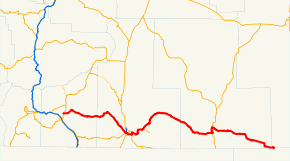
→Oregon Route 140 is an Oregon state highway that serves the southern portion of the state. It runs from the community of White City, Oregon (just north of Medford), through Klamath Falls and on to Lakeview. It then continues east, eventually descending into the state of Nevada.
Route description
Oregon Route 140 begins in the city of White City, at a junction with Oregon Route 62 (which runs between Medford and Crater Lake National Park). Oregon Route 140 is the primary connection between Medford and Klamath Falls. The stretch of OR 140 between the two cities is known as the Lake of the Woods Highway No. 270 (see Oregon highways and routes), as it passes by the scenic Lake of the Woods and Mount McLoughlin in the Sky Lakes Wilderness. It then runs along the southwestern shore of Upper Klamath Lake, where it is part of the Volcanic Legacy Scenic Byway. Eventually, OR 140 enters the Klamath Falls area; it joins together with Oregon Route 66 (which runs between Klamath Falls and Ashland) on the Green Springs Highway No. 21, and the two highways soon intersect with U.S. Route 97 at a freeway interchange.
OR 140 continues east of here, on an alignment known either as the South Klamath Falls Highway No. 424 or the Southside Bypass. Southeast of town, OR 140 intersects with Oregon Route 39, heads north on a shared alignment for about two miles (3 km), on the Klamath Falls-Malin Highway No. 50, and then continues east towards Lakeview on the Klamath Falls-Lakeview Highway No. 20.
In Lakeview, the highway intersects with U.S. Route 395 over the Fremont Highway No. 19 and then continues east on the Warner Highway No. 431 eventually dropping down into Nevada. Oregon Route 140 ends at the Nevada state line, where it becomes State Route 140.
Major intersections
- Note: OR 140 uses many different highways (see Oregon highways and routes); the milepoint column shows mileage along these highways, not adjusted for equations, with the highway number in front.
County Location Milepoint[1] Destinations Notes Jackson 270 0.00 OR 62 – Eagle Point, Crater Lake, MedfordKlamath 270 43.58 Westside Road – Rocky Point, Fort Klamath, Crater Lake National Park Former Klamath Lake Highway Klamath Falls 270 68.76
21 58.86 OR 66 west – Keno, AshlandWest end of OR 66 overlap 21 59.05
424 0.00 US 97 – Klamath Falls, Bend, WeedEast end of OR 66 overlap 424 1.57 Tingley Lane (Midland Highway) 424 2.80 Washburn Way Interchange; signed as exit 3 424 5.97
50 1.78 OR 39 south – Merrill, AlturasWest end of OR 39 overlap 50 0.00
20 5.54 OR 39 north – Klamath Falls, BendEast end of OR 39 overlap Dairy 20 19.02 OR 70 east – Bonanza, LorellaLake Lakeview 20 96.37
19 143.03 US 395 south – Alturas, RenoWest end of US 395 overlap 19 138.34
431 0.00 US 395 north – Burns, BendEast end of US 395 overlap Adel 431 28.18 Plush-Adel Road, Twenty Mile Road – Plush, Hart Mountain Refuge, Fort Bidwell, Coleman Valley Former Warner Highway (north to Plush) Harney 431 65.28 Nevada state line References
- ^ Oregon Department of Transportation, Public Road Inventory (primarily the Digital Video Log), accessed March 2008
Categories:- State routes in Oregon
- Transportation in Jackson County, Oregon
- Transportation in Klamath County, Oregon
- Transportation in Lake County, Oregon
- Transportation in Harney County, Oregon


Wikimedia Foundation. 2010.