- U.S. Route 395 in Oregon
-
This article is about the section of U.S. Route 395 in Oregon. For the entire length of the highway, see U.S. Route 395.
U.S. Route 395
Route information Maintained by Oregon DOT Major junctions South end:  US 395 at California state line
 OR 140 in Lakeview
 US 20 in Riley and Burns
 US 26 in Canyon City
 I-84 in Pendleton
North end: 
 US 395 / I-82 at Washington state line
Highway system United States Numbered Highways
List • Bannered • Divided • ReplacedOregon highways
Routes • Highways←  OR 380
OR 402  →
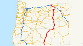
→In the U.S. state of Oregon, U.S. Route 395 traverses the desert and rural areas on the eastern side of the state. The largest cities that US 395 passes through are Pendleton, the county seat of Umatilla County, and Hermiston, also in Umatilla County.
Major intersections
- Note: mileposts do not reflect actual mileage due to realignments.
County Location Mile[1] Destinations Notes Lake New Pine Creek 157.73 California state line Lakeview 143.03 OR 140 west – Bly, Klamath FallsSouth end of OR 140 overlap 138.34 OR 140 east – Adel, Plush, WinnemuccaNorth end of OR 140 overlap Valley Falls 120.57
90.02 OR 31 – Paisley, Silver Lake, Bend
Harney Riley 0.11
104.77 US 20 west – Bend, Redmond, PortlandSouth end of US 20 overlap Burns 131.50  OR 78 – Crane, Winnemucca
134.29
67.61 US 20 east – Vale, OntarioNorth end of US 20 overlap Grant Canyon City 0.00
162.29 US 26 east – Prairie City, Vale, Baker CitySouth end of US 26 overlap Mount Vernon 154.03
120.51 US 26 west – Dayville, Prineville, PortlandNorth end of US 26 overlap Long Creek 90.26 OR 402 – Hamilton, Monument, KimberlyUmatilla 49.57  OR 244 east – Ukiah, La Grande
Nye 23.65  OR 74 west – Heppner, Condon
Pendleton 1.57
209.17 I-84 east / OR 37 north, Pendleton City Center
Interchange; south end of I-84 overlap; south end of freeway 207.47  US 30 east – Eastern Oregon Regional Airport, West Pendleton, Pendleton City Center
South end of US 30 overlap 202.87 Barnhart Road – Stage Gulch 199.53 Yoakum Road – Stage Gulch 198.54 Lorenzen Road, McClintock Road 193.53 Echo Road – Echo, Lexington Former Lexington-Echo Highway Stanfield 188.98
12.68 I-84 west / US 30 west (Lexington-Echo Highway) – Boardman, EchoInterchange; north end of I-84 / US 30 overlap; north end of freeway Hermiston 4.83  OR 207 – Heppner, Walla Walla
Umatilla 0.04
184.87 US 730 east – Walla Walla, McNary Dam
South end of US 730 overlap 184.40
0.79 I-82 east to I-84 / US 730 west – Pendleton, Portland, Umatilla, IrrigonInterchange; north end of US 730 overlap; south end of I-82 overlap 0.00 Umatilla Bridge over the Columbia River (state line) References
- ^ Oregon Department of Transportation, Public Road Inventory (primarily the Digital Video Log), accessed April 2008
U.S. Route 395Previous state:
CaliforniaOregon Next state:
WashingtonCategories:- U.S. Route 95
- U.S. Highways in Oregon
- Transportation in Lake County, Oregon
- Transportation in Umatilla County, Oregon
- Transportation in Grant County, Oregon
- Transportation in Harney County, Oregon
- Lakeview, Oregon


Wikimedia Foundation. 2010.