- Dayville, Oregon
-
Dayville, Oregon — City — Ridge north of Dayville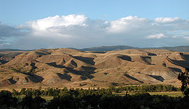 Location in Oregon
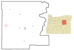
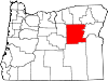
Coordinates: 44°28′0″N 119°32′0″W / 44.466667°N 119.533333°WCoordinates: 44°28′0″N 119°32′0″W / 44.466667°N 119.533333°W Country United States State Oregon County Grant Incorporated 1913 Government – Mayor Jody Winkelman Area – Total 0.5 sq mi (1.3 km2) – Land 0.5 sq mi (1.3 km2) – Water 0 sq mi (0 km2) Elevation 2,348 ft (715.67 m) Population (2000) – Total 138 – Density 269.5/sq mi (104.5/km2) Time zone Pacific (UTC-8) – Summer (DST) Pacific (UTC-7) ZIP Code 97825 Area code(s) 541 FIPS code 41-18300[1] GNIS feature ID 1140680[2] Dayville is a city in Grant County, Oregon, United States. It was incorporated in 1913.[3] The population was 138 at the 2000 census.
Contents
Geography
According to the United States Census Bureau, the city has a total area of 0.5 square miles (1.3 km2), all land.
The city is 125 miles (201 km) east of Bend, Oregon, in the John Day valley, at the confluence of the main stem of the John Day River with the South Fork John Day River. Main Street in Dayville is U.S. Route 26, lined with large cottonwood trees.
Picture Gorge, named for Native American pictographs painted on the canyon walls, is 6 miles (10 km) miles northwest of Dayville at the intersection of Route 26 and Oregon Route 19. The Sheep Rock Unit of the John Day Fossil Beds National Monument, including the Thomas Condon Paleontology Center and the James Cant Ranch Historic District and museum, are 2 miles (3 km) miles north of Picture Gorge along Route 19.[4]
Economy
Dayville’s main industries are agriculture, timber, and tourism.[5] The town is home to Dayville School District, a K–12 system with a total of about 50 students in 2007.[6]
The Dayville Presbyterian Church[7] has, since the 1970's offered hospitality to bicyclists journeying along the TransAmerica bicycle trail.[8][9][10][11][12]
Demographics
As of the census[1] of 2000, there were 138 people, 59 households, and 36 families residing in the city. The population density was 269.5 people per square mile (104.5/km²). There were 77 housing units at an average density of 150.4 per square mile (58.3/km²). The racial makeup of the city was 96.38% White, 2.17% Native American, 0.72% Asian, and 0.72% from two or more races.
There were 59 households out of which 27.1% had children under the age of 18 living with them, 49.2% were married couples living together, 11.9% had a female householder with no husband present, and 37.3% were non-families. 32.2% of all households were made up of individuals and 10.2% had someone living alone who was 65 years of age or older. The average household size was 2.34 and the average family size was 3.05.
In the city the population was spread out with 24.6% under the age of 18, 5.8% from 18 to 24, 24.6% from 25 to 44, 23.9% from 45 to 64, and 21.0% who were 65 years of age or older. The median age was 42 years. For every 100 females there were 89.0 males. For every 100 females age 18 and over, there were 96.2 males.
The median income for a household in the city was $30,893, and the median income for a family was $33,438. Males had a median income of $27,083 versus $25,417 for females. The per capita income for the city was $18,319. There were 12.2% of families and 16.1% of the population living below the poverty line, including 26.5% of under eighteens and none of those over 64.
Climate
The town has a high-desert climate that averages 33 °F (1 °C) in January and 69 °F (21 °C) in July. Annual precipitation averages about 12 inches (30 cm), and about 12 inches (30 cm) of snow a year falls in Dayville.[13]
Climate data for Dayville, Oregon Month Jan Feb Mar Apr May Jun Jul Aug Sep Oct Nov Dec Year Average high °F (°C) 43
(6)50
(10)56
(13)64
(17)72
(22)80
(26)90
(31)88
(30)80
(26)67
(19)53
(11)45
(7)66
(18)Average low °F (°C) 24
(−4)28
(−2)29
(−1)33
(0)40
(4)46
(7)49
(9)48
(8)41
(4)34
(0)30
(−1)26
(−3)35
(1)Precipitation inches (cm) 1.3
(3)0.8
(2)1
(2)0.9
(2)1.6
(4)1.2
(2)0.4
(1)0.5
(1)0.5
(1)0.9
(2)1.1
(2)1.3
(3)11.6
(29)Source: Weatherbase[13] References
- ^ a b "American FactFinder". United States Census Bureau. http://factfinder.census.gov. Retrieved 2008-01-31.
- ^ "US Board on Geographic Names". United States Geological Survey. 2007-10-25. http://geonames.usgs.gov. Retrieved 2008-01-31.
- ^ "Oregon Blue Book: Incorporated Cities: Dayville". Oregon State Archives. http://bluebook.state.or.us/local/cities/ad/dayville.htm. Retrieved 2007-08-21.
- ^ "John Day Fossil Beds: Directions". National Park Service, U.S. Department of the Interior. http://www.nps.gov/joda/planyourvisit/directions.htm. Retrieved 2007-09-10.
- ^ "Welcome to Dayville". Grant County Chamber of Commerce. 2007. http://www.grantcounty.cc/communities/dayville.html. Retrieved 2007-08-29.
- ^ "Dayville School: Home of the Tigers". Dayville School. 2007. http://www.grantesd.k12.or.us/Dayville/index.htm. Retrieved 2007-08-29.
- ^ "Eastern Oregon Presbytery Congregations". http://www.pbyofeasternoregon.org/Congregations/index.html. Retrieved Nov 9, 2011.
- ^ "TransAmerica Trail - Adventure Cycling Association". http://www.adventurecycling.org/routes/transamerica.cfm?pg=detail&s=2. Retrieved Nov 09, 2011.
- ^ "Mike and Marilyn's 2001 TransAmerica Bike Trip August 5 - Oregon". http://www.biketrip2001.com/Oregon/8-5.htm. Retrieved Nov 9, 2011.
- ^ "America by Transam Route 2010: Off to Dayville:". June 1, 2010. http://www.crazyguyonabike.com/doc/page/?o=1r4vFZo&page_id=149522&v=1p.
- ^ "Andy's TransAmerica Trail Cycle 2008: God Rocks". June 3, 2008. http://www.transamericatrailcycle.com/2008/06/god-rocks.html. Retrieved Nov 9, 2011.
- ^ "Discovery Ride Cycle Across America 2002, Day 57 - Sunday, August 4, 2002, Austin Junction to Dayville, OR (Dayville Prebyterian Church hostel)". Aug 8, 2002. http://www.discoveryride.com/log/57.html.
- ^ a b "Weatherbase: Historical Weather for Dayville, Oregon, United States of America". Weatherbase. 2007. http://www.weatherbase.com/weather/weather.php3?s=861253&refer=. Retrieved 2007-08-29.
External links
- Dayville page at Grant County Chamber of Commerce
- Listing for Dayville in the Oregon Blue Book
- Dayville School
Municipalities and communities of Grant County, Oregon Cities Canyon City | Dayville | Granite | Greenhorn | John Day | Long Creek | Monument | Mount Vernon | Prairie City | Seneca
Unincorporated
communitiesGhost towns Dixie | Galena | Susanville
Categories:- Cities in Oregon
- Populated places in Grant County, Oregon


Wikimedia Foundation. 2010.