- Oregon Route 19
-
For the unsigned Highway 19, see Fremont Highway.
Oregon Route 19
Route information Maintained by ODOT Length: 120.77 mi (194.36 km) Existed: 1932 – present Major junctions South end:  US 26 near Dayville
 OR 402 in Kimberly
 OR 207 near Spray
OR 207 in Service Creek
 OR 218 in Fossil
 OR 206 in Condon
North end:  I-84 in Arlington
Highway system Oregon highways
Routes • Highways←  OR 18
OR 18US 20  →
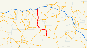
→Oregon Route 19 is an Oregon state highway in the north-central part of the state. It runs from Interstate 84 at Arlington in the Columbia River Gorge to a junction with U.S. Route 26 in Grant County, near the Sheep Rock Unit of the John Day Fossil Beds National Monument. Oregon Route 19 is the northern portion of the John Day Highway No. 5 (see Oregon highways and routes) and follows the John Day River from Service Creek to its southern terminus. The route has two brief overlaps Oregon Route 206 and Oregon Route 207, both on the portions of those routes included in the Wasco-Heppner Highway No. 300.
Major intersections
- Note: mileposts do not reflect actual mileage due to realignments.
County Location Mile[1] Destinations Notes Grant 124.17 US 26 – Mitchell, Prineville, Dayville, John DayKimberly 105.23 OR 402 – Monument, Long CreekWheeler 95.56 OR 207 north – Hardman, HeppnerSouth end of OR 207 overlap Service Creek 78.56 OR 207 south – Mitchell, PrinevilleNorth end of OR 207 overlap Fossil 58.15 OR 218 west – Antelope, Shaniko, John Day Fossil Beds National Monument (Clarno Unit)Gilliam Condon 38.27 OR 206 east – Lonerock, HeppnerSouth end of OR 206 overlap 38.07 OR 206 west – WascoNorth end of OR 206 overlap Arlington 0.00  I-84 / US 30 – The Dalles, Pendleton
Interchange References
- ^ Oregon Department of Transportation, Public Road Inventory (primarily the Digital Video Log), accessed April 2008
Categories:- State routes in Oregon
- Transportation in Grant County, Oregon
- Transportation in Gilliam County, Oregon
- Transportation in Wheeler County, Oregon
- Western United States road stubs


Wikimedia Foundation. 2010.