- The Dalles, Oregon
-
The Dalles, Oregon The Dalles and the Columbia River as seen from Kelly Viewpoint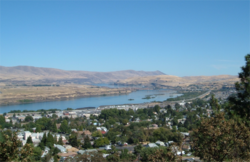

SealLocation in Oregon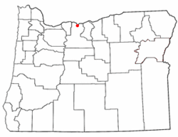
Coordinates: 45°36′4″N 121°10′58″W / 45.60111°N 121.18278°WCoordinates: 45°36′4″N 121°10′58″W / 45.60111°N 121.18278°W County Wasco County Incorporated 1857 Government – Mayor Jim Wilcox[1] Area – Total 8.95 sq mi (14.4 km2) – Land 8.45 sq mi (13.6 km2) – Water 0.5 sq mi (0.8 km2) Elevation 109 ft (33 m) Population (2009) – Total 12,314 – Density 1,438.6/sq mi (892.3/km2) Time zone Pacific (UTC−8) – Summer (DST) Pacific (UTC−7) ZIP code 97058 Area code(s) 458 and 541 Website www.ci.the-dalles.or.us - This page is about the city in Oregon. For the nearby geological formation called The Dalles, see Celilo Falls. For other uses see Dalles.
The Dalles (
 /ˈdælz/) is the largest city and county seat of Wasco County, Oregon, United States. The name of the city comes from the French word dalle (meaning either "sluice" or "flagstone" and referring to the columnar basalt rocks carved by the river,[2][3] what the French-Canadian employees of the North West Company called the now-inundated rapids of the Columbia River between the present-day city and Celilo Falls. The population was 12,156 at the 2000 census and was estimated at 12,314 in 2009.[4] Also in the same area was the Petite Dalles or Little Dalles, or Short Narrows, which is now also inundated.
Contents
History
The site of what is now the city of The Dalles was a major Native American trading center for at least 10,000 years. The general area is one of the continent's most significant archaeological regions.[5]
Lewis and Clark camped near Mill Creek on October 25–27, 1805, and recorded the Native American name for the creek as Quenett. The first use of the name Dalles, according to Oregon Geographic Names, appears in fur trader Gabriel Franchère's Narrative, on April 12, 1814, referring to the long series of major rapids in the river.[3] By 1814 several overland groups of the land components of the Astor Expedition of 1810-1812 would have passed by and explored the vicinity of the rapids. In 1811 British fur trader of the Montreal-based North West Company (NWC) began traveling through The Dalles area. In July 1811 David Thompson of the NWC voyaged down the Columbia River, reaching the partially constructed Fort Astoria of the American rival Pacific Fur Company. When Thompson's party returned upriver a small Astorian party accompanied him as far as the rapids at The Dalles. The Astorian party went on to found Fort Okanogan.[6] The War of 1812 led to the 1813 sale of Fort Astoria and the entire Pacific Fur Company to the North West Company.[7]
In 1821 the North West Company was absorbed by the giant London-based Hudson's Bay Company (HBC). Fort Vancouver, built in 1824, replaced Fort Astoria as the regional fur trade headquarters. The HBC's trading network made extensive use of the Columbia River. The rapids of the Columbia River at The Dalles was the largest and longest of the four "great portages", where fur trading boats had to unload and transship their cargoes. Sometimes, during high water, boats traveling downriver would "shoot the rapids" instead of portaging, although the practice was dangerous and many people died as a result over the years.[8]
In 1838 a branch of Jason Lee's Methodist mission was established at The Dalles. It was called "Wascopam", after the native Wasco people.[9] In the early 1840s American settlers began to arrive in significant numbers, traveling overland via the Oregon Trail. The trail ended at The Dalles. It was not possible to take wagons farther west due to steep cliffs that fell straight into the Columbia River. Until the construction of the Barlow Road in 1846, the only way to reach Fort Vancouver and the Willamette Valley was by rafting down the river from The Dalles.[9]
In 1848, at the start of the Cayuse War, the mission buildings at The Dalles were occupied by volunteer militia. In 1850 the U.S. Army founded a small post at the site of the old mission. In 1853 it was named Fort Drum and shortly after, Fort Dalles. The post became the nucleus of the town of The Dalles, which began to develop along the waterfront.[9] In 1855, at the end of the Cayuse War, the Native Americans living near The Dalles were forceably relocated by the U.S. Army to the Warm Springs Indian Reservation.[9]
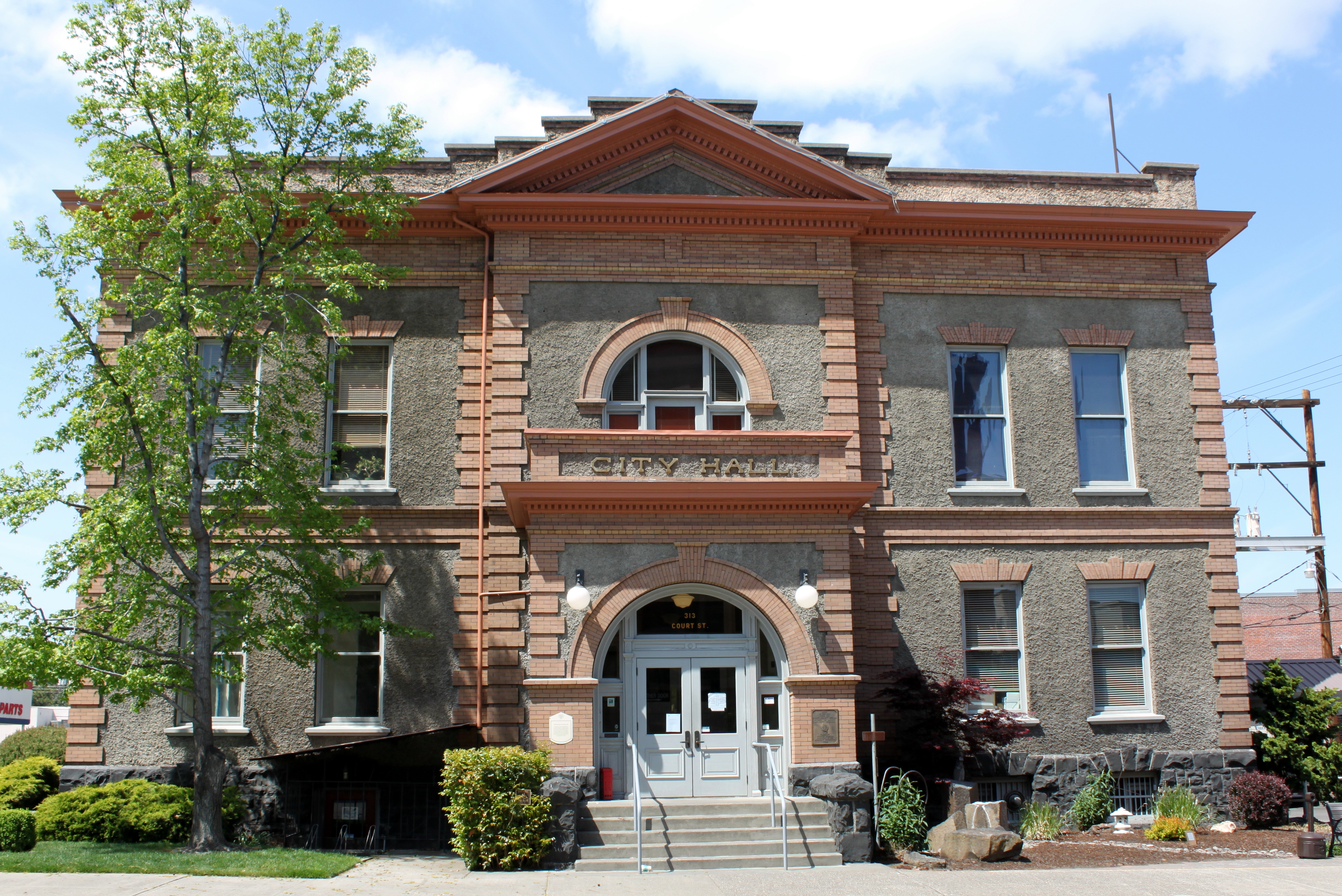
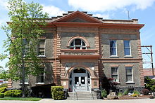 The Dalles City Hall
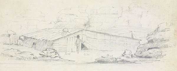
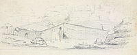 Early illustration of The Dalles, attributed to Joseph Drayton
A post office was established within the boundaries of the current city in 1851, and The Dalles was incorporated as a city in 1857. It has been the major commercial center between Portland and Pendleton since. The city was original named just "Dalles". In 1853 it was changed to" Wascopum", then, in 1860, to "The Dalles".[5]
In 1864, the U.S. Congress appropriated money to build a U.S. mint in The Dalles that was to use gold from Canyon City for coinage. The supply of gold from Canyon City began to dwindle, however, and other problems, such as cost over-runs, workers leaving to work the gold fields, and flooding from the Columbia River, also contributed to the project running two years behind schedule and led eventually to the its demise. In 1870, the State of Oregon received the property from the U.S. Government and the building was put to other uses.[10] The mint is now home to Erin Glenn Winery.[11]
Construction of The Dalles Dam in 1957 submerged the Long Narrows and Celilo Falls.
In 1963, Ken Kesey's novel One Flew Over the Cuckoo's Nest was published featuring the narrator, Chief, who is from The Dalles.[12]
In 1970, the Bonneville Power Administration opened the Celilo Converter Station nearby, the northern terminus of the Pacific DC Intertie which sends 3,100 megawatts of electricity to Los Angeles.
In 1982 a curly-coated kitten was born on a farm in The Dalles owned by Linda and Dick Koehl. The Koehls used this kitten and her offspring to develop a new breed of cat called the LaPerm, which went on to become a popular, established, championship pedigree cat breed around the world.[13]
In 1986, Penalty Phase, a film starring Peter Strauss and Melissa Gilbert, was filmed in and around The Dalles.[14]
In 2006, the Internet company Google began building a major data center, known locally as Project 02, along the Columbia River in The Dalles, using the area's reliable hydroelectric power and the underutilized fiber optic capacity of the area. The new complex includes two buildings, each approximately the size of a football field, and two cooling plants, each four stories high. The project has created hundreds of jobs in the area, mainly in construction, with an additional 200 permanent positions expected later in 2006.[15][16]
Terrorism
In 1984, The Dalles was the scene of a bioterrorist incident launched by the Rajneeshee cult in an attempt to gain control of the local government of Wasco County. Salmonella placed in ten restaurants resulted in 751 cases of Salmonellosis. It was the first known bioterrorism attack of the 20th century in the United States.[17]
Geography
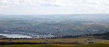 The Dalles and the Columbia River showing surrounding landscape
Highways I-84, U.S. 30, and U.S. 197 meet in the city.
According to the United States Census Bureau, the city has a total area of 14.4 km2. 13.6 km2 of it is land and 0.8 km2 of it (5.23%) is water.[18]
Climate
The Dalles is usually classified as a cool semiarid (Koppen BSk) climate region. However it has some characteristics of the midlatitude oceanic climate that dominates west of the Cascade Mountains, combined with seasonal precipitation patterns very similar to those found in Mediterranean climates. The city's location in the eastern Columbia Gorge results in there being numerous microclimates within a few miles of town.
The summer season runs from mid-June through early September and is quite warm by Pacific Northwest standards; however, summer weather often oscillates between intense heat waves and much cooler and windier periods. Except for the occasional sporadic thunderstorm, there is almost no summer rainfall.
From late September through early November, the area experiences an abrupt autumn during which normal temperatures drop very rapidly and cloudy, wet weather quickly picks up. Prior to the sudden onset of the rainy season in mid- to late fall, there are often days with a very wide disparity between daytime and nighttime temperatures, sometimes exceeding 20 C / 36 F. There is far less wind in the fall than in spring and early summer.
Winter is the rainy season in The Dalles. Despite the rain shadow effect created by the Cascades, there is still enough precipitation most years to support relatively high soil moisture levels throughout the winter. The area receives measured snowfall virtually every year, but the snow totals fluctuate dramatically from one year to the next. Average winter temperatures are only about 2-3 C (3-5 F) degrees colder than in cities such as Portland and Seattle, and temperatures below -20 C (-4 F) are very rare, but not unheard of. As in the summer, winter temperatures can vary tremendously from one day to the next: during arctic air events the daytime high temperatures will generally be well below 0C / 32F, while a strong subtropical push can raise temperatures into the 50s and low 60s F, even in January. It is quite common for relatively cold air to become trapped at low elevations due to an inversion above; depending on the temperature of the surface airmass, depth of the inversion layer, and temperatures above the inversion layer, this can result in snow, sleet, freezing rain or a very cold liquid rain.
Springtime conditions generally run from late February through early June, during which time the overall trend gradually becomes warmer and drier. This is the windiest season of all, with a powerful west wind on most afternoons. During stormy periods in spring it is usually cloudy and cool, while most sunny and calm days become intensely warm. Spring temperatures often vary more from one week to the next than they do from one month to the next.
The growing season exceeds 200 days in a majority of years, generally running from early April through most of October.
Climate data for The Dalles, Oregon Month Jan Feb Mar Apr May Jun Jul Aug Sep Oct Nov Dec Year Record high °F (°C) 68
(20)69
(21)80
(27)95
(35)107
(42)108
(42)111
(44)110
(43)105
(41)90
(32)72
(22)66
(19)111
(44)Average high °F (°C) 41
(5)48
(9)57
(14)65
(18)74
(23)80
(27)88
(31)88
(31)81
(27)67
(19)50
(10)42
(6)65
(18)Average low °F (°C) 30
(−1)32
(0)37
(3)43
(6)50
(10)56
(13)61
(16)61
(16)52
(11)42
(6)35
(2)30
(−1)44
(6)Record low °F (°C) −19
(−28)−25
(−32)11
(−12)23
(−5)28
(−2)37
(3)40
(4)42
(6)29
(−2)15
(−9)−1
(−18)−9
(−23)−25
(−32)Precipitation inches (cm) 2.6
(6.7)1.9
(4.7)1.2
(2.9)0.7
(1.9)0.6
(1.4)0.4
(1.1)0.2
(0.4)0.3
(0.8)0.5
(1.3)1.0
(2.5)2.2
(5.6)2.6
(6.8)14.3
(36.3)Source: weather.com[19] - Annual Average High Temperatures: 88 °F (summer) 41 °F (winter)
- Annual Average Low Temperatures 61 °F (summer) 30 °F (winter)
- Highest Recorded Temperature: 111 °F (1998)
- Lowest Recorded Temperature: -25 °F (1950)
- Warmest Month: July
- Coolest Month: January
- Highest Precipitation: December
- Annual Precipitation: 14.28 inches
Demographics
Historical populations Census Pop. %± 1860 802 — 1870 942 17.5% 1880 2,232 136.9% 1890 3,239 45.1% 1900 3,542 9.4% 1910 4,880 37.8% 1920 5,807 19.0% 1930 5,833 0.4% 1940 6,266 7.4% 1950 7,676 22.5% 1960 10,493 36.7% 1970 10,423 −0.7% 1980 10,820 3.8% 1990 11,060 2.2% 2000 12,156 9.9% Est. 2009 12,314 1.3% source:[20][21] As of the census[22] of 2000, there were 12,156 people, 4,896 households, and 3,226 families residing in the city. The population density was 892.3/km2. There were 5,227 housing units at an average density of 383.7/km2. The racial makeup of the city was 87.83% White, 0.39% African American, 1.20% Native American, 0.96% Asian, 0.77% Pacific Islander, 6.23% from other races, and 2.62% from two or more races. Hispanic or Latino of any race were 10.50% of the population.
There were 4,896 households out of which 30.0% had children under the age of 18 living with them, 51.1% were married couples living together, 10.6% had a female householder with no husband present, and 34.1% were non-families. 29.2% of all households were made up of individuals, and 13.5% had someone living alone who was 65 years of age or older. The average household size was 2.40, and the average family size was 2.94.
In the city, the population was spread out, with 24.8% under the age of 18, 7.9% from 18 to 24, 25.7% from 25 to 44, 23.5% from 45 to 64, and 18.1% who were 65 years of age or older. The median age was 39 years. For every 100 females, there were 94.7 males. For every 100 females age 18 and over, there were 91.5 males.
The median income for a household in the city was $35,430, and the median income for a family was $43,041. Males had a median income of $36,387 versus $22,583 for females. The per capita income for the city was $17,511. About 9.0% of families and 12.4% of the population were below the poverty line, including 16.6% of those under age 18 and 8.6% of those age 65 or over.
Arts and culture
Annual cultural events
The Northwest Cherry Festival is held in The Dalles in April.[23]
Museums and other points of interest
- The Discovery Center, the official[24] interpretive center for the Columbia River Gorge National Scenic Area
- Fort Dalles Museum, Oregon's oldest history museum located in the Surgeon's Quarters built in 1856 at Fort Dalles[25]
- Pulpit Rock, used by Methodist missionaries to preach to the Native Americans[26]
Parks and recreation
Sorosis Park is a 45-acre (180,000 m2) park in The Dalles. City Park is a 1.13-acre (4,600 m2) park close to downtown The Dalles. Firehouse Park is a 0.8-acre (3,200 m2) park located on the Columbia View Heights across from East Knoll. Thompson Park is a 12-acre (49,000 m2) park (6 developed, 6 non developed) located on 2nd Street on the west end of the historical district. Howe Park is a 1-acre (4,000 m2) neighborhood park located adjacent to The Dalles Middle School on the east end. Riverfront Park is a water front 10-acre (40,000 m2) developed park located just north of I84. Kramer Field Complex is a 16.5-acre (67,000 m2) sports complex which houses Little League, Babe Ruth, softball and soccer fields, owned by Wasco County and managed by Parks and Rec. Ted Walker Memorial Pool is a 50 meter outdoor swimming pool located within Thompson Park.
Media
Radio
- KACI (1300 AM)
- KODL (1440 AM)
- KMSW (92.7 FM)
- KACI-FM (97.7 FM)
- KCGB-FM (105.5 FM)
Television
Notable people
- Alan Embree, Major League Baseball player
- Lefty Bertrand, Major League Baseball player
- Jennifer Lyon, Survivor: Palau contestant
- John Callahan, cartoonist, grew up in The Dalles.
- H. L. Davis, Oregon's only Pulitzer Prize winner in Literature with "Honey in the Horn" (1936)[27]
- Ken Dayley, Major League Baseball player
- Todd Nelson, retired touring professional tennis player
- Philip Whalen, a poet associated with the Beat Generation, grew up in The Dalles.
- Ken Miller (Football Coach) Head Coach of the Saskatchewan Roughriders
Sister cities
The Dalles has one sister city:
 Miyoshi City, Japan (formerly Ikeda)[28]
References
- ^ "City of The Dalles". http://www.ci.the-dalles.or.us/newsite/?q=/city_council.
- ^ Gibson, James R. (1997). The Lifeline of the Oregon Country: The Fraser-Columbia Brigade System, 1811-47. University of British Columbia (UBC) Press. pp. 125. ISBN 0774806435. http://books.google.com/books?id=4imt4oeWrr0C&pg=PA125.
- ^ a b McArthur, Lewis A.; McArthur, Lewis L. (1992) [First published 1928]. Oregon Geographic Names (6th ed.). Portland, Oregon: Oregon Historical Society Press. p. 826. ISBN 9780875952369. OCLC 25874046.
- ^ PSU:Population Research Center
- ^ a b "Historic The Dalles". Wasco County Historical Society. http://www.historicthedalles.org/the_dalles-history.htm. Retrieved 28 August 2011.
- ^ Gibson, James R. (1998). The Lifeline of the Oregon Country: The Fraser-Columbia Brigade System, 1811-47. UBC Press. pp. 5–6. ISBN 978-0-7748-0643-5. http://books.google.com/books?id=4imt4oeWrr0C&pg=PA6. Retrieved 28 August 2011.
- ^ "Fort Astoria, 1813". Oregon Historical Society. http://www.ohs.org/education/oregonhistory/historical_records/dspDocument.cfm?doc_ID=1BB54FF5-E32A-ADF7-9FC4C75B10C2B48D. Retrieved 28 August 2011.
- ^ Gibson, James R. (1998). The Lifeline of the Oregon Country: The Fraser-Columbia Brigade System, 1811-47. UBC Press. p. 114. ISBN 978-0-7748-0643-5. http://books.google.com/books?id=4imt4oeWrr0C&pg=PA6. Retrieved 28 August 2011.
- ^ a b c d "Fort Dalles History". Fort Dalles Museum and the Anderson Homestead. http://www.fortdallesmuseum.org/fort-dalles_history.htm. Retrieved 28 August 2011.
- ^ Wasco History
- ^ Erin Glenn Wines at The Mint | Columbia Gorge Winery | The Dalles, Oregon
- ^ http://www.cliffsnotes.com/WileyCDA/LitNote/One-Flew-Over-the-Cuckoo-s-Nest-Summary-and-Analysis-They-re-Out-There.id-136,pageNum-13.html
- ^ "History of the Breed". The LaPerm Society. http://www.lapermcats.com/LPSAhistory.html. Retrieved 2011-05-29. "In the midst of these hunting grounds, near The Dalles, Oregon and under the watchful eye of Tsagaglalal, the LaPerm came into existence in the spring of 1982."
- ^ http://tarlton.law.utexas.edu/lpop/etext/ucla/hickman48.htm
- ^ Markoff, John; Saul Hansell (June 14, 2006). "Hiding in Plain Sight, Google Seeks More Power". The New York Times. http://www.nytimes.com/2006/06/14/technology/14search.html?ex=1307937600&en=d96a72b3c5f91c47&ei=5090.
- ^ http://www.google.com/datacenter/thedalles/
- ^ "Bioterrorism in History – 1984: Rajneesh Cult Attacks Local Salad Bar". Special Coverage. Associated Press (WBUR.org). Archived from the original on December 31, 2001. http://web.archive.org/web/20011231004624/http://www.wbur.org/special/specialcoverage/feature_bio.asp. Retrieved August 21, 2011.
- ^ "US Gazetteer files: 2010, 2000, and 1990". United States Census Bureau. 2011-02-12. http://www.census.gov/geo/www/gazetteer/gazette.html. Retrieved 2011-04-23.
- ^ "Weather.com: Weather Channel Historical Weather for The Dalles, Oregon, United States of America". http://www.weather.com/weather/wxclimatology/monthly/graph/USOR0344. Retrieved February 12, 2010.
- ^ Moffatt, Riley. Population History of Western U.S. Cities & Towns, 1850-1990. Lanham: Scarecrow, 1996, 216.
- ^ "Subcounty population estimates: Oregon 2000-2007" (CSV). United States Census Bureau, Population Division. 2009-03-18. http://www.census.gov/popest/cities/files/SUB-EST2007-41.csv. Retrieved 2009-05-09.
- ^ "American FactFinder". United States Census Bureau. http://factfinder.census.gov. Retrieved 2008-01-31.
- ^ 30th Annual Northwest Cherry Festival
- ^ Authorized by the Columbia River Gorge National Scenic Area Act (PL99-663)
- ^ http://www.historicthedalles.org/fort_dalles/index.htm
- ^ Horner, John B. (1919). Oregon: Her History, Her Great Men, Her Literature. Portland.: The J.K. Gill Co.. pp. 72–73. http://books.google.com/books?id=IG8UAAAAYAAJ&dq=horner%20oregon%20her%20history&pg=PA72&ci=192,1275,174,40.
- ^ http://www.ochcom.org/davis/
- ^ http://www.ci.tukwila.wa.us/mayor/ikawa.html
External links
Municipalities and communities of Wasco County, Oregon Cities 
CDPs Chenoweth | Pine Grove | Pine Hollow | Rowena | Tygh Valley | Wamic
Unincorporated
communitiesCelilo Village | Clarno | Fairbanks | Friend | Kingsley | Rice | Shaniko Junction | Wapinitia
Indian reservation Ghost towns Rajneesh movement Leadership Locations Incidents Legal cases Byron v. Rajneesh Foundation InternationalCategories:- Cities in Oregon
- Columbia River Gorge
- County seats in Oregon
- Historic Columbia River Highway
- Micropolitan areas of Oregon
- Oregon Trail
- Port cities in Oregon
- Populated places established in 1849
- Populated places on the Columbia River
- The Dalles, Oregon
- Populated places in Wasco County, Oregon
- Rajneesh movement


Wikimedia Foundation. 2010.