- Baker City, Oregon
-
Baker City, Oregon — City — Main Street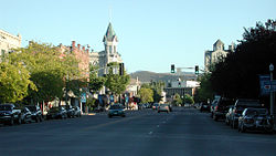 Baker City along I-84 in Oregon, surrounded by sections of Wallowa-Whitman National Forest.
Coordinates: 44°46′36″N 117°49′57″W / 44.77667°N 117.8325°W Country United States State Oregon County Baker Platted 1865[1] Incorporated 1874[1] Government - Mayor Dennis Dorrah[1] Area - Total 6.9 sq mi (17.9 km2) - Land 6.9 sq mi (17.9 km2) - Water 0.0 sq mi (0.0 km2) Elevation 3,451 ft (1,051.9 m) Population (2010) - Total 9,828 - Density 1,424.3/sq mi (549.1/km2) Time zone Pacific (UTC-8) - Summer (DST) Pacific (UTC-7) ZIP code 97814 Area code(s) 541 FIPS code 41-03650[2] GNIS feature ID 1167694[3] Website www.bakercity.com Baker City is a city in and the county seat of Baker County, Oregon, United States.[4] It was named after Edward D. Baker.[5] The population was 9,828 at the 2010 census.
Contents
History
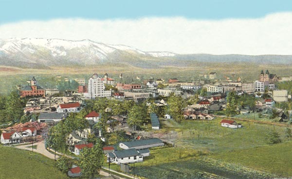
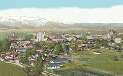 Aerial view, about 1918.
Platted in 1865,[1] Baker City grew slowly in the beginning.[6] A post office was established on March 27, 1866, but Baker City was not incorporated until 1874.[1] The city[1] and county were named in honor of U.S. Senator Edward D. Baker, the only sitting senator to be killed in a military engagement.[7]
The Oregon Short Line Railroad came to Baker City in 1884, prompting growth; by 1900 it was the largest city between Salt Lake City and Portland and a trading center for a broad region.[1] In 1911 the city dropped "City" from its name, but restored it in the late 1980s in recognition of its history and to further encourage tourism.
The Roman Catholic Diocese of Baker City was established on June 19, 1903, after which the Cathedral of Saint Francis de Sales was built in Baker City.[8] In 1918, Baker was the subject of national interest when the 1918 Solar eclipse took place and the U.S. Naval Observatory decided to base their observations here.[9]
Geography
According to the United States Census Bureau, the city has a total area of 6.9 square miles (18 km2), all of it land.
The city is situated in a valley between the Wallowa Mountains to the east and the Elkhorn Mountains, part of the Blue Mountains to the west, with the Powder River running through the center of downtown on its way to the Snake River.
Demographics
Historical populations Census Pop. %± 1870 312 — 1880 1,258 303.2% 1890 2,604 107.0% 1900 6,663 155.9% 1910 6,742 1.2% 1920 7,729 14.6% 1930 7,858 1.7% 1940 9,342 18.9% 1950 9,471 1.4% 1960 9,986 5.4% 1970 9,354 −6.3% 1980 9,471 1.3% 1990 9,140 −3.5% 2000 9,860 7.9% 2010 9,828 −0.3% 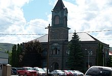 Baker City Hall
As of the census[2] of 2010, there were 9,828 people, 4,212 households, and 2,529 families residing in the city. The population density was 1,424.3 people per square mile (549.1/km²). There were 4,653 housing units at an average density of 674.3 per square mile (259.9/km²). The racial makeup of the city was 94.57% White, 1.12% Native American, 0.53% Asian, 0.44% African American, 0.01% Pacific Islander, 0.97% from other races, and 2.35% from two or more races. Hispanic or Latino of any race were 3.52% of the population.
There were 4,212 households out of which 24.5% had children under the age of 18 living with them, 45.1.2% were married couples living together, 10.5% had a female householder with no husband present, and 40.0% were non-families. 33.8% of all households were made up of individuals and 16.8% had someone living alone who was 65 years of age or older. The average household size was 2.25 and the average family size was 2.85. In the city the population was 23.7% under the age of 19, 5.0% from 20 to 24, 23.0% from 25 to 44, 27.8% from 45 to 64, and 20.5% who were 65 years of age or older. The median age was 44 years. For every 100 females there were 98.9 males. For every 100 females age 18 and over, there were 98.6 males. In 2005, the median income for a household in the city was $29,020, and the median income for a family was $34,790. Males had a median income of $26,638 versus $20,313 for females. The per capita income for the city was $14,179. About 10.7% of families and 16.5% of the population were below the poverty line, including 19.1% of those under age 18 and 14.9% of those age 65 or over.
Arts and culture
Annual cultural events
Baker City hosts many annual festivals, including the Miners' Jubilee on 3rd weekend of July, which celebrates the mining history of the area and the filming of the Lee Marvin and Clint Eastwood film, Paint Your Wagon in the city.[10] The Miners' Jubilee was originally launched in 1934 as the Baker Mining Jubilee, but lapsed after 1941 because of World War II and a declining interest in mining. The event was revived by Richard and Marge Haynes in 1975. The couple organized the celebration for two years before handing it over to the Baker County Chamber of Commerce.[11]
Museums and other points of interest
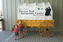 Baker City is home to the National Historic Oregon Trail Interpretive Center.
- Baker Historic District[12]
- Baker City Tower - tallest building in Eastern Oregon[13]
- Crossroads Art Center, in Baker City's former Carnegie library
- Downtown U.S. Bank, featuring a gold display that includes the Armstrong Nugget, weighing 80.4 ounces (2.28 kg)
- Eltrym Historic Theater, a theater that opened on June 27, 1940[14]
- Geiser Grand Hotel[15] - first opened in 1889, now on the National Register of Historic Places
- National Historic Oregon Trail Interpretive Center,[16] established in 1992 as a focal point for the area's tourism[1]
- Oregon Trail Regional Museum[17]
Sports and recreation
The Elkhorn Classic bicycle race is based out of Baker City. The city hosts the Oregon School Activities Association Class 1A girls and boys basketball tournaments every year at Baker High School in March. Baker City hosts the East-West Shrine High School football game at the end of July. The Hell's Canyon Motorcycle Rally is also held in Baker City, in June.
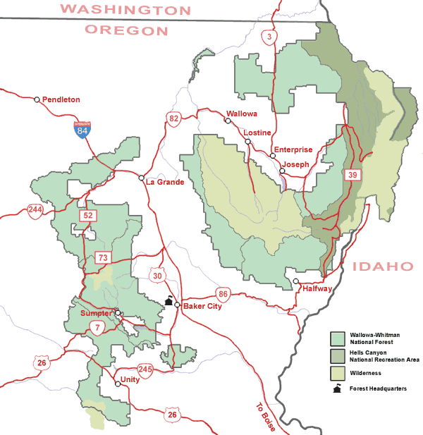
Sections of the Wallowa–Whitman National Forest are to the west and to the northeast of Baker City, which serves as the forest headquarters.
Transportation
Interstate 84 runs along the eastern edge of Baker City, while U.S. Route 30 passes through its downtown area. Oregon Route 7 leaves Baker City to the south to the city of Sumpter and beyond. Oregon Route 86 heads north and east past the National Historic Oregon Trail Interpretive Center and on to the cities of Richland and Halfway.
Baker City is served by the Baker City Municipal Airport.
Baker City is also served by the Huntington Subdivision[citation needed] of the Union Pacific Railroad, originally the Oregon Railway and Navigation Company. Between 1977 and 1997 the city was a regular stop along the former route of Amtrak's Pioneer between Chicago, Salt Lake City, Boise, Portland, and Seattle.
Education
Baker City is served by Baker School District 5J. It includes Baker High School and Baker Middle School.
Baker Middle School was designed by Ellis F. Lawrence and completed in 1917. It is constructed from local tuff and is a stripped classical style. As of 2011 the building is unoccupied and was on the Historic Preservation League of Oregon Most Endangered Places in Oregon 2011 list.[18]
Media
Newspapers
Baker City has two newspapers: the Baker City Herald published on Monday, Wednesday and Friday and The Record Courier published on Thursday.
Radio
Sister cities
Baker City has one sister city[20]
References
- ^ a b c d e f g h Entry for Baker City in the Oregon Blue Book
- ^ a b "American FactFinder". United States Census Bureau. http://factfinder.census.gov. Retrieved 2008-01-31.
- ^ "US Board on Geographic Names". United States Geological Survey. 2007-10-25. http://geonames.usgs.gov. Retrieved 2008-01-31.
- ^ "Find a County". National Association of Counties. http://www.naco.org/Counties/Pages/FindACounty.aspx. Retrieved 2011-06-07.
- ^ "Historic Baker City, Baker County, Oregon". Oregon Genealogy. http://www.oregongenealogy.com/baker/historybc/bakercity.htm. Retrieved 24 October 2011.
- ^ Bailey, Barbara Ruth (1982). Main Street: Northeastern Oregon. Oregon Historical Society. pp. 20, 45. ISBN 0875950736.
- ^ October 21, 1861 - Senator Killed in Battle, from the U.S. Senate website
- ^ In 1952, the name was changed to the Roman Catholic Diocese of Baker.
- ^ Hammond, J.C. (1919). "The Naval Observatory eclipse expedition, June 8, 1918". Popular Astronomy 27 (1). Bibcode 1919PA.....27....1H.
- ^ "Paint Your Wagon filming locations". The Worldwide Guide To Movie Locations. 2006. Archived from the original on 2007-04-30. http://web.archive.org/web/20070430121817/http://movie-locations.com/filmarchive/p/paintyourwagon.html. Retrieved 2007-08-08.
- ^ "“Celebrate 20 years of re-Jubilation". Baker City Herald. 2001. Archived from the original on 2007-09-28. http://web.archive.org/web/20070928192013/http://www.bakercityherald.com/news/results.cfm?story_no=814. Retrieved 2007-08-08.
- ^ Historic Baker City, Oregon
- ^ http://www.bakertower.com/Pages/History.htm
- ^ Eltrym Theater, Baker City Oregon
- ^ Restoration of the Geiser Grand Hotel
- ^ National Historic Oregon Trail Interpretive Center official site from the Bureau of Land Management
- ^ Baker County - Oregon Trail Regional Museum
- ^ "Most Endangered Places 2011 - Baker City Middle School". Historic Preservation League of Oregon. 2011. http://www.historicpreservationleague.org/mep_BakerMiddle.php. Retrieved 5 June 2011.
- ^ "http://www.afa.net/uploadedFiles/Radio/Station%20Listing.pdf" American Family Radio Station Listing
- ^ sister-cities.org, as designated by Sister Cities International
External links
 Media related to Baker City, Oregon at Wikimedia Commons
- Entry for Baker City in the Oregon Blue Book
 Chisholm, Hugh, ed (1911). "Baker City". Encyclopædia Britannica (11th ed.). Cambridge University Press.
Coordinates: 44°46′36″N 117°49′57″W / 44.776721°N 117.832617°W
Municipalities and communities of Baker County, Oregon County seat: Baker CityCities 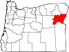
Unincorporated
communitiesAuburn | Bridgeport | Carson | Copperfield | Cornucopia | Dixie | Durkee | Hereford | Homestead | Jimtown | Keating | Lime | Little Alps | McEwen | New Bridge | Oxbow | Pine | Pocahontas | Rock Creek | Salisbury | Sparta | Weatherby | Whitney | Wingville
Ghost towns Bourne | Robinette
Categories:- Baker City, Oregon
- Populated places in Baker County, Oregon
- Cities in Oregon
- County seats in Oregon
- Populated places established in 1866


Wikimedia Foundation. 2010.