- Gilliam County, Oregon
-
Gilliam County, Oregon 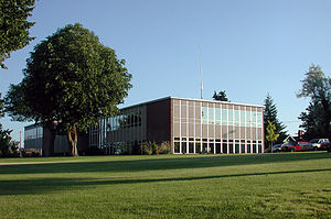
Gilliam County Courthouse in Condon 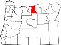
Location in the state of Oregon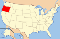
Oregon's location in the U.S.Founded February 25, 1885 Seat Condon Area
- Total
- Land
- Water
1,223 sq mi (3,168 km²)
1,204 sq mi (3,118 km²)
19 sq mi (49 km²), 1.53%Population
- (2010)
- Density
1,871
2/sq mi (.6/km²)Website www.co.gilliam.or.us Gilliam County is a county located in the U.S. state of Oregon. The county was established in 1885 and is named for Cornelius Gilliam, who commanded the forces of the provisional government of Oregon after the Whitman Massacre. In 2010, the population was 1,871. The seat of the county is Condon.
Contents
History
For untold generations, American Indians traversed the county on well-worn trails to reach fishing, hunting, foraging, and trading areas; but had claimed no tribal lands. Many of these trails are still visible in the rangeland. The first non-native people in the area were Americans following the Oregon Trail to the Willamette Valley. In the late 19th century, settlers arrived from the midwestern and eastern United States and Europe to stay and build farms and communities. Many settlers were also part of a larger reverse migration of people who had originally settled in the Willamette Valley.
The Legislative Assembly created Gilliam County on February 25, 1885, from the eastern third of Wasco County after residents complained that they were too far from the county seat in The Dalles. The first county seat was at Alkali, now Arlington. The question of a permanent county seat was placed on general election ballots in 1886, 1888, and again in 1890, when voters chose to move the county seat to Condon, known to early settlers as "Summit Springs." Once the question of the location of the county seat was settled, voters in Gilliam County proved reluctant to provide a courthouse in Condon. The county government operated out of a two-room house until 1903, when the county court appropriated money to construct a courthouse. This courthouse burned down in 1954 and was replaced the following year with the current courthouse.
Economy
Gilliam County is in the heart of the Columbia River Plateau wheat-growing region. The economy is based on agriculture, and wheat, barley and beef cattle are the principal products. Properties are large, with an average farm size of about 4,200 acres (17 km2).
The largest individual employers in the county are two subsidiaries of Waste Management Inc., Chemical Waste Management of the Northwest and Oregon Waste Systems, Inc., who run two regional waste disposal landfills. By levying a fee of $1 a ton, Gilliam County receives enough money to pay the first $500 of the property tax bills of its inhabitants, an amount that covers the full tax bill for almost half of the county inhabitants, as well as funding other county projects.
Hunting, fishing and tourism are secondary industries. Transportation also contributes to the local economy; two major rivers, the John Day and Columbia, cross the area east-to-west, as does Interstate 84. Oregon Route 19 connects the county's major cities north-to-south and provides access to the John Day Valley.
Politics

Though Gilliam County is located in central Oregon, politically it falls in line with the eastern side of the state. The majority of registered voters who are part of a political party in Gilliam County, as well as most counties in eastern Oregon, are members of the Republican Party.[1] In the 2008 presidential election, 58.36% of Gilliam County voters voted for Republican John McCain, while 38.74% voted for Democrat Barack Obama and 2.88% of voters either voted for a Third Party candidate or wrote in a candidate.[citation needed] These numbers show a small but clear shift towards the Democratic candidate when compared to the 2004 presidential election, in which 66.3% of Gilliam Country voters voted for George W. Bush, while 32.5% voted for John Kerry, and 1.2% of voters either voted for a Third Party candidate or wrote in a candidate.[2]
Geography
 Sunrise in Gilliam County
According to the U.S. Census Bureau, the county has a total area of 1,223 square miles (3,167.6 km2), of which 1,204 square miles (3,118.3 km2) is land and 19 square miles (49.2 km2) (1.53%) is water.
Adjacent counties
- Sherman County, Oregon - west
- Wasco County, Oregon - southwest
- Wheeler County, Oregon - south
- Morrow County, Oregon - east
- Klickitat County, Washington - north

Klickitat County, Washington Sherman County 
Morrow County  Gilliam County, Oregon

Wasco County Wheeler County Demographics
Historical populations Census Pop. %± 1890 3,600 — 1900 3,201 −11.1% 1910 3,701 15.6% 1920 3,960 7.0% 1930 3,467 −12.4% 1940 2,844 −18.0% 1950 2,817 −0.9% 1960 3,069 8.9% 1970 2,342 −23.7% 1980 2,057 −12.2% 1990 1,717 −16.5% 2000 1,915 11.5% 2010 1,871 −2.3% [3][4][5] As of the census[6] of 2000, there were 1,915 people, 819 households, and 543 families residing in the county. The population density was 2 people per square mile (1/km²). There were 1,043 housing units at an average density of 1 per square mile (0/km²). The racial makeup of the county was 96.76% White, 0.16% Black or African American, 0.84% Native American, 0.16% Asian, 1.15% from other races, and 0.94% from two or more races. 1.83% of the population were Hispanic or Latino of any race. 18.2% were of German, 18.1% American, 12.6% English, 12.5% Irish and 5.3% Scottish ancestry according to Census 2000.
There were 819 households out of which 27.60% had children under the age of 18 living with them, 57.90% were married couples living together, 5.90% had a female householder with no husband present, and 33.60% were non-families. 29.50% of all households were made up of individuals and 12.10% had someone living alone who was 65 years of age or older. The average household size was 2.31 and the average family size was 2.85.
In the county, the population was spread out with 23.20% under the age of 18, 5.40% from 18 to 24, 25.60% from 25 to 44, 26.70% from 45 to 64, and 19.10% who were 65 years of age or older. The median age was 43 years. For every 100 females there were 102.20 males. For every 100 females age 18 and over, there were 96.30 males.
The median income for a household in the county was $33,611, and the median income for a family was $41,477. Males had a median income of $30,915 versus $20,852 for females. The per capita income for the county was $17,659. About 6.70% of families and 9.10% of the population were below the poverty line, including 11.00% of those under age 18 and 6.60% of those age 65 or over.
Communities
Incorporated cities
Unincorporated communities
Shepherds Flat Wind Farm
Main article: Shepherds Flat Wind FarmThe Shepherds Flat Wind Farm is an 845 megawatt (MW) wind farm under construction in Oregon, United States. The project is located in Eastern Oregon in both Morrow and Gilliam counties, near Arlington. Approved in 2008 by state regulators, groundbreaking came in 2009. The wind farm is being built by Caithness Energy using General Electric (GE) 2.5 MW wind turbines, and it will supply electricity to Southern California Edison.
In April, 2011, Google announced they had invested $100 million in the project. The wind farm is estimated to have an economic impact of $16 million annually for Oregon. It is projected to be the largest land-based wind farm in the world when completed in 2012.
See also
References
- ^ "Voter registration by county: March 2009", 10 April 2009 (PDF). Elections Division. Retrieved April 20, 2009.
- ^ "Gilliam County, Oregon". City-Data.Com. Retrieved April 21, 2009.
- ^ http://www.census.gov/population/www/censusdata/cencounts/files/or190090.txt
- ^ http://factfinder2.census.gov
- ^ http://mapserver.lib.virginia.edu/
- ^ "American FactFinder". United States Census Bureau. http://factfinder.census.gov. Retrieved 2008-01-31.
External links
Municipalities and communities of Gilliam County, Oregon Cities 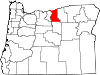
Unincorporated
communitiesCategories:- Oregon counties
- Gilliam County, Oregon
- 1885 establishments


Wikimedia Foundation. 2010.