- Oregon Route 99
-
This article is about OR 99 south of Junction City. For the split routes north of Junction City, see Oregon Route 99E and Oregon Route 99W. For the former U.S. Route, see U.S. Route 99 in Oregon.
Oregon Route 99
Route information Maintained by ODOT Existed: 1972 – present Major junctions South end:  I-5 in Ashland
 OR 66 in Ashland

 OR 62 / OR 238 in Medford
 OR 234 near Gold Hill
 OR 238 / US 199 in Grants Pass
 OR 227 near Canyonville
 OR 42 near Winston
 OR 138 in Roseburg
 OR 38 in Drain
 OR 58 near Eugene

 I-105 / OR 126 in Eugene
 OR 569 in Eugene
 OR 36 near Junction City
North end: 
 OR 99E / OR 99W in Junction City
Highway system Oregon highways
Routes • Highways←  US 97
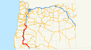
US 97OR 99E →Oregon Route 99 is a state highway that runs between the southern border of Oregon, and the city of Junction City. Oregon Route 99 was formed from parts of the former U.S. Route 99; it shares much of its route with Interstate 5, but much of it is also independent. Between Portland and Junction City, the highway is forked into two routes: Oregon Route 99E and Oregon Route 99W.
Contents
Route description
Oregon Route 99 technically starts at an interchange with Interstate 5 at exit 11, south of Ashland. There it departs from the freeway, running parallel to I-5 as it passes through the cities of Ashland (as Main Street), Talent, Phoenix, and Medford. The highway rejoins I-5 at exit 35, just Northwest of Central Point.
OR 99 departs from I-5 several more times through the mountains of southern Oregon, only to rejoin again a short distance later. Junctions are found in Gold Hill (2nd Ave), Grants Pass, between Myrtle Creek and Sutherlin (crossing I-5 in Roseburg, Oregon), through Drain and Yoncalla, and Cottage Grove and Goshen. These departures serve as business routes for I-5, as Oregon does not have or sign Interstate business routes.
When it reaches Eugene, OR 99 departs from I-5 for a final time. It heads west into downtown, along Franklin Boulevard past the University of Oregon. Downtown, OR 99 is on the 6th and 7th Avenue couplet. (Much of the section in Eugene is co-signed with either Oregon Route 126 or OR 126 Business.) West of downtown it heads north on an expressway alignment, which continues to Junction City. In Junction City, OR 99 ends, as it splits into eastern and western forks.
Highways comprised
OR 99 comprises the following named highways (see Oregon highways and routes) and roads, from south to north:
- The Rogue Valley Highway No. 63;
- Part of the Pacific Highway No. 1 (concurrent with I-5);
- The Gold Hill Spur, which is no longer a state highway;
- The Sams Valley Highway No. 271 (concurrent with OR 234);
- The Rogue River Highway No. 60;
- Part of the Redwood Highway No. 25;
- Part of the Pacific Highway (concurrent with I-5);
- Part of Fifth Street in Canyonville;
- Part of the Tiller-Trail Highway No. 230;
- Part of the Pacific Highway (concurrent with I-5);
- The Myrtle Creek Highway, which is no longer a state highway;
- Part of the Pacific Highway (concurrent with I-5);
- The Dillard Highway, which is no longer a state highway;
- Part of the Coos Bay-Roseburg Highway No. 35 (concurrent with OR 42);
- The Oakland-Shady Highway, which is no longer a state highway (concurrent with OR 138);
- Part of the Pacific Highway (concurrent with I-5);
- The Drain-Yoncalla Highway, which is no longer a state highway;
- Part of the Umpqua Highway No. 45;
- Part of the Pacific Highway (concurrent with I-5);
- The Goshen-Divide Highway No. 226;
- Part of the Pacific Highway (concurrent with I-5); and
- Part of the Pacific Highway West No. 1W.
Major intersections
- Note: OR 99 uses many different highways (see Oregon highways and routes); the milepoint column shows mileage along these highways, not adjusted for equations, with the highway number in front. Not all interchanges on I-5 are shown. For a complete list of interchanges, see the Interstate 5 exit list.
County Location Milepoint[1] Destinations Notes Jackson 63 24.11 I-5 southAshland 63 20.5 OR 66 to I-5 – Lakeview, Klamath FallsMedford 63 5.56  OR 62 east / OR 238 west to I-5 / OR 140 – Rogue Valley Mall, Crater Lake, Jacksonville
63 0.26 Blackwell Road Former US 99 north 63 0.00
1 35.80 I-5 south – MedfordSouth end of I-5 overlap 1 40.82
271Y 3.02 I-5 north – Grants PassNorth end of I-5 overlap 271Y 2.76 Blackwell Road Former US 99 south Gold Hill 271 2.36 OR 234 east – Crater LakeSouth end of OR 234 overlap 271 -0.30
60 14.50 To I-5 (via OR 234 west)North end of OR 234 overlap 60 12.63 I-5 – Medford, Grants PassInterchange Josephine Grants Pass 60 0.18 To I-5 (via Redwood Spur)60 0.00
25 -0.07 US 199 south – Crescent CitySouth end of US 199 overlap 25 -0.94 To I-5 / F StreetFormer Redwood Spur 25 -1.00 E Street Former Rogue River Loop Highway 25 -2.63 Scoville Road Northbound exit and southbound entrance 25 -2.85
1 58.25 I-5 south – MedfordSouth end of I-5 overlap Douglas Canyonville 1 98.31 I-5 north – RoseburgNorth end of I-5 overlap 3rd Street – Days Creek, Crater Lake Former OR 227 south Yokum Road – Riddle 1 101.15 I-5 south – CanyonvilleSouth end of I-5 overlap 1 103.98 I-5 north – Myrtle Creek, RoseburgNorth end of I-5 overlap Pruner Road – Riddle 1 108.27 I-5 south – Grants PassSouth end of I-5 overlap 1 112.28 I-5 north – RoseburgNorth end of I-5 overlap Winston 35 73.37 OR 42 west, Coquille, Coos BaySouth end of OR 42 overlap 35 76.22 OR 42 east to I-5 – Roseburg, Grants PassNorth end of OR 42 overlap I-5 south – Grants PassInterchange Roseburg 138 -0.31 OR 138 west to I-5 – West RoseburgSouth end of OR 138 overlap 138 0.00 OR 138 east (North Umpqua Highway) – Diamond Lake, Crater LakeNorth end of OR 138 overlap Sutherlin To OR 138 / I-5 – Elkton1 140.05 I-5 south – RoseburgSouth end of I-5 overlap; southbound exit and northbound entrance 1 150.51 I-5 north – EugeneNorth end of I-5 overlap Drain 45 50.25 OR 38 west – Ocean Beaches, Reedsport, Coos BaySouth end of OR 38 overlap 45 56.37 Curtin Road – Anlauf, Lorane Former Territorial Highway Anlauf 45 57.33
1 162.39 I-5 south – RoseburgNorth end of OR 38 overlap; south end of I-5 overlap Lane 1 168.37
226 20.05 I-5 north – PortlandNorth end of I-5 overlap; northbound exit and southbound entrance Creswell 226 5.78 Oregon Avenue – Lorane 226 5.74 To I-5 (via OR 222) – Eugene, Roseburg226 0.23 Franklin Boulevard Former US 99 north 226 0.00
18 0.07 OR 58 east (Willamette Highway) – Oakridge, Klamath Falls18 0.31
1 188.57 I-5 south – RoseburgSouth end of I-5 overlap 1 189.87 30th Avenue – South Eugene (OR 225) Former US 99 north Eugene 1 192.27
1W 126.38 I-5 north – PortlandNorth end of I-5 overlap; northbound exit and southbound entrance 1W 126.02 Riverview Street Interchange; no southbound entrance 1W 125.93 


OR 126 Bus. east – SpringfieldInterchange; south end of OR 126 Bus. overlap; southbound exit and northbound entrance; former US 99 south 1W 124.02 To I-105 / I-5 / Coburg Road – SpringfieldInterchange 1W 123.29 I-105 / OR 126 east to I-5 – SpringfieldInterchange; north end of OR 126 Bus. overlap; south end of OR 126 overlap 1W 122.97 Blair Boulevard Former Junction City-Eugene Highway 1W 122.19 OR 126 west – Veneta, Elmira, FlorenceNorth end of OR 126 overlap 1W 118.42 To OR 126 / I-5 / Beltline Highway (OR 569) – Florence, SpringfieldInterchange 1W 111.28 OR 36 – Cheshire, FlorenceJunction City 1W 109.76 1st Avenue to High Pass Road – Santa Clara Former Junction City-Eugene Highway 1W 108.76 OR 99E north / OR 99W north – Albany, Portland, Corvallis, McMinnville-
This list is incomplete; you can help by expanding it.
References
- ^ Oregon Department of Transportation, Public Road Inventory (primarily the Digital Video Log), accessed April 2008
Categories:- State routes in Oregon
- U.S. Route 99
- Transportation in Josephine County, Oregon
- Transportation in Lane County, Oregon
- Transportation in Jackson County, Oregon
- Transportation in Douglas County, Oregon


Wikimedia Foundation. 2010.