- Oregon Route 36
-
For the unsigned Highway 36, see Pendleton-Cold Springs Highway.
Oregon Route 36
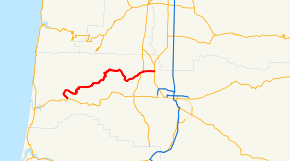
Route information Maintained by ODOT Length: 51.58 mi (83.01 km) Major junctions West end:  OR 126 in Mapleton
 OR 200 in Cheshire
East end:  OR 99 in Junction City
Highway system Oregon highways
Routes • Highways←  OR 35
OR 35OR 37  →
→Oregon Route 36 is an Oregon state highway that runs between the city of Mapleton in the Oregon Coast Range, and the city of Junction City in the Willamette Valley. The highway is officially designated as the Mapleton-Junction City Highway No. 229 (see Oregon highways and routes). The entire route of the highway is located within Lane County.
Contents
Route description
The western terminus of Oregon Route 36 is a junction with Oregon Route 126 in Mapleton. From Mapleton, the route heads due north through the Coast Range, then heads due east, following the course of the Siuslaw River. At the community of Swisshome it departs from the river, passing through the communities of Deadwood and Greenleaf, Triangle Lake, Blachly and Low Pass. As it emerges from the mountains, it passes through the Alderwood State Wayside, and descends into the Willamette Valley. It then passes through the communities of Goldson and Cheshire before ending just south of Junction City at an intersection with Oregon Route 99.
The highway was originally part of U.S. Route 28 and was the primary route between the Oregon Coast and the Eugene area; however, because of its winding nature, it was not suitable for high volumes of traffic. The commercial importance of the highway diminished greatly when a more direct route between Mapleton and Eugene—the present day alignment of Oregon Route 126—was constructed.
Major intersections
- Note: mileposts do not reflect actual mileage due to realignments.
The entire route is in Lane County.
Location Mile[1] Destinations Notes 0.01 OR 126 – Veneta, Eugene, Florence45.95 Elmira, Veneta (OR 200 south) West end of OR 200 overlap 47.41 Territorial Highway (OR 200 north) East end of OR 200 overlap 51.59  OR 99W – Junction City, Eugene
References
- ^ Oregon Department of Transportation, Public Road Inventory (primarily the Digital Video Log), accessed April 2008
External links
Categories:- State routes in Oregon
- Transportation in Lane County, Oregon


Wikimedia Foundation. 2010.