- Oregon Route 200
-
Oregon Route 200
Route information Maintained by ODOT Length: 40.64 mi (65.40 km) Existed: 2002 – present Major junctions South end: Territorial Road at Lane-Douglas County line  OR 126 in Veneta
 OR 36 near Franklin
OR 36 near Bear CreekNorth end:  OR 99W in Monroe
Highway system Oregon highways
Routes • Highways←  US 199
OR 201  →
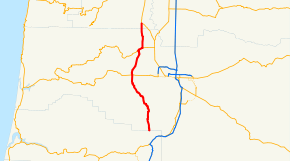
→Oregon Route 200 is an Oregon state highway running from OR 99W at Monroe to the Lane-Douglas County line near Anlauf. OR 200 is composed of most of the Territorial Highway No. 200 (see Oregon highways and routes). It is 40.64 miles (65.40 km) long, in two segments broken by a section of OR 36 and runs north–south.
OR 200 was established in 2002 as part of Oregon's project to assign route numbers to highways that previously were not assigned, and, as of June 2009, was unsigned.
Contents
Route description
OR 200 begins at an intersection with OR 99W in Monroe. It heads south through Bear Creek to an intersection with OR 36, at which point the Territorial Highway overlaps the Mapleton-Junction City Highway No. 229. The concurrency continues west for 1.48 miles (2.38 km) as OR 36, at which point OR 200 heads south through Elmira to Veneta. At Veneta, OR 200 crosses OR 126 and continues south through Crow and Lorane to the Lane-Douglas County line, where it ends. An old section of the Territorial Highway continues south as a Douglas County road to Anlauf, where it ends at an intersection with OR 99.
History
The Territorial Highway is one of Oregon's oldest roads. It can be traced to at least 1851, and by 1947 was referred to in a judicial opinion as the "Old Territorial Highway".
OR 200 was assigned to the remaining part of the Territorial Highway, except that section which is part of OR 36, in 2002.
Major intersections
Milepost City Intersection -0.06 Monroe OR 99W 8.62 Near Bear Creek OR 36 (End North section) 10.10 Near Franklin OR 36 (Begin South section) 19.49 Veneta OR 126 42.08 Near Anlauf End Route OR 200 begins at a negative milepost. The Department of Transportation placed the zero milepost at a highway connection point slightly displaced from the beginning of the route.
Related routes
References
- Oregon Department of Transportation, Descriptions of US and Oregon Routes, http://www.oregon.gov/ODOT/HWY/TRAFFIC/TEOS_Publications/PDF/Descriptions_of_US_and_Oregon_Routes.pdf, page 28.
- Oregon Department of Transportation, Territorial Highway No. 200, ftp://ftp.odot.state.or.us/tdb/trandata/maps/slchart_pdfs_1980_to_2002/Hwy200_1999.pdf
- Stateoforegon.com, Coyote Creek Covered Bridge, http://coveredbridges.stateoforegon.com/bridges/lane/coyote_creek.htm
- Smith v. Williams, 180 Or. 626, 178 P.2d 710 (1947).
Categories:- State routes in Oregon
- Transportation in Lane County, Oregon
- Transportation in Benton County, Oregon


Wikimedia Foundation. 2010.