- Oregon Route 126
-
"McKenzie Highway" redirects here. For the Canadian highway, see Mackenzie Highway.
Oregon Route 126
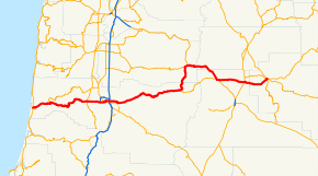
Route information Maintained by ODOT Length: 204.63 mi[citation needed] (329.32 km) Existed: 1972 – present Major junctions West end:  US 101 in Florence
 I-5 in Eugene
 US 20 in Sisters
 US 97 in Redmond
East end:  US 26 in Prineville
Highway system Oregon highways
Routes • Highways←  OR 120
OR 130  →
→Oregon Route 126 is a state highway connecting central, western and coastal Oregon. A short freeway section of Oregon 126 in Eugene and Springfield is co-signed as Interstate 105.
Contents
Route description (East to west)
A business route in the Eugene/Springfield area is also identified.
Prineville to Springfield
Route 126's eastern terminus is in Prineville, with its intersection with U.S. 26. Route 126 travels westward via the Ochoco Highway to Redmond, crossing U.S. Route 97. From Redmond, it continues west along the Sisters-Redmond Highway to the eastern edge of Sisters, where it merges with U.S. Route 20. The highways run co-signed through Sisters to the west end of town and the junction with Oregon Route 242, and then west through the Cascade Mountains to Santiam Junction and the eastern terminus of Oregon Route 22.
Just past Santiam Junction, U.S. Route 20 turns west at Clear Lake (Linn County, Oregon) and crosses the mountains toward the Willamette Valley. Meanwhile, Route 126 continues south along the Clear Lake-Belknap Springs Highway to Belknap Springs and the western terminus of Route 242. From that point, Route 126 veers west as the McKenzie Highway, flanking the McKenzie River for most of its length toward Springfield and Eugene.
Freeway (I-105) section
In east Springfield lies the eastern terminus of Eugene-Springfield Highway No. 227 (see Oregon highways and routes), an east–west freeway through the Eugene-Springfield metropolitan area. Oregon 126 is routed along this freeway for its entire length. West of the Interstate 5 interchange, the freeway is also designated as Interstate 105, a spur of I-5. At this point, I-105 and Route 126 enter Eugene. After two exits and a Willamette River crossing, I-105 reaches its western terminus at Oregon Route 99 (West Sixth Avenue) between Washington and Jefferson streets. The bridge and viaduct carrying the last 1.5 miles of I-105 are known as the Washington-Jefferson Street Bridge.[1]
Business route
Within the Eugene-Springfield area, Oregon 126 has a business loop. At the western terminus of I-105, Route 126 heads west on Sixth Avenue (cosigned with Oregon 99). From that same terminus, Business Route 126 heads east, also cosigned with Route 99, along Seventh Avenue. This route then proceeds through Eugene's downtown core and turns south at an interchange near the Ferry Street Bridge.
After two blocks, Business Route 126/Route 99 turns east again on East Broadway, which becomes Franklin Boulevard at Alder Street. Franklin Boulevard separates the south shore of the Willamette River from the northern edge of the University of Oregon campus.
Past the university campus and surrounding business district, Business Route 126 and Route 99 split. Route 99 joins southbound I-5, while Route 126 continues eastbound through the community of Glenwood. It then crosses the Willamette River and enters the city of Springfield. Business Route 126 continues east through downtown Springfield, eventually rejoining the main stem of Route 126 in the Thurston neighborhood of the city's east end.
Eugene to Florence
At the western terminus of I-105, Oregon 126 turns west and is cosigned with Oregon 99 for a mile and a half. At Garfield Street, the highways separate. Route 126 becomes the Florence-Eugene Highway, proceeding south on Garfield five blocks to West 11th Avenue, which carries the highway out of Eugene toward the Oregon Coast. In west Eugene, Route 126 intersects the western terminus of Oregon Route 569 (Beltline Highway).
The Petersen Tunnel, heading East
Between Eugene and the rural-suburban city of Veneta, Route 126 passes through farmland and crosses the southern portion of Fern Ridge Reservoir, a popular recreation magnet for the area. A Union Pacific Railroad branch line, built to Coos Bay in 1914, parallels Route 126 for much of its length between Eugene and Veneta.
At Veneta, Route 126 begins its ascent into the Coast Range, cresting at milepost 80 on Cougar Pass, elevation 800 ft (240 m). Cougar Pass marks the division point between the watersheds of the Willamette and Siuslaw rivers. As it descends toward the Siuslaw Valley and the coast, Route 126 follows first Wildcat Creek and then the Siuslaw River itself. On this downhill stretch the Petersen Tunnel (completed in 1957) marks the point where the last barrier to a one-hour drive from Eugene to the coast was breached.
At Mapleton and the junction with Oregon Route 36, Route 126 turns sharply to the west. For 14 miles, it follows the Siuslaw to the western terminus of river and road, the coastal community of Florence.
History
In 1926, the route between Florence and Ontario, Oregon was designated as U.S. 28. The Junction City-Florence section of the highway ran roughly along what are now Oregon routes 36 and 126.
In 1937, the same year a new U.S. 99 alignment between Eugene and Junction City opened, U.S. 28 was truncated and its western terminus moved to Glenwood (between Eugene and Springfield).
In 1951, U.S. 28 was eliminated from the federal highway route system. The highway was redesignated U.S. Route 26 between the Oregon-Idaho border and Prineville (and then continuing north and west through Portland to Astoria. The former U.S. 28 section between Prineville and Eugene was then designated U.S. Route 126.
In 1957 the long-awaited direct route between Eugene and the coast, known as "Route F," was completed. The state of Oregon formally named the new route the Eugene-Mapleton Highway, but did not assign a it a route number until 1965, when it became Oregon 126. Federal highway authorities agreed to the duplication as a temporary one, as U.S. 126 would soon disappear under the ongoing elimination of three-digit U.S. routes lying entirely within one state.
In 1972, the federal government dropped U.S. 126 from its highway system. The state of Oregon promptly redesignated the Prineville-Eugene section of the former U.S. route, and the Mapleton-Florence section of Oregon 36, as Oregon 126.
Prior routes
The routes of Oregon 126 and its predecessors have changed numerous times over the years. The original route of U.S. 28 from Florence to Eugene ran through Junction City, and multiplexed with U.S. Route 99 (now Oregon Route 99) from there south to Eugene. The route between Junction City and Brickerville is now Oregon Route 36; the original route of US 28 west of Brickerville is no longer on the state highway system.
In 1972, U.S. 126 was eliminated and Oregon 126 through the Eugene-Springfield area was routed onto a newly-constructed freeway through north and east Springfield, and then the older Interstate 105 at Eugene. The portions of the former U.S. 126 rolling through downtown Springfield and Eugene were designated as the Route 126 business route.[2]
The place where Oregon 126 and its predecessors crosses the Cascade Mountains has changed over the years. Originally, the highway was routed over McKenzie Pass, a high mountainous route that frequently was closed in winter due to poor road conditions. In 1962, the Clear Lake Cutoff was constructed between Clear Lake and Belknap Springs, connecting the McKenzie Highway to the Santiam Highway (U.S. Route 20) to the north. U.S. 126 was re-routed over the cutoff and multiplexed with U.S. 20 east over the Cascades to Sisters, where it resumes its original course. The stretch of the McKenzie Highway between Belknap Springs and Sisters is now designated as Oregon Route 242. Route 242 is primarily a scenic route and is not plowed in wintertime.[3]
Proposed expansions
Currently, the route of Oregon Route 126 through western Eugene runs along several surface streets, most notably including West 11th Avenue. This route is well-known in the Eugene area for traffic problems. Several projects have been proposed to deal with this; however, none has met with community approval.
Roosevelt Freeway
The Roosevelt Freeway was a proposed freeway alignment of Route 126 through Eugene, Oregon and its western suburbs. The project was canceled in 1972, largely due to the Oregon freeway revolts.
The freeway was proposed to go north of the current Route 126 alignment along West 11th Avenue, Roosevelt Boulevard and the Willamette River near the Whitaker neighborhood, and connect to the current Interstate 105 just south of the Washington-Jefferson Street Bridge.[4] A proposed eastward extension of the project, the Skinner Butte Freeway, never made it off the drawing board).
The freeway was designed to solve a longstanding traffic issue in Eugene, the inadequacy of West 11th Avenue (a neighborhood arterial) to handle long-haul and commuter traffic. Many commuters, as well as state transportation officials, strongly desired to build the freeway. Plans for the freeway were completed in the mid 1970s, and the state of Oregon had begun buying up property for the right-of-way. A ramp stub currently exists on I-105, where the interchange with the Roosevelt Freeway would have been.
 This ramp stub, as seen from the west side of Skinner Butte, was supposed to provide access to the canceled Roosevelt Freeway from Interstate 105.
However, the freeway proved to be unpopular with Eugene residents, due to its impact on existing neighborhoods and riverfront access. In 1978, the so-called "T-2000" transportation plan was adopted, which effectively killed the Roosevelt Freeway by removing it from the plan's list of transportation projects. The plan did call for an east–west corridor through west Eugene, but for a scaled-down version. The mothballed West Eugene Parkway, a non-freeway route on a similar alignment, was seen by supporters and critics alike as an implementation of these plans.
West Eugene Parkway
The West Eugene Parkway, or WEP, was a proposed re-alignment of Oregon 126 through the western parts of Eugene and its suburbs. Route 126 runs through west Eugene along several surface streets, including West 11th Avenue, which is well-known for its traffic problems. The proposed route, a limited-access expressway with some at-grade intersections and one interchange, would have run north of the current West 11th alignment, terminating at the western terminus of the Sixth-Seventh Avenue couplet carrying Oregon 99 through west Eugene. The project proved to be highly controversial. In July 2006, ODOT suspended work on it, and recommended a no-build alternative to the Federal Highway Administration.[5]
Transportation planners argued that the new route is necessary to fight traffic congestion in Eugene and its western suburbs, and that the highway would facilitate traffic and growth in the year 2025.
Opponents to the parkway have several reasons for their objection:
- The route is not needed; further road construction is a symptom of urban sprawl and better land use planning is the solution
- The route will encourage further development and urban sprawl in west Eugene
- World petroleum supplies will likely be in decline long before the road would be completed, and therefore modest fixes to existing roads would be sufficient
- The proposed route will disrupt environmentally-sensitive areas, including wetlands near the proposed alignment
- The parkway is just a resurrection of the old Roosevelt Freeway proposal (canceled in 1972), and calling the proposed project a "parkway" is deceptive
- The proposed route will just dump more traffic in Eugene's downtown core. The project fails the federally mandated "independent utility" test, and is thus illegal, because public transportation projects must be self-standing, according to federal law. It is alleged that construction of the parkway will raise traffic on Sixth and Seventh Avenues to unacceptable levels, requiring construction of a new highway through downtown. If such a design element was included in the current plan, such inclusion would likely lead to its cancellation).
- Funds spent on the project (officially $169 million) would be better spent on other improvements to the area transportation network.
On June 18 and 19, 2001, the City of Eugene, Lane County, the Oregon Department of Transportation (ODOT), the Federal Highway Administration (FHWA) and the Bureau of Land Management (BLM), among others, held a two-day "West Eugene Charette" to discuss the future of the project. Most participants were supporters of the highway, but at the end of the conference agreed to select the "no build" option. This consensus was not implemented, although ODOT and FHWA continued to spend millions, for a time, on the Environmental Impact Statement.[6]
Supporters, and the government agencies involved in the planning of the project, pointed to the fact that the parkway proposal has been approved by city voters in two referendum elections, most recently in 2001. Opponents note that the election was 51 to 49, and that proponents claimed "The Money Is There" when selling the project. The official price tag for the WEP was $88 million in 2001, but a 2004 estimate by local and state governments predicts the cost is really $169 million. Few WEP proponents support tax increases to pay for the highway.
On October 26, 2005, the Eugene City Council voted 5-4 to withdraw the City's support for the project, although the City of Eugene has continued its agreement with ODOT to assume responsibility for maintaining part of the road. The city also owns property for the parkway that has not yet been transferred to the BLM nature preserve for conservation and restoration.
In July 2006, ODOT withdrew its support of the project, effectively killing it.
Major intersections
- Note: mileposts do not reflect actual mileage due to realignments.
County Location Mile[7] Destinations Notes Lane Florence 0.02 US 101 – Yachats, Newport, Reedsport, Coos BayMapleton 14.40  OR 36 – Swisshome, Junction City
Veneta 46.92 Territorial Highway (OR 200) – Elmira, Veneta 52.69
0.00West end of formerly proposed West Eugene Parkway Eugene 3.10  To I-5 / OR 99 / Beltline Highway (OR 569) – Santa Clara, Springfield
122.26 OR 99 northWest end of OR 99 overlap 123.10 Blair Boulevard Former Junction City-Eugene Highway 123.30 Jefferson Street – Lane County Fairgrounds 123.37
0.00 OR 99 south (OR 126 Bus. east) – Downtown EugeneEast end of OR 99 overlap West end of freeway and I-105 0.89 Delta Highway to Beltline Highway (OR 569) Signed as exit 1 1.96 Country Club Road, Coburg Road – Downtown Eugene Signed as exit 2 3.50 I-5 – Roseburg, SalemEast end of I-105; westbound exit for I-5 north is signed as exit 4B Springfield 4.67 Springfield City Center (OR 528) 6.09 Mohawk Boulevard 7.51 42nd Street – Marcola Western Access to Weyerhaeuser Complex 9.05 52nd Street Eastern Access to Weyerhaeuser Complex 9.05 East end of freeway 9.97
6.23


 OR 126 Bus. west – Springfield City Center
54.97
19.81 OR 242 east (Scenic Route) – McKenzie Pass
Linn 0.00
71.69 US 20 west – Sweet Home, Lebanon, AlbanyWest end of US 20 overlap Santiam Junction 74.90  OR 22 – Detroit, Salem
Deschutes Sisters 100.12
Z92.03 OR 242 west (Scenic Route) – McKenzie Pass93.07 US 20 east – Bend, BurnsEast end of US 20 overlap 107.43 Cline Falls Highway Interchange Redmond 111.94
-0.06 US 97 – Madras, Portland, Bend, Klamath FallsCrook Powell Butte 6.84 Bozarth Road Former Powell Butte Highway Prineville 17.92 O'Neil Highway (OR 370) – O'Neil, Terrebonne 18.16 US 26 – Madras, Portland, Prineville City Center, John DayReferences
- ^ Interstate-Guide.com
- ^ "Interstate 105". oroads.com. http://www.angelfire.com/or3/oroads/roads/i105/index.html. Retrieved 2007-10-02.
- ^ East of McKenzie Bridge
- ^ Eugene's 1967 Highway Plan
- ^ Northwest Region- Region 2 West Eugene Parkway Project
- ^ Report on WEP charette
- ^ Oregon Department of Transportation, Public Road Inventory (primarily the Digital Video Log), accessed April 2008
External links
- O'Roads: Interstate 105
- Wetlands: West Eugene Transportation, Land and Neighborhood Design Solutions, an alternative to the $200 million WEP
- West Eugene Parkway controversy
Auxiliary routes of Interstate 5 California: 105 • 105 (former) • 205 • 305 (unsigned) • 405 • 505 • 605 • 805 • 905 (future) — Oregon: 105 • 205 • 305 (unbuilt) • 405 • 505 (unbuilt) — Washington: 205 • 405 • 605 (unbuilt) • 705
Interstate Highways in Oregon Current Cancelled Categories:- State routes in Oregon
- Transportation in Lane County, Oregon
- Transportation in Deschutes County, Oregon
- Transportation in Linn County, Oregon
- Transportation in Jefferson County, Oregon
- Transportation in Crook County, Oregon
- Deschutes National Forest
- Willamette National Forest


Wikimedia Foundation. 2010.