- Oregon Route 99E Business
-
Oregon Route 99E Business

Route information Business route of OR 99E Maintained by ODOT Length: 8.71 mi (14.02 km) Major junctions South end: 

 I-5 / OR 99E / OR 22 in Salem OR 22 in Salem
North end: I-5 in KeizerHighway system Interstate 305 (Oregon) redirects here. For the hidden route in California, see Interstate 80 Business (Sacramento, California)Oregon Route 99E Business is a business route through Salem, Oregon for Oregon Route 99E, which bypasses downtown via Interstate 5. A portion of this highway was originally planned to be a freeway, signed as Interstate 305; however the proposed freeway was cancelled after community opposition.
Contents
Route description
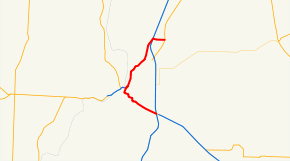
The northern end of OR 99E business is at an intersection with OR 99E north of the Salem area. 99E Business runs east for approximately 0.25 miles (0.4 km) to an interchange with I-5 and the Salem Parkway (officially, the Salem Highway #72) near Keizer. 99E Business then runs southwest along the Parkway for appxoimately 3 miles (5 km), then turns south along the Commercial Street/Liberty Street couplet for another 2 miles (3 km). In downtown Salem, the highway skirts downtown along Front Street, where it interchanges with and shares an alignment with Oregon Route 22. OR 99E/OR 22 then leave downtown via Pringle Parkway, skirting the southern edge of the Willamette University campus, then via a pair of ramps interchange with Mission Street. The highways then head southeast for 2.4 miles (4 km) until an interchange with I-5 and OR 99E. This interchange marks the end of OR 99E Business; OR 22 continues to the east along the North Santiam Highway.[1]
History
The route which is now the Salem Parkway was originally planned to be a freeway (the Salem Freeway #65), which was to be signed as Interstate 305. After originally being conceived only as a four-mile (6 km) spur of Interstate 5 into downtown Salem, the I-305 project was modified and expanded by about 2.34 miles (3.77 km) to include a new bridge across the Willamette River to meet Oregon Route 22, providing increased access to Polk County.[2] While local opposition cancelled the freeway, the Salem Parkway was later built as an undivided expressway.
The original alignment of Oregon Route 99E through Salem came from the south off I-5 onto Commercial Street and left to the north on Portland Road to cross I-5. At some point, possibly when the Salem Parkway opened north of downtown, Oregon Route 99E was rerouted onto I-5 around Salem, and its old route south of downtown, along with the Salem Parkway and Chemawa Road north of downtown, became Oregon Route 99E Business. Later Oregon Route 99E Business was moved onto Route 22 southeast from downtown.
Future plans
ODOT and the City of Salem are considering building an additional bridge across the Willamette River, north of the current Marion and Center Street bridges (which carry OR 22 across the river, and are the only river crossings for motor vehicles in the city). The exact location and alignment of this proposed new bridge and its connecting routes is presently under study, but generally, the routes being considered would connect to OR 99E Business at or near the southern end of the Salem Parkway on the river's eastern shore, and provide access to both OR 22 and Oregon Route 221 on the western side. Such a route would be similar to that proposed for I-305.[3]
References
- ^ "Descriptions of US and OR Routes". Oregon Department of Transportation. http://www.oregon.gov/ODOT/HWY/TRAFFIC/TEOS_Publications/PDF/Descriptions_of_US_and_Oregon_Routes.pdf.
- ^ Oregon Department of Transportation, Interstate 50th Anniversary: The Story of Oregon's Interstates, accessed April 14, 2006 (PDF)
- ^ "Salem River Crossing". Oregon Department of Transportation. http://www.salemrivercrossing.org/. Retrieved 2007-10-03.
Auxiliary routes of Interstate 5 California: 105 • 105 (former) • 205 • 305 (unsigned) • 405 • 505 • 605 • 805 • 905 (future) — Oregon: 105 • 205 • 305 (unbuilt) • 405 • 505 (unbuilt) — Washington: 205 • 405 • 605 (unbuilt) • 705
Interstate Highways in Oregon Current Cancelled 305 • 505Categories:- State routes in Oregon
- U.S. Route 99
- Transportation in Marion County, Oregon
- Keizer, Oregon
- Transportation in Salem, Oregon


Wikimedia Foundation. 2010.