- Interstate 605
Infobox road
state=CA
type=I
route=605
alternate_name=San Gabriel River Freeway
section=619
maint=Caltrans 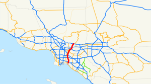
length_mi=27.40
length_round=2
length_ref=cite web|url=http://www.fhwa.dot.gov/reports/routefinder/table2.cfm|title=Route Log and Finder List - Interstate System: Table 2|publisher=FHWA|accessdate=2007-10-07]
history=1940s as a state highway, 1964 as a number [ [http://www.scvresources.com/highways/la_tidbits.htm Los Angeles Highways] ]
direction_a=South
terminus_a=jct|state=CA|I|405|SR|22 in Seal Beach
junction=jct|state=CA|SR|91 near Lakewood jct|state=CA|I|5 near Norwalk jct|state=CA|I|10 near El Monte
direction_b=North
terminus_b=jct|state=CA|I|210|road=Huntington Dr. in Irwindale
previous_type=I
previous_route=580
next_type=I
next_route=680
commons=categoryInterstate 605 (I-605 - also referred to as "The 605") is a major north-south interstate
freeway of about 27 miles (43 km) in length located in theGreater Los Angeles Area inSouthern California . It is officially known as the San Gabriel River Freeway, one of the fewSouthern California freeways not named after a city along its route. The freeway, running from Seal Beach to Irwindale, derives its name from the San Gabriel River that it parallels for most of its alignment.This route is part of the
California Freeway and Expressway System [http://www.leginfo.ca.gov/cgi-bin/displaycode?section=shc&group=00001-01000&file=250-257 CA Codes (shc:250-257)] ] .Route description
The southern terminus of I-605 is at the San Diego (I-405) and Garden Grove (State Route 22) Freeways in Seal Beach. From there, it runs roughly north through the
Gateway Cities of theLos Angeles Basin . It then shifts north-northeast, crossing the Whittier Narrows and across theSan Gabriel Valley . I-605 then ends at its junction with theFoothill Freeway , (I-210) in Duarte, a small city located at the foothills of theSan Gabriel Mountains .I-605 follows most of the length of the San Gabriel River from the San Diego Freeway in Seal Beach to the Santa Fe Dam. Typically dry riverbed and flood basins are visible from many portions of the route, especially near the northern terminus. Also, the freeway features an
HOV lane for carpools of two or more people throughout most of the route.Signs along I-605's entrances and freeway junctions do not include destinations (
control cities ) such as "Seal Beach" or "Irwindale", but simply read "NORTH" or "SOUTH" — a rarity in Southern California. In place of control cities, a simple "THRU TRAFFIC" designation is used.Route 605 from Route 405 to Route 10 is known as the San Gabriel River Freeway, as named by Senate Bill 99, Chapter 1101 in 1967. [cite book | url=http://www.dot.ca.gov/hq/tsip/hseb/products/Named_Freeways.pdf | title=2007 Named Freeways, Highways, Structures and Other Appurtenances in California | publisher=
Caltrans | pages=62 | accessdate=2007-03-28];Other names
*The I-605/I-105 interchange is known as the Joe A. Gonsalves Memorial Interchange, as named by Assembly Bill 96, Chapter 129 in 2001. Gonsalves became the first person of Portuguese ancestry to become a member of theCalifornia State Legislature in 1962 ["Ibid." 97, 185]History
Interstate 605 began construction and the first section was opened in 1964 from Interstate 405 to Interstate 10. The newest section (extension to the Interstate 210) was opened in 1971 was originally signed as SR 243. Originally it was planned as I-13 running from Interstate 5 to I-15. There are plans to extend it to SR 1 further south in Orange County, however due to strong community opposition this is unlikely that the alignment will ever be built. [http://www.cahighways.org/505-805.html#605]
Exit list
:"Note: Except where prefixed with a letter,
postmile s were measured in 1964, based on the alignment as it existed at that time, and do not necessarily reflect current mileage. The numbers reset at county lines; the start and end postmiles in each county are given in the county column."References

Wikimedia Foundation. 2010.