- Interstate 710
-
For the once-proposed I-710 in Arizona, see Interstate 710 (Arizona).
Interstate 710
Long Beach Freeway 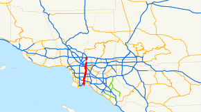
Route information Defined by S&HC § 622 Maintained by Caltrans Length: 23 mi[citation needed] (37 km) History: 1930s as highway, 1964 as a number (SR 7), 1983-1984 as an interstate (I-710)[1] Section 1 South end: Desmond Bridge to Terminal Island Major
junctions: I-405 in Long Beach
 I-105 in Lynwood
 I-5 in Commerce
 I-10 in Monterey Park
North end: Valley Boulevard in Alhambra Section 2 South end: California Boulevard in Pasadena North end: 
 SR 134 / I-210 in Pasadena
Highway system Auxiliary route of the Interstate Highway System
Main • Auxiliary • BusinessState highways in California(list • pre-1964)
History • Unconstructed • Deleted • Freeway • Scenic←  I-680
I-680I-780  →
→Interstate 710 (I-710 - colloquially referred to as "The Seven-Ten") is a major north–south interstate freeway running for 23 miles (37 km) through Los Angeles County, California. Officially known as the Long Beach Freeway, it runs north from Long Beach to Alhambra following the course of the Los Angeles River for most of its route, rarely wandering more than a few hundred feet from the riverbed. South of SR 1 in Long Beach, I-710 is officially part of the Seaside Freeway.[2]
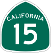
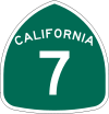
Also called the Los Angeles River Freeway prior to November 18, 1954,[3] I-710 has been planned since its inception to run all the way north to Pasadena, but the construction of the segment from Alhambra to Pasadena through South Pasadena has been delayed for several decades due to community opposition. Prior to 1983, the road was not an Interstate, although it was built to Interstate standards.[citation needed] Until 1964 it was State Route 15, but it was renumbered to State Route 7 in the 1964 renumbering because of the existence of Interstate 15, and to I-710 in 1983.
This route is part of the California Freeway and Expressway System.[4]
Contents
Route description
The southern terminus of the freeway presently signed as Interstate 710 is at Ocean Boulevard in Long Beach. From there, the Long Beach Freeway follows the course of the Los Angeles River to Atlantic Boulevard in the city of Bell. 710 then travels roughly due north, east of Downtown Los Angeles, to its current northern terminus at Valley Boulevard (just north of Interstate 10) in Alhambra, just east of the Los Angeles community of El Sereno.
Near its southern terminus, 710 actually separates into three spur freeways. The first spur carries the Long Beach Freeway designation heading toward Downtown Long Beach and becomes Shoreline Drive after the 6th and 9th Street exits, while the Interstate 710 designation continues on N. Harbor Scenic Drive up to an interchange with Ocean Boulevard. The second spur heads down S. Harbor Scenic Drive after the interchange to the eastern piers of the Port of Long Beach and the Queen Mary. The third spur heads west down Ocean Boulevard, which carries the Interstate 710 designation over Gerald Desmond Bridge onto Terminal Island, where the interstate designation eventually terminates.
There is however a part of the 710 in Pasadena that is constructed to freeway standards, extending from California Boulevard north to the Foothill (I-210)/Ventura (Hwy 134) freeway interchange. But the route designation on this freeway stub is unsigned, and is instead marked if it were merely freeway entrance and exit ramps to and from 210.
History

 1964 – 1985
1930 to 1965
Legislative Route 167 was defined in 1933 to run from San Pedro east to Long Beach and north to Monterey Park.[5] An extension was added in 1947, taking it north to Pasadena.[6] State Route 15 was signed in 1934 along the section of Legislative Route 167 from Pacific Coast Highway (State Route 3, later U.S. Route 101 Alternate, now State Route 1) in Long Beach north to Garvey Avenue (U.S. Route 99, replaced by Interstate 10) in Monterey Park. The original pre-freeway alignment ran along Los Robles Avenue (Pasadena) and Atlantic Boulevard.[1][7]The freeway replacement of SR 15/LR 167 was built from 1953 to 1965.[8] The whole route of LR 167, including the proposed extensions west to San Pedro and north to Pasadena, was renumbered State Route 7 in the 1964 after it was decommissioned from portions of San Diego Freeway which is now Interstate 405 state highway renumbering, as the number 15 conflicted with Interstate 15. In 1965 the route was truncated to State Route 1 in Long Beach; the part from SR 1 south and west to State Route 47 was deleted, and the rest from SR 47 west to State Route 11 (now Interstate 110) became part of SR 47.
1965 to present
The section of Long Beach Freeway was built from 1954 to 1975. The Long Beach Freeway was approved as a chargeable interstate in September 1983, and the Long Beach Freeway changed out the SR 7 signs with Interstate 710 in 1984. It was added shortly after the Harbor Freeway went up changing out the SR 11 signs with Interstate 110 in 1981.[9] The short stub in Pasadena was built in 1975, along with the adjacent sections of Interstate 210 and State Route 134.[8]
The section from SR 1 south and west to SR 47 was re-added to the legislative definition at some point. The existing freeway from SR 1 south to Ocean Boulevard was taken over by the state on August 25, 2000 in a trade with the City of Long Beach for former State Route 103 north of SR 1.[10] The rest of the defined route, west on Ocean Boulevard to SR 47, is still locally maintained.
Future
I-710 Corridor Project
The explosive growth of cargo volumes handled at the ports of Los Angeles and Long Beach has added an enormous amount of truck traffic to the Long Beach Freeway, since it is the most direct route between the port complex and the railyards in Vernon and East Los Angeles, as well as the Pomona and San Bernardino freeways that connect Los Angeles to railyards in San Bernardino and Colton. The freeway's pavement has been badly damaged as a result, since it was not designed to carry nearly as large of a load of truck traffic. It has also become a major source of air pollution, emanating from diesel-fueled trucks idling in rush hour traffic congestion and giving cities along its route some of the worst air quality in already smoggy Southern California.[11] In response, an Environmental Impact Statement/Environmental Impact Report is currently being conducted to analyze possible significant improvements to I-710 between the ports of Long Beach and Los Angeles and the Pomona Freeway (SR-60).[12]
The South Pasadena Gap
Overview
The planned segment from Alhambra to Pasadena through South Pasadena has been subject to legal battles and has not been built yet. Because of these disputes, the freeway's northern terminus has been Valley Boulevard since the 1960s. However, a short unsigned freeway does exist in Pasadena, heading south from the interchange of Interstate 210 and State Route 134 to California Boulevard.
As a result of the route's incomplete condition, freeway signs are inconsistent in their identification of the northbound Long Beach Freeway's destination, with some indicating Pasadena as a control city and others identifying Valley Boulevard as the freeway's terminus. For example, approaching I-710 from State Route 60 (Pomona Freeway) in East Los Angeles, westbound traffic is given Valley Boulevard as the destination for northbound I-710, while eastbound traffic is given a destination of Pasadena. Even signs at the interchange with Interstate 105 show Pasadena as the destination for northbound I-710.
This signage suggests that Caltrans still fully expected to extend I-710 to Pasadena at that time, decades after the original proposals for the route through South Pasadena were defeated. Currently, traffic headed for Pasadena on I-710 is redirected to Interstate 10 (San Bernardino Freeway) eastbound by signs at the interchange between the two routes in Monterey Park. These signs identify both Pasadena and San Bernardino as control cities for the eastbound San Bernardino Freeway, although it does not actually pass through Pasadena. Rather, traffic destined for the city is directed to take State Route 19 (Rosemead Boulevard) northbound from its junction with I-10 (about 6 miles (9.7 km) east of the Long Beach Freeway) to reach Pasadena. In reality, however, most traffic from northbound I-710 is forced onto Fremont Avenue in Alhambra and South Pasadena, and the Pasadena Freeway (State Route 110).
The failure to complete the Long Beach Freeway—combined with the failure to complete the Glendale Freeway, which would have provided another alternate route to downtown Los Angeles—has contributed to severe traffic congestion in northeastern Los Angeles and the northwestern San Gabriel Valley. As a result of the gap through South Pasadena, there are no completed north–south freeways in the twelve-mile-long heavily populated area between Interstate 5 (Golden State Freeway) and Interstate 605 (San Gabriel River Freeway). Pro- and anti-710 lobbies have heavily debated whether finishing I-710 would alleviate any of the San Gabriel Valley's traffic congestion, or merely displace it from surface streets to the freeway.
Historic plans
The original plans for the unbuilt segment through South Pasadena had the freeway run parallel to Atlantic Boulevard in Alhambra and Los Robles Avenue in San Marino and Pasadena. However, opposition to this route by the people of Alhambra and San Marino resulted in an alternate routing that skirted Alhambra to the west and bisected South Pasadena. Subsequent opposition to the rerouted project by residents of South Pasadena and the Los Angeles district of El Sereno, and the resulting litigation, have prevented Caltrans from completing the northernmost leg of the route.
Current plans
Currently, Caltrans is researching the possibility of using advanced tunneling technologies to build the Long Beach Freeway under South Pasadena without disturbing the residential neighborhoods on the surface, similar to other tunnels through similarly sensitive cities like Versailles in France. The proposed twin 4.5-mile-long tunnels would be the longest in the United States, but are small compared with others around the world.
South Pasadena's government has grudgingly conceded that it may assent to such a project. However, it is unclear whether this option would be financially feasible. Caltrans has indicated that the South Pasadena real estate that it owns along the original 710 right-of-way, which has appreciated several hundred percent in real terms since its acquisition in the mid-1960s, would currently command a sufficiently high price to pay for the state's share of the tunnel.
Between January and May 2009, Caltrans conducted soil samples for the tunneling project in the Pasadena area.
If the segment is eventually completed, the Long Beach Freeway and the Foothill Freeway (Interstate 210) would form a continuous route around Los Angeles from Long Beach northwards through Pasadena, beyond the Verdugo Mountains via the Crescenta Valley, across the sparsely populated hills in Sunland-Tujunga and finally joining Interstate 5 at Newhall Pass at the northern end of the San Fernando Valley. Interstate 210 from Newhall Pass to Pasadena was expanded to eight lanes in anticipation of this.
Exit list
Note: Except where prefixed with a letter, postmiles were measured on the road as it was in 1964, and do not necessarily reflect current mileage.
The entire route is in Los Angeles County.
Location Postmile
[13][14][15]Exit[16] Destinations Notes Long Beach  SR 47 south (Vincent Thomas Bridge) – San Pedro
Continuation beyond Navy Way Navy Way At-grade intersection; south end of SR 47 overlap  SR 47 north / SR 103 north / Willow Street – Pier A
North end of SR 47 overlap Pier T Avenue – Piers S T Gerald Desmond Bridge over Cerritos Channel 4.96 Port of Long Beach Piers A-J Northbound exit and southbound entrance; south end of state maintenance 5.46 1A Piers F-J, Queen Mary (Harbor Scenic Drive) Southbound exit and northbound entrance 5.98 1B Pico Avenue – Piers B-E Southbound exit and northbound entrance 6.06 1C Downtown Long Beach, Aquarium (Long Beach Freeway, Shoreline Drive) Southbound left exit and northbound entrance 6.38 1D Anaheim Street Signed as exit 1 northbound 6.88 2  SR 1 (Pacific Coast Highway)
7.89 3 Willow Street Signed as exits 3A (east) and 3B (west) 9.07 4 Wardlow Road Southbound exit and northbound entrance 9.41 4 I-405 (San Diego Freeway) – San Diego, Santa MonicaFormer SR 7 10.82 6 Del Amo Boulevard Signed as exits 6A (east) and 6B (west) northbound 12.01 7 Long Beach Boulevard Signed as exits 7A (south) and 7B (north) southbound 12.89 8A Artesia Boulevard Northbound exit and southbound entrance 12.97 8  SR 91 (Artesia Freeway, Gardena Freeway) – Riverside, Redondo Beach
Signed as exits 8A (east) and 8B (west) northbound and the opposite southbound Compton 13.95 9 Alondra Boulevard – Compton Signed as exits 9A (east) and 9B (west) southbound Paramount R14.98 10 Rosecrans Avenue Lynwood R15.69 11A I-105 (Century Freeway) – Norwalk, El SegundoSigned as exit 11 northbound 11B Martin Luther King Jr. Boulevard Southbound exit and entrance South Gate 16.99 12 Imperial Highway – Lynwood Signed as exits 12A (east) and 12B (west) southbound 18.44 13 Firestone Boulevard Former SR 42 Bell 19.73 15 Florence Avenue – Bell 21.92 17A Atlantic Boulevard, Bandini Boulevard Signed as exits 17A (north/east) and 17B (south/west) northbound Commerce 22.45 17B Washington Boulevard – Commerce Signed as exit 17C northbound 23.28 18A I-5 north (Santa Ana Freeway) – Los AngelesNorthbound exit and southbound entrance 23.28 18 I-5 south (Santa Ana Freeway) – Santa AnaSouthbound exit and northbound entrance Los Angeles 23.77 19 Whittier Boulevard, Olympic Boulevard Signed as exit 18B northbound; former SR 72 24.47 20A 3rd Street Signed as exit 20B northbound 24.63 20B  SR 60 (Pomona Freeway) – Pomona, Los Angeles
Signed as exit 20A northbound 24.97 20C Cesar Chavez Avenue Monterey Park 26.38 21 Ramona Boulevard Northbound exit and southbound entrance 26.50 22 I-10 (San Bernardino Freeway) – Los Angeles, San Bernardino, PasadenaSigned as exits 22A (west) and 22B (east) southbound Alhambra T27.48 23 Valley Boulevard At-grade intersection Gap in route Pasadena T30.95 Columbia Street At-grade intersection T31.76 California Boulevard At-grade intersection South end of freeway T32.11 Del Mar Boulevard Southbound exit and northbound entrance T32.45 Colorado Boulevard – Pasadena Southbound exit and northbound entrance R32.72 SR 134 west (Ventura Freeway) – VenturaNorthbound exit and southbound entrance R32.72 I-210 east (Foothill Freeway) – San BernardinoNorthbound exit and southbound entrance R32.72 I-210 west (Foothill Freeway) – San FernandoNorthbound exit and southbound entrance 1.000 mi = 1.609 km; 1.000 km = 0.621 mi
Concurrency terminus • Closed/Former • Incomplete access • UnopenedSouth Harbor Scenic Drive spur (exit 1A)
Note: Except where prefixed with a letter, postmiles were measured on the road as it was in 1964, and do not necessarily reflect current mileage.
The entire route is in Long Beach, Los Angeles County.
Postmile Destinations Notes Queen Mary Southbound exit and northbound entrance Harbor Scenic Drive, Harbor Plaza – Piers H-J Southbound exit and northbound entrance Harbor Plaza – Port of Long Beach, Piers F-G Southbound exit only Downtown Long Beach (Queensway Bridge) Northbound exit and entrance Queensway Drive Northbound exit and entrance Pico Avenue – Piers F-G No northbound exit Downtown Long Beach (Ocean Boulevard) Northbound exit only  I-710 north (N. Harbor Scenic Drive) – Pasadena
Northbound exit and southbound entrance 1.000 mi = 1.609 km; 1.000 km = 0.621 mi Shoreline Drive spur (exit 1C)
Note: Except where prefixed with a letter, postmiles were measured on the road as it was in 1964, and do not necessarily reflect current mileage.
The entire route is in Long Beach, Los Angeles County.
Postmile Destinations Notes Pine Avenue (Shoreline Drive) – Convention Center, Shoreline Village Continuation beyond Queensway Bridge Queen Mary, Events Park, Cruise Ships (Queensway Bridge) At-grade intersection Golden Shore, Catalina Landing Southbound exit and entrance Ocean Boulevard Northbound exit and entrance Shoreline Drive Northbound U-turn Pine Avenue, Broadway – Long Beach Civic Center Southbound exit and northbound entrance 6th Street east – Downtown Long Beach Southbound exit and northbound entrance 9th Street, Anaheim Street – Port of Long Beach Northbound exit and southbound entrance I-710 north (Long Beach Freeway) – PasadenaNorthbound exit and southbound entrance 1.000 mi = 1.609 km; 1.000 km = 0.621 mi References
- ^ a b California Highways: Interstate 710
- ^ "Relating to the Seaside Freeway", 1959 House Resolution No. 144, p. 3502: "That the California Highway Commission is requested to declare the added portion of Route 167 which will connect the Harbor Freeway and the Long Beach Freeway to be a freeway, to be known as the Seaside Freeway..."
- ^ California Department of Transportation, 2007 Named Freeways, Highways, Structures and Other Appurtenances In California (PDF)
- ^ CA Codes (shc:250-257)
- ^ California Highways: Chronology of California Highways 1933-1946
- ^ California Highways: Chronology of California Highways 1947-1962
- ^ 1942 Gousha Los Angeles map
- ^ a b January 1, 2006 California Log of Bridges on State Highways
- ^ California Highways: State Route 7
- ^ Caltrans - District 7: A Closer Look At 2000 Achievements (PDF)
- ^ The Life and Death of Great American Freeways: The 710 Case Study by John Dutton
- ^ "I-710 Corridor Project Overview". Los Angeles County Metropolitan Transportation Authority. http://www.metro.net/projects/i710_corridor/710_overview/. Retrieved 2011-07-16.
- ^ California Department of Transportation, State Truck Route List (XLS file), accessed February 2008
- ^ California Department of Transportation, Log of Bridges on State Highways, July 2007
- ^ California Department of Transportation, All Traffic Volumes on CSHS, 2005 and 2006
- ^ California Department of Transportation, California Numbered Exit Uniform System, I-710 Northbound and I-710 Southbound, accessed February 2008
External links
- The 710 Freeway Fighters
- Friends of Southern California's Highways
- The Life and Death of Great American Freeways: The 710 Case Study by John Dutton
- WestCoastRoads: Interstate 710
Auxiliary routes of Interstate 10 California: 110 • 110 (former) • 210 • 710 — Arizona: 410 (unbuilt) • 510 (former) • 710 (unbuilt) — Texas: 110 • 410 • 610 — Louisiana: 110 • 210 • 310 • 310 (unbuilt) • 410 (unbuilt) • 410 (unbuilt) • 510 • 610 • 910 (unsigned) — Mississippi: 110 • 310 (proposed) — Alabama: 210 (former) — Florida: 110
Interstate Highways in California Signed Unsigned Business Loops Former Freeways in Greater Los Angeles Radial Hollywood (US 101/SR 170) • Golden State (I-5) • Antelope Valley (SR 14) • Glendale (SR 2) • Pasadena/Arroyo Seco Pkwy (SR 110) • San Bernardino (I-10) • Pomona (SR 60) • Santa Ana (I-5/US 101) • Laguna (SR 133) • Corona del Mar (SR 73) • Long Beach (I-710) • Seaside (SR 47) • Terminal Island (SR 103) • Harbor (I-110/SR 110) • Marina (SR 90) • Santa Monica (I-10)Circumferential Inland Empire Chino Valley (SR 71) • Foothill (SR 210) • Moreno Valley (SR 60) • Riverside (SR 91) • San Bernardino (I-10/I-215) • I-10 • I-15 • I-215 • SR 259 • SR 330Toll Categories:- Interstate Highways in California
- Transportation in Long Beach, California
- Southern California freeways
- Three-digit Interstate Highways
- Interstate 10
- Roads in Los Angeles County, California
- Unfinished buildings and structures in the United States


Wikimedia Foundation. 2010.