- Pasadena Freeway
Infobox road
state=CA
type=SR
route=110
highway_name=Pasadena Freeway
alternate_name=Arroyo Seco Parkway
maint=Caltrans 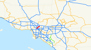
length_mi=8.162
length_ref=
length_round=3
history=Opened in 1940; renamed in 1954
direction_a=South
terminus_a=jct|state=CA|US|101|SR|110 in Los Angeles
direction_b=North
terminus_b=Pasadena
system=Southern California freeways
commons=category
customcommons=California State Route 110The Pasadena Freeway or Arroyo Seco Parkway is the firstfreeway in theU.S. state ofCalifornia , connecting Los Angeles with Pasadena alongside the Arroyo Seco. It is notable not only for being the first, mostly opened in 1940, but for representing the transitional phase between earlyparkway s and modern freeways. Once built to modern standards, it is now known as a dangerous, narrow, outdated roadway. [HAER, pp. 4-5] A 1953 extension brought the south end to theFour Level Interchange indowntown Los Angeles and a connection with the rest of the freeway system.Although the plants in the median have given way to a steel
guard rail , the historic U.S. Route 66 has become State Route 110, and it officially became a "freeway" rather than a "parkway" in 1954, the road remains largely as it was on opening day. The original pavement mostly remains, with thepassing lane colored differently in an attempt to keep drivers in their lanes. [HAER, p. 46] All the bridges built during parkway construction remain, as do four older bridges that crossed the Arroyo Seco before the 1930s. The Pasadena Freeway is often still called the Arroyo Seco Parkway, especially in the context of its historic or scenic designations: a State Scenic Highway,National Civil Engineering Landmark , andNational Scenic Byway .Route description
The six-lane Pasadena Freeway (part of State Route 110) begins at the
Four Level Interchange , a symmetricalstack interchange on the north side ofdowntown Los Angeles that connects the Pasadena (SR 110 north), Harbor (SR 110 south), Hollywood (US 101 north), and Santa Ana (US 101 south) Freeways. The first interchange is with the north end ofFigueroa Street at Alpine Street, and the freeway then meets the north end of Hill Street at a complicated junction that provides access toDodger Stadium . Beyond Hill Street, SR 110 temporarily widens to four northbound and five southbound lanes as it enters the hilly Elysian Park, where the northbound lanes pass through the fourFigueroa Street Tunnels and the higher southbound lanes pass through a cut and over low areas on bridges. One interchange, with Solano Avenue and Amador Street, is located between the first and second tunnels. Just beyond the last tunnel is a northbound left exit and corresponding southbound right entrance for Riverside Drive and the northboundGolden State Freeway (I-5). Immediately after those ramps, the Pasadena Freeway crosses a pair of three-lane bridges over theLos Angeles River just northwest of its confluence with the Arroyo Seco, onerail line on each bank, and Avenue 19 andSan Fernando Road on the north bank. A single onramp from San Fernando Road joins SR 110 northbound as it passes under I-5, and a northbound left exit and southbound right entrance connect to the north segment ofFigueroa Street . Here the original 1940 freeway, mostly built along the west bank of the Arroyo Seco, begins as the southbound lanes curve from their 1943 alignment over the Los Angeles River into the original alignment next to the northbound lanes.Google Maps street maps andUSGS topographic map s, accessed January 2008 via [http://mapper.acme.com/ ACME Mapper] ]As the original freeway begins, it passes under an extension to the 1925
Avenue 26 Bridge , one of four bridges over the Arroyo Seco that predate the parkway's construction. A southbound exit and northbound entrance at Avenue 26 complement the Figueroa Street ramps, and similar ramps connect Pasadena to both directions of I-5. SR 110 continues northeast alongside the Arroyo Seco, passing under the Gold Linelight rail and Pasadena Avenue before junctioning Avenue 43 at the first of manyfolded diamond interchange s that feature extremely tight (right-in/right-out ) curves on the exit and entrance ramps. The next interchange, at Avenue 52, is a normaldiamond interchange , and soon after is Via Marisol, where the northbound side has standard diamond ramps, but on the southbound side Avenue 57 acts as a folded diamond connection. The 1926Avenue 60 Bridge is the second original bridge, and is another folded diamond, with southbound traffic using Shults Street to connect. The 1895Santa Fe Arroyo Seco Railroad Bridge (now Gold Line) lies just beyond, and after that is ahalf diamond interchange at Marmion Way/Avenue 64 with access towards Los Angeles only. After the freeway passes under the 1912York Boulevard Bridge , the pre-parkway bridge, southbound connections between the freeway and cross street can be made via Salonica Street. As the Arroyo Seco curves north to pass west of downtown Pasadena, the Arroyo Seco Parkway instead curves east, crossing the stream into South Pasadena. A single northbound offramp on the Los Angeles side of the bridge curves left under the bridge to Bridewell Street, the parkway's west-sidefrontage road .As they enter South Pasadena, northbound motorists can see a "City of South Pasadena" sign constructed, in the late 1930s, of stones from the creek bed embedded in a hillside. [HAER, pp. 9, 51] This final segment of the Pasadena Freeway heads east in a cut alongside Grevelia Street, with a full diamond at Orange Grove Avenue and a half diamond at
Fair Oaks Avenue . In between those two streets it crosses under the Gold Line for the third and final time. Beyond Fair Oaks Avenue, SR 110 curves north around the east side ofRaymond Hill and enters Pasadena, where the final ramp, a southbound exit, connects to State Street for access to Fair Oaks Avenue. The freeway, and state maintenance, ends at the intersection with Glenarm Street, but the six- and four-lane Arroyo Parkway, now maintained by the city of Pasadena, continues north as a surface road toColorado Boulevard (historic U.S. Route 66) and beyond to Holly Street near the Memorial Park Gold Line station.History
Planning
The Arroyo Seco (Spanish: "dry gulch, or streambed") is an
intermittent stream that carries rainfall from theSan Gabriel Mountains southerly through western Pasadena into theLos Angeles River neardowntown Los Angeles . During the dry season, it served as a fasterwagon connection between the two cities than the all-weather road on the presentHuntington Drive . [HAER, pp. 9-10] The first known survey for a permanent roadway through the Arroyo was made by T.D. Allen of Pasadena in 1895, and in 1897 two more proposals were made, one for a scenicparkway and the other for acommuter cycleway . The latter was partially constructed and opened by Horace Dobbins, who incorporated the California Cycleway Company and bought a six-mile (10 km)right-of-way from downtown Pasadena to Avenue 54 in Highland Park, Los Angeles. Construction began in 1899, and about 1¼ miles (2 km) of the elevated wooden bikeway were opened onJanuary 1 ,1900 , starting near Pasadena'sHotel Green and ending near the Raymond Hotel. The majority of its route is now Edmondson Alley; atoll booth was located near the north end, in the present Central Park. However, due to the end of thebicycle craze of the 1890s and the existingPacific Electric Railway lines connecting Pasadena to Los Angeles, the cycleway did not and was not expected to turn a profit, and never extended beyond the Raymond Hotel into the Arroyo Seco. In the first decade of the 20th century, the structure was torn down, the wood was sold forlumber , [Ann Scheid, Downtown Pasadena's Early Architecture,Arcadia Publishing , 2006, pp. 78-79] Rick Thomas, South Pasadena,Arcadia Publishing , 2007, pp. 60-65] and the Pasadena Rapid Transit Company, a failed venture headed by Dobbins to construct astreetcar line , acquired the right-of-way. [Los Angeles Times , Dash into Pasadena in Twelve Minutes,January 1 ,1909 , p. II1] [HAER, pp. 17-18, 23]Due to the rise of the automobile, most subsequent plans for the Arroyo Seco included a roadway, though they differed as to the purpose: some, influenced by the
City Beautiful movement , concentrated on the park, while others, particularly those backed by theAutomobile Club of Southern California (ACSC), had as their primary purpose a fast road connecting the two cities. The first plan that left the Arroyo Seco in South Pasadena to better serve downtown Pasadena was drawn up by Pasadena City Engineer Harvey W. Hincks in 1916 and supported by the Pasadena Chamber of Commerce and ACSC.Frederick Law Olmsted, Jr. andHarland Bartholomew 's 1924 "Major Street Traffic Plan for Los Angeles", while concentrating on traffic relief, and noting that the Arroyo Seco Parkway would be a major highway, suggested that it be built as aparkway , giving motorists "a great deal of incidental recreation and pleasure". By the mid-1930s, plans for a primarily recreational parkway had been overshadowed by the need to carry large numbers of commuters. [HAER, pp. 18-26]Debates continued on the exact location of the parkway, in particular whether it would bypass downtown Pasadena. In the late 1920s, Los Angeles acquired properties between
San Fernando Road and Pasadena Avenue, and City Engineer Lloyd Aldrich began grading between Avenues 60 and 66 in the early 1930s. By June 1932, residents of Highland Park and Garvanza, who had paidspecial assessment s to finance improvement of the park, became suspicious of what appeared to be a road, then graded along the Arroyo Seco's west side between Via Marisol and Princess Drive. Merchants on North Figueroa Street (then Pasadena Avenue) also objected, due to the loss of business they would suffer from a bypass. Work stopped while the interested parties could work out the details, although, in late 1932 and early 1933, Aldrich was authorized to grade a cheaper route along the east side between Avenue 35 and Via Marisol. To the north, Pasadena and South Pasadena endorsed in 1934 what was essentially Hincks's 1916 plan, but lacked the money to build it. A bill was introduced in 1935 to add the route to the state highway system, and after some debate a new Route 205 was created as a swap for the Palmdale-Wrightwood Route 186, [cite CAstat|year=1935|ch=426|p=288, 1480: "A new route or portion of route is hereby added to the State highway system from Route 165 [Figueroa Street] near Los Angeles River in Los Angeles to Route 161 [Colorado Boulevard] in Pasadena at Broadway Avenue."] [cite CAstat|year=1937|ch=841|p=2361: "Route 205 is from Route 165 near Los Angeles River in Los Angeles to Route 161 in Pasadena at Broadway Avenue."] as the legislature had just greatly expanded the system in 1933, and theCalifornia Highway Commission opposed a further increase. [HAER, pp. 29-34]Construction
To connect the proposed parkway with downtown Los Angeles, that city improved and extended North
Figueroa Street as a four-lane road to theLos Angeles River , allowing drivers to bypass the congestedNorth Broadway Bridge on the existing but underutilizedRiverside Drive Bridge . A large part of the project lay within Elysian Park, and fourArt Deco tunnel s were built through the hills. The first three, between Solano Avenue and the river, opened in late 1931, [Los Angeles Times , By-pass Route Through Elysian Park Tunnels Opened to Automobile Traffic,November 1 ,1931 , p. E1] and the fourth opened in mid-1936, [Los Angeles Times , Shaw Opens New Tunnel,August 5 ,1936 , p. A1] completing the extension of Figueroa Street to Riverside Drive. As with the contemporaryRamona Boulevard east from downtown,grade separation s were mostly built only where terrain dictated. For Figueroa Street, this meant that all crossings except College Street (built several years after the extension was completed [Los Angeles Times , Street Job Bids Will Be Opened,August 15 ,1938 , p. A10] ), where a hill was cut through, were at grade. [ [http://digarc.usc.edu/search/controller/view/chs-m2270.html Aerial view of Chavez Ravine in Los Angeles, looking west, ca. 1940] , accessed via theUniversity of Southern California Libraries Digital Archive] TheFigueroa Street Viaduct , connecting the Riverside Drive intersection with North Figueroa Street (then Dayton Avenue) across theLos Angeles River , opened in mid-1937. [Los Angeles Times , New Bridge Dedicated,July 7 ,1937 , p. A2] Closer to downtown, an interchange was built at Temple Street in 1939. [Los Angeles Times , Traffic Project Work Pushed,May 11 ,1939 , p. A1] [HAER, pp. 27-28, 53-54]Although many South Pasadena residents opposed the division of the city that the parkway would bring, the city's voters elected supporters in the 1936 elections. The state, which had the power to put the road where it wished even had South Pasadena continued to oppose it, approved the route on
April 4 ,1936 . The route used the Arroyo Seco's west bank to near Hough Street, where it crossed to the east and cut through South Pasadena to the south end of Broadway (now Arroyo Parkway) in Pasadena. Another project, theArroyo Seco Flood Control Channel , was built by theWorks Progress Administration before and during construction of the parkway to avoid damages from future floods. A number of state engineers toured East Coast roads in early 1938, including Chicago'sLake Shore Drive , full and modifiedcloverleaf interchange s inMassachusetts andNew Jersey , andRobert Moses 's parkway system inNew York City . The parkway was the first road built in California under a 1939freeway law that allowed access to be completely limited to a number of specified points. Although, in some areas, it was possible to use a standarddiamond interchange , other locations requiredfolded diamond s, or, as the engineers called them, "compressed cloverleafs", where local streets often took the place of dedicated ramps, ending at the parkway with a sharp right turn required to enter or exit. The highway was designed with two 11-12 foot (3.4-3.7 m) lanes and one ten-foot (3.0 m) shoulder in each direction, with the wider inside (passing) lanes paved in blackasphalt concrete and the outside lanes paved in grayPortland cement concrete . The differently-colored lanes would encourage drivers to stay in their lanes. (By mid-1939, the state had decided to replace the shoulders with additional travel lanes for increased capacity; except on a short piece in South Pasadena, these were also paved with Portland cement. So thatdisabled vehicle s could be safely removed from the roadway, about 50 "safety bays" were constructed in 1949 and 1950. [HAER, pp. 60, 69] ) The engineers used adesign speed of 45 miles per hour (70 km/h), superelevating curves where necessary to accomplish this. (The road is now posted at 55 mph/90 km/h. [HAER, p. 68] ) Despite the freeway design, many parkway characteristics were incorporated, such as plantings of mostly native flora alongside the road. [HAER, pp. 34-51]Prior to parkway construction, nine roads and two
rail line s crossed the Arroyo Seco and its valley on bridges, and a number of new bridges were built as part of the project. Only four of the existing bridges were kept, albeit with some changes:National Bridge Inventory database, 2006] the 1925Avenue 26 Bridge , the 1926Avenue 60 Bridge , the 1895Santa Fe Arroyo Seco Railroad Bridge (now part of the Gold Line) near Avenue 64, and the 1912York Boulevard Bridge . The Avenue 43 Bridge would have been kept had theLos Angeles Flood of 1938 not destroyed it. At Cypress Avenue,abutment s and a foundation were built for a roadway, but were not used until the 1960s, when a pedestrian bridge was built as part of theGolden State Freeway (I-5) interchange project. In South Pasadena, seven streets and one rail line were carried over the parkway to keep the communities on each side connected. [HAER, pp. 51-55]Construction on the Arroyo Seco Parkway, designed under the leadership of District Chief Engineer Spencer V. Cortelyou and Design Engineer A. D. Griffin, began with a
groundbreaking ceremony in South Pasadena onMarch 22 ,1938 and generally progressed from Pasadena southwest. The first contract, stretching less than a mile (1.5 km) from Glenarm Street in Pasadena aroundRaymond Hill toFair Oaks Avenue in South Pasadena, and including no bridges, was opened to traffic onDecember 10 ,1938 . A 3.7-mile (6.0 km) section opened onJuly 20 ,1940 , connecting Orange Grove Avenue in South Pasadena with Avenue 40 in Los Angeles. [Los Angeles Times , New Highway Opens Saturday,July 17 ,1940 , p. A12] The remainder in Los Angeles, from Avenue 40 southwest to the Figueroa Street Viaduct at Avenue 22, was opened onDecember 30 ,1940 , in time for theTournament of Roses Parade and Rose Bowl onNew Year's Day . However, the highway through South Pasadena was not completed untilJanuary 30 ,1941 , and landscaping work continued through September. The final cost of $5.75 million, under $1 million per mile, was extremely low for a freeway project because the terrain was favorable for grade separations. [HAER, pp. 55-59]The state began upgrading the four-lane North Figueroa Street extension (then part of Route 165) in October 1940 as a "Southerly Extension" of the parkway, even before the parkway was complete. The at-grade intersection with Riverside Drive was already a point of congestion, and the six lanes of parkway narrowing into four lanes of surface street would cause much greater problems. The two-way Figueroa Street Tunnels and Viaduct were repurposed for four lanes of northbound traffic, and a higher southbound roadway was built to the west. From the split with Hill Street south to near the existing College Street overpass, the four-lane surface road became a six-lane freeway. The extension was designed almost entirely on freeway, rather than parkway, principles, as it had to be built quickly to handle existing traffic. The new road split from the old at the Figueroa Street interchange, just south of Avenue 26, and crossed the
Los Angeles River and the northbound access to Riverside Drive on a new three-lane bridge. Through Elysian Park, a five-lane open cut was excavated west of the existing northbound tunnel lanes, saving about $1 million. The extension, still feeding into surface streets just south of College Street, was opened to traffic onDecember 30 ,1943 , again allowing its use for the New Year's Day festivities. [HAER, pp. 59-64]While the Arroyo Seco Parkway was being built and extended, the region's freeway system was taking shape. The short city-built
Cahuenga Pass Freeway opened onJune 15 ,1940 , [Los Angeles, [http://www.lacity.org/LADOT/TopicsAndTales/Freeway4.pdf Cahuenga Parkway] , accessed January 2008] over a month before the second piece of the Arroyo Seco Parkway was complete. In the next two decades, the Harbor, Hollywood (Cahuenga Pass), Long Beach (Los Angeles River), San Bernardino (Ramona), and Santa Ana Freeways were partially or fully completed to theireponym ous destinations, and others were under construction. [Rand McNally , [http://cahighways.org/maps/1959rmn.jpgLos Angeles and Vicinity] , 1959] The centerpiece of the system was theFour Level Interchange just north ofdowntown Los Angeles , the firststack interchange in the world. Although it was completed in 1949, the structure was not fully used untilSeptember 22 ,1953 , when the short extension of the Arroyo Seco Parkway to the interchange opened. Though the common name used by the public had become "Arroyo Seco "Freeway" over the years, it was officially a "Parkway" untilNovember 16 ,1954 , when theCalifornia Highway Commission changed its name to the Pasadena Freeway. [HAER, pp. 64-67]Post-construction
Despite a quadrupling of traffic volumes, the original roadway north of the Los Angeles River largely remains as it was when it opened in 1940.
Truck s andbus es were banned in 1943, though the bus restriction has since been dropped; this has kept the freeway in good condition and relatively safe, despite its outdated design. This design, state-of-the-art when built, includes tight "right-in/right-out " access with a recommended exit speed of 5 miles per hour (10 km/h) andstop sign s on the entrance ramps; there are noacceleration or deceleration lane s. While the curves are banked for higher speeds, they were designed at half the modern standard. Except for theGolden State Freeway (I-5) interchange near the river, completed in 1962, the few structural changes to the freeway north of the river include the closure of the original southbound exit to Fair Oaks Avenue after its location on a curve proved dangerous and the replacement of shrubs in the 4-foot (1.2 m) median with a steelguard rail . Los Angeles paid for reconstruction of the interchange at Hill Street, south of Elysian Park, in the early 1960s to serve the newDodger Stadium . [HAER, pp. 67-72]When the Arroyo Seco Parkway opened, it became a new alignment of U.S. Route 66, and the old routing via
Figueroa Street andColorado Boulevard became U.S. Route 66 Alternate. [Correspondence between the Division of Highways andAmerican Association of State Highway Officials , transcribed at [http://cahighways.org/065-072.html#066 California Highways: State Route 66] ] The southern extension over the Los Angeles River to downtown Los Angeles also carried State Route 11 (which remained on the old route when US 66 was moved) and U.S. Routes 6 and 99 (which followed Avenue 26 andSan Fernando Road to the northwest). [Division of Highways, [http://www.americanroads.us/citymaps/1944CaStateMapLosAngeles.pngLos Angeles and Vicinity] , 1944] The 1964 renumbering saw US 66 truncated to Pasadena, and SR 11 was moved from Figueroa Street (which became SR 159) to the Pasadena Freeway. [California Highways and Public Works , [http://gbcnet.com/ushighways/history/1964_route_renumbering.pdf Route Renumbering] , March-April 1964, p. 11] Finally, the number was changed to SR 110 in 1981, when SR 11 between San Pedro and theSanta Monica Freeway (I-10) became I-110. [cite CAstat|year=1981|ch=292|p=1418: "Route 110 is from San Pedro to Colorado Boulevard in Pasadena."]The Pasadena Freeway remains the most direct route between downtown Los Angeles and Pasadena despite its flaws; the only reasonable freeway alternate (which trucks must use) is the
Glendale Freeway (SR 2) to the west, which is itself not easily reached by trucks from downtown Los Angeles. The Gold Linelight rail , opened in 2003 over the formerSanta Fe Railway line, provides an alternate mode for commuters. The state legislature designated the original section, north of the Figueroa Street Viaduct, as a "California Historic Parkway" (part of the State Scenic Highway System reserved for freeways built before 1945) in 1993; [cite CAstat|year=1993|ch=179] the only other highway so designated is theCabrillo Freeway (SR 163) in San Diego. TheAmerican Society of Civil Engineers named it aNational Civil Engineering Landmark in 1999, [HAER, p. 4] and it became aNational Scenic Byway in 2002. [U.S. Department of Transportation , [http://www.fhwa.dot.gov/pressroom/fhwa0227.htm U.S. Transportation Secretary Mineta Names 36 New National Scenic Byways, All-American Roads] ,June 13 ,2002 ]Occidental College hosted the "ArroyoFest Freeway Walk and Bike Ride" on Sunday,June 15 ,2003 , closing the freeway to motor vehicles to "highlight several ongoing or proposed projects within the Arroyo that can improve the quality of life for everyone in the area". [ [http://www.arroyofest.org/faq2.htm ArroyoFest Frequently Asked Questions] , accessed January 2008]Major intersections and exit list
:"Note: Except where prefixed with a letter,
postmile s were measured in 1964, based on the alignment as it existed at that time, and do not necessarily reflect current mileage. The entire route is in Los Angeles County."References
*
Historic American Engineering Record (J. Philip Gruen and Portia Lee), [http://www.dot.ca.gov/dist07/aboutdist7/projects/arroyo_seco/pdf/hear_doc.pdf Arroyo Seco Parkway (HAER No. CA-265) written historical and descriptive data] , August 1999External links
*
Historic American Engineering Record : Arroyo Seco Parkway [http://memory.loc.gov/cgi-bin/query/r?ammem/hh:@field(DOCID+@lit(CA2755)) drawings and photos] ; written historical and descriptive data ( [http://www.dot.ca.gov/dist07/aboutdist7/projects/arroyo_seco/hear_doc/html/hear_doc.html HTML] or [http://www.dot.ca.gov/dist07/aboutdist7/projects/arroyo_seco/pdf/hear_doc.pdf PDF] )
*California Department of Transportation : [http://www.dot.ca.gov/hq/LandArch/scenic_highways/photos/p_rte110.htm Route 110 Photo Album]
*National Scenic Byway s: [http://www.byways.org/explore/byways/10246/ Arroyo Seco Historic Parkway - Route 110]
* [http://www.arroyoseco.org/index.htm Arroyo Seco Foundation] (environmental preservation group focused on the Arroyo Seco, including information about the parkway)
* [http://members.cox.net/mkpl/pasadena/pas.html Mark's Highway Page: Pasadena Freeway] (many current and several historic photos)

Wikimedia Foundation. 2010.