- Interstate 110 and State Route 110 (California)
Infobox road
marker_
state=CA
type=I
route=110
name=Interstate 110, State Route 110
alternate_name=Harbor Freeway ,Pasadena Freeway
section=410
maint=Caltrans 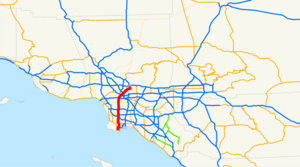
length_mi=31.819
length_ref=
length_round=2
history=Highway in 1930s, number in 1964 (SR 11),1978 -1981 as an interstate [http://cahighways.org/105-112.html#110 California Highways: Interstate 110] ]
direction_a=South
terminus_a=San Pedro
junction=jct|state=CA|I|405 in Carson jct|state=CA|I|10 in Los Angeles
direction_b=North
terminus_b=Pasadena
previous_type=SR
previous_route=109
next_type=SR
next_route=111
commons=categoryRoute 110, consisting of two segments of State Route 110 (SR 110) joined by Interstate 110 (I-110), is a
state highway in theLos Angeles area of theU.S. state ofCalifornia , mostly built tofreeway standards. The entire length of I-110 (which ends at I-10), as well as SR 110 south of theFour Level Interchange with US 101, is the Harbor Freeway, [cite book | url=http://www.dot.ca.gov/hq/tsip/hseb/products/Named_Freeways.pdf | title=2007 Named Freeways, Highways, Structures and Other Appurtenances in California | publisher=Caltrans | pages=71 | accessdate=2007-03-27] and SR 110 north from US 101 to Pasadena is the historicPasadena Freeway , the first freeway in California. At the south end of I-110, SR 110 continues south on Gaffey Street in the Los Angeles neighborhood of San Pedro.This route is part of the
California Freeway and Expressway System . [http://www.leginfo.ca.gov/cgi-bin/displaycode?section=shc&group=00001-01000&file=250-257 CA Codes (shc:250-257)] ]Route description
The Harbor Freeway begins at Gaffey Street in San Pedro, where it then travels mostly due north to the
Santa Monica Freeway (Interstate 10) at a point south of downtown Los Angeles, where it becomes signed as State Route 110. I-110 is primarily within the city limits of Los Angeles, running through the Harbor Gateway, a two-mile (3 km) wide north-south corridor that was annexed by the city of Los Angeles specifically to connect San Pedro, Wilmington and thePort of Los Angeles with the rest the city.In addition, the
Harbor Transitway , a grade-separatedbus andhigh-occupancy vehicle corridor in the median of the 110, runs between State Route 91 (Gardena Freeway ) and the south side of Downtown Los Angeles.The Harbor Freeway, along with the
Long Beach Freeway , are the principal means for freight to get from the port of Los Angeles to rail yards and warehouses further inland. Its interchange with the Santa Monica Freeway is notoriously busy and congested, and the portions bordering Bunker Hill in northwest Downtown Los Angeles are choked with traffic at peak travel times.Notable landmarks and attractions near the Harbor Freeway include the
California State University, Dominguez Hills ;Watts Towers ; Exposition Park (including theLos Angeles Memorial Coliseum ); theUniversity of Southern California ;Staples Center ; and theLos Angeles Convention Center .SR 110 continues north on the Pasadena Freeway to Pasadena.
Notable features
The Harbor Freeway is noted for its elaborate
high-occupancy vehicle lane infrastructure, with HOV lanes elevated above the rest of traffic in many areas. Of particular note is the 7-story ramp that connects the eastboundCentury Freeway to its northbound carpool lanes, offering splendid views of the entireLos Angeles Basin and theSan Gabriel Mountains .History
In the 1924 Major Street Traffic Plan for Los Angeles, a widening of
Figueroa Street to San Pedro as a good road to thePort of Los Angeles was proposed. [Los Angeles Times , City Moves in Figueroa Plan,September 29 ,1926 , p. 13] Progress was slow, [Los Angeles Times , Haste Asked on Figueroa,March 2 ,1936 , p. A8] and in 1933 the state legislature added the entire length to the state highway system as Route 165, an unsigned designation. This route not only extended from San Pedro north to Los Angeles, but continued through the city-builtFigueroa Street Tunnels and along the northern extension of Figueroa Street to Eagle Rock, and then followed Linda Vista Avenue (via an overlap on Route 161 (SR 134) over the Colorado Street Bridge) to Route 9 (now I-210) at the , [http://www.scvresources.com/highways/los_angeles_1939.jpgLos Angeles and Vicinity] , 1939]The state completed the Arroyo Seco Parkway, which had been added to the state highway system in 1935 as Route 205, in early 1941, providing a faster route between SR 11 at Avenue 26 and Pasadena.
Historic American Engineering Record (J. Philip Gruen and Portia Lee), [http://www.dot.ca.gov/dist07/aboutdist7/projects/arroyo_seco/pdf/hear_doc.pdf Arroyo Seco Parkway (HAER No. CA-265) written historical and descriptive data] , August 1999, pp. 34, 57, 65, 67] US 66 was moved to the new route, while SR 11 remained on Figueroa Street and Linda Vista Avenue, the former also becoming a new U.S. Route 66 Alternate. [Correspondence between the Division of Highways andAmerican Association of State Highway Officials , transcribed at [http://cahighways.org/065-072.html#066 California Highways: State Route 66] ] Construction of a freeway to San Pedro was much slower, despite having been in the earliest plans for an integrated system. Initially, the Harbor Parkway was to split at the merge with theVenice Parkway northeast of theUniversity of Southern California , with theEast By-Pass and West By-Pass straddling theLos Angeles Central Business District and rejoining at the split between the Arroyo Seco Parkway andRiverside Parkway south ofDodger Stadium ..)The Harbor Freeway gradually pushed south, opening to Olympic Boulevard on
March 23 ,1954 [Los Angeles Times , New Harbor Freeway Link to Open Today,March 23 ,1954 ] and Washington Boulevard onMay 14 ,1954 . [Los Angeles Times , New Harbor Freeway Section to Open Today,May 14 ,1954 ] OnMarch 27 ,1956 , the highway was extended to 42nd Street, [Los Angeles Times , Brief Ceremonies Open Harbor Freeway Section,March 28 ,1956 , p. 2] and onApril 24 ,1957 it reached temporary [Van Nuys News , Harbor Freeway Section Opened,August 5 ,1958 ] ramps at 88th Place. [Los Angeles Times , Ribbon Cut for New Four-Mile Extension to Harbor Freeway,April 25 ,1957 ] Further extensions were made toCentury Boulevard onJuly 31 ,1958 , [Los Angeles Times , New Harbor Freeway Link Due Thursday,July 28 ,1958 , p. 5] 124th Street onSeptember 24 ,1958 , [Los Angeles Times , Harbor Freeway Sector Opens With Ceremony,September 25 ,1958 , p. B1]Alondra Boulevard (which the county widened to carry the load) onMay 2 ,1960 , [Los Angeles Times , Alondra Blvd. Readied for Freeway Exit Load,May 1 ,1960 , p. CS1] 190th Street onJuly 15 ,1960 , [Los Angeles Times , Two-Mile Harbor Freeway Section Will Open Today,July 15 ,1960 ]Torrance Boulevard onAugust 28 ,1962 , [Los Angeles Times , Harbor Freeway Link to Be Opened Today,August 28 ,1962 , p. A1] and finally Pacific Coast Highway (SR 1) onSeptember 26 ,1962 . [Los Angeles Times , Final Harbor Freeway Link to Be Opened,September 24 ,1962 , p. 25] There it connected with a section that had been open sinceJune 19 ,1956 , from Pacific Coast Highway south to Channel Street. [Van Nuys News , Harbor Freeway Two-Mile Sector Will Open Today,June 19 ,1956 ] Along with theVincent Thomas Bridge toTerminal Island , the final piece in San Pedro opened onJuly 9 ,1970 , completing the Harbor Freeway to its present length. [Lee Bastajian,Los Angeles Times , Vincent Thomas Bridge Link Scheduled to Open in July,May 31 ,1970 , p. CS1] [Long Beach Independent , Dedication Set on Freeway Link to Bridge,July 8 ,1970 ] [Valley News (Van Nuys) , Harbor Freeway Extension to Be Dedicated Today,July 9 ,1970 ]In
December 1978 , the Harbor Freeway was approved as an Interstate Highways by FHWA. In1981 , the SR 11 designation was renumbered as Interstate 110 on the Harbor Freeway, and State Route 110 on thePasadena Freeway . [ [http://www.cahighways.org/105-112.html#110 California Highways (www.cahighways.org): Routes 105 through 112 ] ]I-5 signage
In
2001 , Richard Ankrom, a local artist, who got lost trying to get onto Interstate 5 North from the northbound 110 Freeway because there was no clear official signage labeling access to the 5 North, solved his frustration by covertly modifying one of the overhead signs on the freeway just before the tunnels. Using official government sign specifications, Ankrom fabricated two sign pieces, one being an Interstate marker shield with the number '5' on it, and one with the word "NORTH", and affixed them to the left side of the sign. He performed his modifications in broad daylight, disguised as aCaltrans worker. In that district Caltrans has 3 sign crews, each thinking one of the other two crews did the installation. After nine months, at Ankrom's request, the Los Angeles Downtown News broke the story.Prior to Ankrom's work, the only signage directing motorists to the 5 North off-ramp came at a quarter-mile before the exit, thus forcing many to merge across multiple lanes in a very short distance. The unofficial modifications remain on the sign to this day, after having been inspected by Caltrans to ensure they would not fall off onto the road below. Caltrans is gradually upgrading all California freeway signs to a newer, more reflective form; when this happens on the 110, Ankrom's work may be lost, but the new sign will include "5 North" icons.
Ankrom was never charged, despite statements from officials that his actions were illegal.
It should be noted that an additional "5 North" sign has since been installed over the left lane of the northbound Pasadena Freeway at the entrance to the Figueroa Street Tunnels.
:"See http://www.ankrom.org/freeway_signs.html for a picture of Ankrom's work."
Major intersections and exit list
:"Note: Except where prefixed with a letter,
postmile s were measured in 1964, based on the alignment as it existed at that time, and do not necessarily reflect current mileage. The numbers reset at county lines; the start and end postmiles in each county are given in the county column."The entire route is in Los Angeles County.References
External links
* [http://www.laweekly.com/ink/02/25/a.php A textual account of Ankrom's sign modification]
* [http://www.cahighways.org/105-112.html#110 California Highways - Interstate 110]

Wikimedia Foundation. 2010.