- Ventura Freeway
-
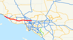
Ventura Freeway

Route information Maintained by Caltrans Major junctions West end:  SR 1 near Ventura
 SR 23 in Thousand Oaks
 I-405 in Sherman Oaks


 US 101 / SR 134 / SR 170 in North Hollywood
 SR 2 in Glendale
To: 
 I-210 / I-710 in Pasadena
Highway system Southern California freeways State highways in California(list • pre-1964)
History • Unconstructed • Deleted • Freeway • Scenic←  SR 133
134 SR 135  →
→The Ventura Freeway is a freeway in southern California running from Ventura to Pasadena. It is the principal east-west route through Ventura County and in the southern San Fernando Valley in Los Angeles County. From Ventura to its intersection with the Hollywood Freeway in the southeastern San Fernando Valley in Los Angeles (the Hollywood Split), it is signed as U.S. Route 101 which was built in the late 1950s and opened on April 5, 1960.[1] East of the Hollywood Freeway intersection, it is signed as State Route 134 which was built by 1971.
Prior to the construction of a new alignment in 1971, the portion east of the Golden State Freeway was known as the Colorado Freeway in reference to nearby Colorado Boulevard, a historic thoroughfare in Pasadena and northeastern Los Angeles.
Contents
Route description
The freeway begins southeast of La Conchita, which alternates between a freeway, an expressway, and an ordinary divided highway previous to this point. East of this point, U.S. 101 is known as the Ventura Freeway. It travels eastward through the citrus orchards and strawberry fields of the Oxnard Plain before ascending a short, steep pass into the Conejo Valley. Continuing eastward through the northern Santa Monica Mountains, it crosses the Ventura/Los Angeles county line before entering the San Fernando Valley. The freeway continues eastward along the valley's southern rim, crossing the 405 and 5 freeways and the Los Angeles River. After passing through Downtown Glendale south of the Verdugo Mountains, it continues along the southern slope of the San Rafael Hills between Glendale and Eagle Rock before entering Pasadena near the Arroyo Seco and terminating at the Foothill Freeway.
The Ventura Freeway suffers from severe congestion. Its intersection with the San Diego Freeway, in Sherman Oaks, is consistently rated[by whom?] as one of the five most congested interchanges in the nation.[citation needed] Where it meets the Hollywood Freeway at the Hollywood Split junction, it is also notably congested. During events at the Rose Bowl, the freeway's eastern portions often resemble a parking lot.
The east-west geographical alignment of the Ventura Freeway and the overall north-south (Washington-to-California) designation of U.S. 101 on freeway signs can be confusing to visitors; the same freeway entrance can often be signed as "101 North" and "101 West"; this is most common in the San Fernando Valley.[citation needed]
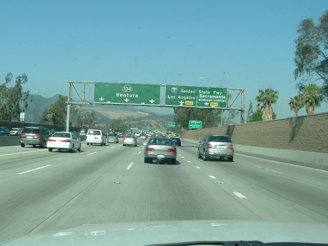
California State Route 134
 Westbound SR 134 at I-5 in Glendale.
State Route 134 is part of the California Freeway and Expressway System.[2]
The road is the main connector from the San Fernando Valley and points north to the San Gabriel Valley and points east. Presently, future Interstate 710 dead-ends at California Blvd and is signed as State Route 710. Residents of South Pasadena have blocked efforts to extend Interstate 710 north to California Boulevard from its current end at Valley Boulevard north of Interstate 10 near the Alhambra/Los Angeles city limit. Signs on SR 134 and I-210 refer to the SR 710 stub in Pasadena as TO State Route 110, because exiting left from the Route 710 stub onto California Blvd and turning right on Arroyo Parkway will take you directly to SR 110, which is Pasadena's only direct freeway link to Downtown Los Angeles.
The Interstate 5 offramp at Colorado St. is actually old SR 134, and there are still mileposts that refer to it as such. Old SR 134 followed Colorado St. through Glendale and Colorado Boulevard in Eagle Rock to the ramp connecting Colorado Boulevard and Figueroa Street to the Ventura Freeway. Old SR 134 continued onto the ramp and then onto what is presently the Ventura Freeway to Orange Grove Boulevard in Pasadena. The Colorado Boulevard/Figueroa Street ramps plus the segment of freeway between the ramps and just east of Orange Grove Boulevard were previously known as the Colorado Freeway.
History
The interchange of SR 134 and Interstate 5 is dedicated "Gene Autry Memorial Interchange". Autry's Museum of the American West is located near the interchange in Griffith Park.
In popular culture
The group America had a top 10 hit in 1972 with the song "Ventura Highway" which the group said was about their dreams of moving to Southern California while living in Nebraska.
The song "A Sorta Fairytale" by Tori Amos begins with the line "On my way up north, up on the Ventura". Later in the song, Amos writes of the "Things you said that day up on the 101."
Michael Jackson wrote the song Billie Jean while driving down the Ventura Freeway.[3]
A dog, named Terry, who played Toto in the 1939 film, The Wizard of OZ, was buried in 1945 somewhere beneath today's Ventura Freeway.
Legal definition
The Ventura Freeway is Routes 101 and 134 from Route 5 to the Santa Barbara County line.[4] This does not include the portion of Route 134 between Route 5 and Route 210 even though local usage extends the name over this portion of freeway. Starting at the 210 junction in Pasadena, highway signs indicate "Ventura" as the destination.
 Sign marking the "Screaming Eagles Highway"
Assembly Concurrent Resolution 54, Chapter 85 in 2003 also designated Route 101 in Ventura County as the "Screaming Eagles Highway".[5] This honors the 101st Airborne Division of the United States Army, which formed on July 23, 1918 and subsequently has been involved in every major war that the United States has participated in since then.[6]
Exit list
- Note: Except where prefixed with a letter, postmiles were measured in 1964, based on the alignment as it existed at that time, and do not necessarily reflect current mileage. The numbers reset at county lines; the start and end postmiles in each county are given in the county column.
This exit list proceeds from east to west, since the majority of the freeway is the north-south US 101.
County Location Postmile
[7][8][9]Exit
[10]Destinations Notes Los Angeles
LA 134 R13.34-0.00
101 11.75-38.19Pasadena R13.34 I-210 east (Foothill Freeway) – San BernardinoEastbound exit and westbound entrance Fair Oaks Avenue, Marengo Avenue Eastbound exit and westbound entrance R13.34 13B I-210 west (Foothill Freeway) – San FernandoEastbound exit and westbound entrance R13.34 13B  To SR 110 (SR 710 south) / Del Mar Boulevard, California Boulevard
R12.97 13A Colorado Boulevard, Orange Grove Boulevard Former SR 248 See State Route 134 Los Angeles 0.86 1D Cahuenga Boulevard – Hollywood Signed as exit 1 eastbound; no westbound entrance 0.51 1C Lankershim Boulevard – North Hollywood Westbound exit and eastbound entrance 0.35 Vineland Avenue No westbound exit 134 0.00
101 11.751B SR 170 north (Hollywood Freeway) – SacramentoWest/northbound exit and east/southbound entrance West/north end of SR 134; east/south end of US 101 overlap US 101 south (Hollywood Freeway) – Los AngelesEast/southbound exit and west/northbound entrance 11.83 13A Tujunga Avenue Southbound exit and northbound entrance 12.85 14 Laurel Canyon Boulevard – Studio City 13.88 15 Coldwater Canyon Avenue 14.89 16 Woodman Avenue 15.91 17 Van Nuys Boulevard 16.94 18 Sepulveda Boulevard Northbound exit and southbound entrance 17.17 19A I-405 (San Diego Freeway) – Santa Monica, Sacramento17.50 19B Haskell Avenue No southbound entrance 18.61 20 Hayvenhurst Avenue Northbound exit and southbound entrance 19.22 21 Balboa Boulevard – Encino 20.23 22 White Oak Avenue 21.25 23 Reseda Boulevard 22.25 24 Tampa Avenue 23.26 25 Winnetka Avenue – Woodland Hills 24.31 26A De Soto Avenue, Serrania Avenue Signed as exit 26 southbound 24.85 26B Canoga Avenue Northbound exit and southbound entrance 25.34 27  SR 27 (Topanga Canyon Boulevard) / Ventura Boulevard
Signed as exits 27A (north) and 27B (south) northbound 25.76 27C Shoup Avenue Northbound exit and southbound entrance 26.45 28 Fallbrook Avenue Southbound exit only 26.86 28 Woodlake Avenue Northbound exit and entrance 27.36 29 Mulholland Drive, Valley Circle Boulevard Calabasas 28.29 30 Parkway Calabasas 31.06 32 Las Virgenes Road – Malibu Canyon 31.92 33 Lost Hills Road Agoura Hills 32.79 34 Liberty Canyon Road 33.69 35 Chesebro Road – Agoura Hills 35.04 36 Kanan Road 36.18 38 Reyes Adobe Road Westlake Village 37.54 39 Lindero Canyon Road Ventura
VEN 0.00-R43.62Thousand Oaks 0.70 40 SR 23 south (Westlake Boulevard)South end of SR 23 overlap 1.62 41 Hampshire Road 3.02 43A Rancho Road Signed as exit 43B northbound 3.11 43B SR 23 north (Moorpark Freeway) – FillmoreNorth end of SR 23 overlap; signed as exit 43A northbound 4.06 44 Moorpark Road – Thousand Oaks 5.05 45 Lynn Road 6.19 46 Ventu Park Road – Newbury Park 7.02 47A Rancho Conejo Boulevard, Borchard Road Signed as exits 47A (Rancho Conejo Boulevard) and 47B (Borchard Road) northbound 7.89 47B Wendy Drive – Newbury Park Signed as exit 47C northbound Camarillo 10.74 50 Camarillo Springs Road – Camarillo Grove County Park 12.30 52 Santa Rosa Road, Pleasant Valley Road 13.75 53A Flynn Road, Dawson Drive 13.85 53B  SR 34 (Lewis Road)
14.80 54 Carmen Drive – Camarillo 15.89 55 Las Posas Road 17.75 57 Central Avenue Oxnard 19.17 59 Del Norte Boulevard 20.08 60 Santa Clara Avenue, Rice Avenue 21.01 61 Rose Avenue 22.01 62A  SR 232 (Vineyard Avenue) – Oxnard
22.73 62B SR 1 south (Oxnard Boulevard)South end of SR 1 overlap 63A Wagon Wheel Road Southbound exit only Ventura R23.45 63B Johnson Drive – Montalvo Signed as exit 63 northbound R24.65 64 Victoria Avenue – Channel Islands Harbor 25.97 65 Telephone Road 26.39 66A  SR 126 east (Santa Paula Freeway) – Santa Paula
Signed as exit 66 southbound; no southbound entrance 26.72 66B Main Street (US 101 Bus. north) – Ventura No southbound exit 28.45 68 Seaward Avenue 29.45 69 Vista del Mar Drive, Sanjon Road Northbound exit and southbound entrance 30.15 70A California Street, Ventura Avenue 30.91 70B  SR 33 north (Ojai Freeway) – Ojai
31.50 71 Main Street (US 101 Bus. south) – Ventura Southbound exit and northbound entrance R32.70 72 State Beaches (SR 1 north) North end of SR 1 overlap; northbound exit and southbound entrance R38.98 78 Seacliff (SR 1 south) South end of SR 1 overlap T40.61 North end of freeway 1.000 mi = 1.609 km; 1.000 km = 0.621 mi
Concurrency terminus • Closed/Former • Incomplete access • UnopenedOn State Route 134
- Note: Except where prefixed with a letter, postmiles were measured in 1964, based on the alignment as it existed at that time, and do not necessarily reflect current mileage.
The entire route is in Los Angeles County.
Location Postmile
[7][8][9]Exit
[11]Destinations Notes Los Angeles 0.00 1A US 101 north (Ventura Freeway) – VenturaWestbound exit and eastbound entrance 0.00 1B SR 170 north (Hollywood Freeway) – SacramentoWestbound exit and eastbound entrance Vineland Avenue Eastbound exit and entrance only 0.51 1C Lankershim Boulevard – North Hollywood Westbound exit and eastbound entrance 0.86 1D Cahuenga Boulevard Signed as exit 1 eastbound; no westbound entrance Burbank 1.82 2 Pass Avenue – Burbank Eastbound exit only 2.11 2 Hollywood Way No eastbound exit 2.90 3 Bob Hope Drive, Buena Vista Street Los Angeles 3.81 4 Forest Lawn Drive 4.81 5A Victory Boulevard Eastbound exit and westbound entrance Glendale R5.47 5B  I-5 south (Golden State Freeway) – Los Angeles
Signed as exit 5 westbound R5.47 5 I-5 north (Golden State Freeway) – Sacramento, Burbank AirportEastbound exit is via exit 5A R6.18 6 San Fernando Road R6.57 7A Pacific Avenue R6.96-
R7.137B Central Avenue, Brand Boulevard R7.87 8 Glendale Avenue R8.81 9A Harvey Drive Signed as exit 9B eastbound R8.96 9B SR 2 (Glendale Freeway)Signed as exit 9A eastbound Los Angeles R11.44 11 Figueroa Street, Colorado Boulevard Figueroa Street was former SR 159 south; Colorado Boulevard was former SR 248 east; westbound exit and eastbound entrance for Colorado Boulevard only Pasadena R12.36 12 San Rafael Avenue, Linda Vista Avenue Linda Vista Avenue was former SR 159 north R12.97 13A Colorado Boulevard, Orange Grove Boulevard Colorado Boulevard was former SR 248 west R13.34 13B I-210 west (Foothill Freeway) – San FernandoEastbound exit and westbound entrance; former SR 118 west R13.34 13B Del Mar Boulevard, California Boulevard (SR 710 south) to SR 110 southNo exit number westbound Fair Oaks Avenue, Marengo Avenue Eastbound exit and westbound entrance I-210 east (Foothill Freeway) – San BernardinoEastbound exit and westbound entrance 1.000 mi = 1.609 km; 1.000 km = 0.621 mi
Concurrency terminus • Closed/Former • Incomplete access • UnopenedSee also
- Colorado Street
References
- ^ Kevin Starr, Golden Dreams: California in an Age of Abundance, 1950-1963 (New York: Oxford University Press, 2009), p. 3.
- ^ CA Codes (shc:250-257)
- ^ Moonwalk (1988), p. 79
- ^ 2007 Named Freeways, Highways, Structures and Other Appurtenances in California. Caltrans. p. 78. http://www.dot.ca.gov/hq/tsip/hseb/products/Named_Freeways.pdf. Retrieved 2007-03-28.
- ^ Ib. at 76
- ^ http://www.cahighways.org/097-104.html#101
- ^ a b California Department of Transportation, State Truck Route List (XLS file). Retrieved February 2008.
- ^ a b California Department of Transportation, Log of Bridges on State Highways, July 2007
- ^ a b California Department of Transportation, All Traffic Volumes on CSHS, 2005 and 2006
- ^ California Department of Transportation, California Numbered Exit Uniform System, US-101 Northbound and US-101 Southbound. Retrieved February 2008.
- ^ California Department of Transportation, California Numbered Exit Uniform System, SR-134 Eastbound and SR-134 Westbound. Retrieved February 2008.
External links
- California @ WestCoastRoads - State Route 134
- Caltrans: Route 134 highway conditions
- California Highways: SR 134
Freeways in Greater Los Angeles Radial Hollywood (US 101/SR 170) • Golden State (I-5) • Antelope Valley (SR 14) • Glendale (SR 2) • Pasadena/Arroyo Seco Pkwy (SR 110) • San Bernardino (I-10) • Pomona (SR 60) • Santa Ana (I-5/US 101) • Laguna (SR 133) • Corona del Mar (SR 73) • Long Beach (I-710) • Seaside (SR 47) • Terminal Island (SR 103) • Harbor (I-110/SR 110) • Marina (SR 90) • Santa Monica (I-10)Circumferential Inland Empire Chino Valley (SR 71) • Foothill (SR 210) • Moreno Valley (SR 60) • Riverside (SR 91) • San Bernardino (I-10/I-215) • I-10 • I-15 • I-215 • SR 259 • SR 330Toll Categories:- Southern California freeways
- Roads in Ventura County, California
- Roads in Los Angeles County, California
- U.S. Route 101
- State highways in California
- Juan Bautista de Anza National Historic Trail
- Transportation in the San Fernando Valley


Wikimedia Foundation. 2010.