- California State Route 14
Infobox road
state=CA
type=SR
route=14
alternate_name=Antelope Valley Freeway, Aerospace Highway
section=314
maint=Caltrans 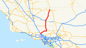
length_mi=118.38
length_ref= [http://www.dot.ca.gov/hq/structur/strmaint/brlog2.htm January 1, 2006 California Log of Bridges on State Highways] ]
length_round=2
established=1964 renumbering (from US 6) [http://cahighways.org/009-016.html#014 California Highways: State Route 14] ]
direction_a=South
terminus_a=Jct|state=CA|I|5 near Santa Clarita
junction=Jct|state=CA|SR|138 in Palmdale
Jct|state=CA|SR|58 near Mojave
direction_b=North
terminus_b=Jct|state=CA|US|395 near Inyokern
previous_type=SR
previous_route=13
next_type=I
next_route=15
commons=categoryState Route 14 is a north-south
state highway largely in theMojave Desert of theU.S. State ofCalifornia , also known as the "High Desert", just east of the crest of the Sierra Nevada in its northern part. It connects U.S. Route 395 in Inyokern to Interstate 5Golden State Freeway in Santa Clarita. With US 395 it connects the western part ofGreater Los Angeles with such places asReno, Nevada . While its southern part runs through the suburbanized and rural canyon areas that can have heavy commuter traffic, its northern section generally affords an attractive, stark view of the Sierra Nevada mountain range. It is in mostly desert terrain, so those who travel it should make the appropriate precautions for travel upon it, especially in the thinly-settled portions north of Mojave during the hot summers.This route is part of the
California Freeway and Expressway System [http://www.leginfo.ca.gov/cgi-bin/displaycode?section=shc&group=00001-01000&file=250-257 CA Codes (shc:250-257)] ] .Route description
The freeway begins in the
Santa Susana Mountains at theNewhall Pass interchange by splitting from theGolden State Freeway (Interstate 5) and proceeding in a northerly direction. Forming the eastern boundary of the city of Santa Clarita along its route, it continues to the northeast and crosses the westernSan Gabriel Mountains via the canyon of the seasonal Santa Clara River. After entering theAntelope Valley , it turns due north, crossing theCalifornia Aqueduct and passing through Palmdale and Lancaster. In the Antelope Valley, SR 14 runs concurrently with SR 138 from Palmdale to north of Lancaster. It continues across the Los Angeles/Kern County line and passes through Rosamond and to the west ofEdwards Air Force Base before the freeway terminates south of Mojave. In the town of Mojave, SR 14 runs along the former alignment of SR 58 before it was rerouted onto a newly built bypass running north and east of the town. SR 14 intersects with the SR 58 bypass of Mojave before it passes throughRed Rock Canyon State Park and the city of Ricardo. SR 14 continues north toward U.S. Route 395 in Inyokern, much of its routing as anexpressway . Towards its northern terminus, SR 14 runs concurrently with State Route 178 near the town of Freeman. At its northern terminus, SR 14 merges with US 395 as it turns into an expressway heading north to BishopCite map | publisher=Thomas Brothers | title=California Road Atlas and Driver's Guide | year=2000 | page=80,89,90] Cite map | publisher=Rand McNally | title=The Road Atlas | year=2008 | page=15] .History
Prior to 1975
Route 14, known as the Antelope Valley Freeway south of the community of Mojave, is the designation for old U.S. Route 6 between US 395 and Interstate 5 after California truncated US 6 at Bishop in 1963. Route 14 was also once used on the length of State Route 91 from Hermosa Beach to Anaheim along Artesia Bl and Lincoln Ave until 1964. The former routing south of and in Mojave is still known as
Sierra Highway (Sierra Highway is also signed as "unrelinquished" State Route 14U in Santa Clarita). North of Mojave, State Route 14 is a segment of the trans-continentalMidland Trail . As part of the former transcontinental US 6, non-freeway segments are also known as theGrand Army of the Republic Highway. The earliest section is completed in 1963 and the newest section is completed in 1975. Its first section, from just east ofSolemint Junction toRed Rover Mine Road was completed in 1963. Further portions in the intercanyon areas of Acton to Soledad Pass (this part of historical Saugus is now referred to asSanta Clarita and Canyon Country) were completed by 1965. By 1966 the freeway was complete as far north as Avenue P-8 in Palmdale. The completed freeway route to Mojave was finished by 1972. Before the Antelope Valley Freeway was constructed, Sierra Highway was generally primarily used, and today remains a prime alternate route.1975 to present
It passes through Palmdale, Lancaster, and Rosamond, all of which have grown rapidly beginning in
1983 . It is co-routed with Route 138 from Palmdale Boulevard (138 East) in Palmdale to Avenue D (138 West) north of downtown Lancaster. The route also intersects with the new Route 58 bypass north of downtown Mojave, as well as Route 178's west and east legs north of Red Rock Canyon.This is an unfinished route, as the definition in the California Streets and Highways Code states that the route begins at Pacific Coast Hwy (PCH), near Sunset Blvd. in the Pacific Palisades area of Los Angeles and even though there is no right of way purchased there. Temescal Canyon Drive seems to be the actual south end of the route, but the wide road leading inland from PCH dead-ends in the Presbyterian Conference Grounds on the north side of Sunset Blvd approximately two miles inland from State Route 1. The only proof that this proposal was considered is the mileposts on Route 14, which do not go to zero at I-5 at its present terminus, whereas the exit numbers do go to zero, which means that the segment between Route 1 and Route 5 will never be built. This portion was intended to be the Reseda Freeway, as it would have gone through that area of Los Angeles.
The long offramps at the Sierra Highway interchange near Santa Clarita were meant to be a freeway-to-freeway connection with Route 126, but due to successful opposition by Santa Clarita Valley residents, it was blocked and all that was built were the long ramps.
The high viaduct connecting the Antelope Valley Freeway with the Golden State Freeway was nearly complete when the
February 9 ,1971 Sylmar earthquake completely destroyed its interchange with the Golden State Freeway and wrecked large portions of its route through the San Gabriels. Rebuilt to stronger specifications, it again collapsed during the1994 Northridge earthquake and was closed, but reopened within a year. The interchange of SR 14 and I-5 is dedicated as the "Clarence Wayne Dean Memorial Interchange." Dean was an officer with theLos Angeles Police Department who was killed at the interchange in atraffic accident on a transition road that collapsed as a result of the Northridge quake,January 17 ,1994 .October 12, 2007 tunnel fire
Around 11 PM Pacific on October 12, 2007, two trucks collided in the truck tunnel on Interstate 5 near the interchange with SR 14. A resulting fire started, soon encompassing the entire tunnel along with 30 big rigs and one passenger vehicle that were in the tunnel at the time. [ [http://www.latimes.com/news/local/la-me-freeway16oct16,1,3735615.story?ctrack=1&cset=true] Dead link|date=March 2008]
Future
Rapid exurban growth in Santa Clarita, Lancaster, and Palmdale has made the Antelope Valley Freeway one of the most congested in southern California, with average
rush hour speeds well below 20 miles per hour (30 km/h). In response, the government of Palmdale has successfully campaigned for the proposedhigh-speed rail line between Los Angeles and San Francisco to follow the Antelope Valley Freeway's right-of-way and stop in Palmdale before crossing theTehachapi Mountains atTehachapi Pass . Such a route would add 20 minutes to the train's travel time between Los Angeles and San Francisco, but would be considerably safer than the earthquake-prone Grapevine Canyon route along the Golden State Freeway's right-of-way, and facilitate the much-discussed development of thePalmdale Regional Airport as an alternative to LAX.Since the 1950s, proposals have also been made to bypass the Antelope Valley Freeway by boring a massive
tunnel underneath the San Gabriels and extending theGlendale Freeway through it to the Antelope Valley Freeway just south of Palmdale. The difficulty of such a project, and the costs of insuring it against earthquakes andterrorism , would likely make its cost prohibitively expensive to perpetually cash-strappedCaltrans . Recently, the idea has been advanced as a combination toll tunnel and surface highway, and it was deemed economically feasible, although no environmental studies have begun on the project. It is unclear how many will be willing to pay at least $8 each way to save an hour each way, although it should be enough to lessen the congestion from Vincent down to Interstate 5 on the Antelope Valley Freeway. [http://democrats.assembly.ca.gov/members/a55/news/an552005012.htm Dead link|date=March 2008]A third alternative worth looking into would be to run the high-speed rail through such a tunnel route, a solution that would only add less than five minutes to travel time between
Los Angeles and Bakersfield, compared with the Grapevine Canyon route, but would increase the cost of a ticket compared to either of the other two alternatives. The tunnel route between Montrose and Vincent would be a shorter western parallel to the existing windy mountain route of theAngeles Crest Highway andAngeles Forest Highway .Major intersections and exit list
:"Note: Except where prefixed with a letter,
postmile s were measured in 1964, based on the alignment as it existed at that time, and do not necessarily reflect current mileage. The numbers reset at county lines; the start and end postmiles in each county are given in the county column."Other names
*Aerospace Highway: From the Pearblossom Highway (Route 138) to Route 395. [cite book | url=http://www.dot.ca.gov/hq/tsip/hseb/products/Named_Freeways.pdf | title=2007 Named Freeways, Highways, Structures and Other Appurtenances in California | publisher=
Caltrans | pages=66 | accessdate=2007-03-28]
*The Antelope Valley Freeway is Route 14 from Route 5 to Avenue D, north of Lancaster, as named by Assembly Concurrent Resolution 57, Chapter 96 in 1957. [cite book | url=http://www.dot.ca.gov/hq/tsip/hseb/products/Named_Freeways.pdf | title=2007 Named Freeways, Highways, Structures and Other Appurtenances in California | publisher=Caltrans | pages=58 | accessdate=2007-03-28] Note that the segment from Avenue D north of Lancaster to Mojave is still legally unofficial.References
*cite book|first=Brodsly | last=David | title=LA Freeway: An Appreciative Essay | publisher=University of California Press| date=1981
External links
* [http://www.westcoastroads.com/california/ca-014.html California @ WestCoastRoads.com - State Route 14]
* [http://www.dot.ca.gov/hq/roadinfo/sr14 Caltrans: Route 14 highway conditions]
* [http://www.cahighways.org/009-016.html#014 California Highways: SR 14]

Wikimedia Foundation. 2010.