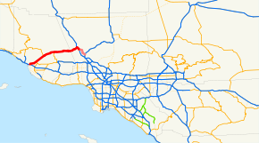
- California State Route 126
-
State Route 126
Route information Defined by S&HC § 426 Maintained by Caltrans Length: 47.167 mi[1] (75.908 km)
SR 126 is broken into pieces, and the length does not reflect the overlaps that would be required to make the route continuous.Major junctions West end: 
 SR 1 / US 101 in Ventura
 SR 150 in Santa Paula
 SR 23 in Fillmore
East end:  I-5 in Santa Clarita
Highway system State highways in California(list • pre-1964)
History • Unconstructed • Deleted • Freeway • Scenic←  SR 125
SR 127  →
→State Route 126 (SR 126) is a highway in Ventura and Los Angeles counties, California. The route runs from U.S. Route 101 in Ventura to Interstate 5 in Santa Clarita. The highway is a important connector highway in Ventura County, and serves as an alternate route into the Santa Clarita and San Fernando valleys, the High Desert of Antelope Valley, and Los Angeles.
Contents
Route description
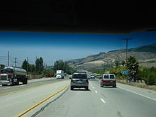 SR 126 near Fillmore
State Route 126 is the main route from Ventura County to the San Joaquin Valley via Interstate 5. The highway is officially designated as the Korean War Veterans' Memorial Highway. This route is part of the California Freeway and Expressway System[2] and is eligible for the State Scenic Highway System.[3] However, it is not a scenic highway as designated by Caltrans.[4]
State Route 126 generally follows the Santa Clara River through the valley, passing through the towns of Fillmore and Santa Paula. The freeway portion of the highway - called the Santa Paula Freeway - begins in Ventura at U.S. Route 101. It proceeds northeast through the city, interchanging with the western end of SR 118 at a grade-separated interchange. SR 126 then passes through the area of agriculture, orchards, and the Saticoy Oil Field to its northeast, continuing through Santa Paula, where it intersects SR 150, and the freeway portion terminates at Hallock Drive. SR 126 continues as a highway thereafter, known as Telegraph Road. This section extends through Fillmore as Ventura Street, where SR 126 meets SR 23. Following this, SR 126 as Telegraph Road encounters the community of Buckhorn, as well as the edge of Piru and the important historical Rancho Camulos.[5]
In Los Angleles County, SR 126 is known as Henry Mayo Drive. The highway continues east to Castaic Junction, where there is an interchange with The Old Road before a second interchange with I-5. At this interchange the SR 126 designation terminates, and the road continues into Santa Clarita as Newhall Ranch Road.[6]
History
In the late 1950s, the freeway was originally planned to continue all the way to the Antelope Valley Freeway in what is now Santa Clarita. In the face of anti-development pressure from Ventura County citizens, and suffering from severe financial problems as a result of the 1971 Sylmar earthquake and the late-1970s California tax revolt, Caltrans abandoned these plans. The only remnants of these plans are the two long ramps to and from the Antelope Valley Freeway at the Sierra Highway exit 6A in Santa Clarita.
From 1964 until 2002, a second segment of Route 126 ran from I-5 to State Route 14 through Santa Clarita via Magic Mountain Parkway and what was then called San Fernando Road (now Railroad Avenue from Magic Mountain Parkway to Main Street, all of Main Street, and Newhall Avenue from Main Street to Route 14); it has since been decommissioned.
Newhall Ranch Road in Santa Clarita, a six to eight-lane divided local road,[7] continues from the current terminus of SR 126 at Interstate 5 and roughly follows the original 1958 route to just past Bouquet Canyon Road on the north side of the Santa Clara River. Current plans are for this road to be connected[8] to Golden Valley Road via an eight-lane bridge across the Santa Clara River. This bridge would connect the road directly to SR 14 at the Golden Valley Road exit, 1 mile south of the originally planned SR 126 connector.
On March 27, 2010 the link between SR 126 and SR 14 was completed, making the connection of Newhall Ranch Road/SR 126 with Golden Valley Road/SR 14. The roadway is now a complete 50 mile highway between U.S. 101 and SR 14 with no overlap with Interstate 5 and the longer drive through Santa Clarita. State maintenance ends at Interstate 5 though with the road continuing uninterrupted with 6 lanes to SR 14.
Major intersections
- Note: Except where prefixed with a letter, postmiles were measured in 1964, based on the alignment as it existed at that time, and do not necessarily reflect current mileage. The numbers reset at county lines; the start and end postmiles in each county are given in the county column.
County Location Postmile
[1][9][10]Exit
[11]Destinations Notes Ventura
VEN 0.00-R34.64Ventura 0.00 1A US 101 north (Ventura Freeway, SR 1 north) – San FranciscoWestbound exit and eastbound entrance 0.00 1B Main Street Westbound exit and eastbound entrance 1.45 1C Victoria Avenue to US 101 south (Ventura Freeway, SR 1 south)Signed as exit 1 eastbound 2.80 3 Kimball Road R5.03 5  SR 118 (Wells Road) – Saticoy
R8.91 9 Briggs Road Santa Paula R10.38 10 Peck Road R11.37 11 Palm Avenue R12.04 12 SR 150 (10th Street) – Santa PaulaEast end of freeway Fillmore 21.14 SR 23 (A Street) – MoorparkLos Angeles
LA R0.00-R5.83Commerce Center Drive, Henry Mayo Drive to The Old Road R5.46 40A Castaic Junction Interchange; eastbound exit only Santa Clarita R5.83 40 I-5 (Golden State Freeway) – Sacramento, Los AngelesInterchange; signed as exits 40B (south) and 40C (north) R5.83 Newhall Ranch Road Continuation beyond I-5; connects to Golden Valley Road and SR 14 1.000 mi = 1.609 km; 1.000 km = 0.621 mi
Concurrency terminus • Closed/Former • Incomplete access • UnopenedReferences
- ^ a b California Department of Transportation, State Truck Route List (XLS file), accessed February 2008
- ^ CA Codes (shc:250-257)
- ^ CA Codes (shc:260-284)
- ^ "Officially Designated State Scenic Highways and Historic Parkways". California Department of Transportation. December 7, 2007. http://www.dot.ca.gov/hq/LandArch/scenic_highways/. Retrieved June 23, 2011.
- ^ Thomas Brothers (1998). Ventura County Street Atlas (Map).
- ^ Thomas Brothers (2008). Los Angeles County Street Atlas (Map).
- ^ Newhall Ranch Road widened to 8 lanes in 2008
- ^ Cross Valley Connector
- ^ California Department of Transportation, Log of Bridges on State Highways, July 2007
- ^ California Department of Transportation, All Traffic Volumes on CSHS, 2005 and 2006
- ^ California Department of Transportation, California Numbered Exit Uniform System, SR-126 Eastbound and SR-126 Westbound, accessed February 2008
External links
- California @ WestCoastRoads - State Route 126
- Caltrans: Route 126 highway conditions
- California Highways: SR 126
Freeways in Greater Los Angeles Radial Hollywood (US 101/SR 170) • Golden State (I-5) • Antelope Valley (SR 14) • Glendale (SR 2) • Pasadena/Arroyo Seco Pkwy (SR 110) • San Bernardino (I-10) • Pomona (SR 60) • Santa Ana (I-5/US 101) • Laguna (SR 133) • Corona del Mar (SR 73) • Long Beach (I-710) • Seaside (SR 47) • Terminal Island (SR 103) • Harbor (I-110/SR 110) • Marina (SR 90) • Santa Monica (I-10)Circumferential Ventura (US 101/SR 134) • Foothill (I-210) • San Gabriel River (I-605) • Orange (SR 57) • Costa Mesa (SR 55) • Artesia (SR 91) • Garden Grove (SR 22) • Century (I-105) • Gardena (SR 91) • San Diego (I-405) • Moorpark (SR 23) • Ojai (SR 33) • Ronald Reagan (SR 118) • Santa Paula (SR 126)Inland Empire Chino Valley (SR 71) • Foothill (SR 210) • Moreno Valley (SR 60) • Riverside (SR 91) • San Bernardino (I-10/I-215) • I-10 • I-15 • I-215 • SR 259 • SR 330Toll Categories:- State highways in California
- Roads in Ventura County, California
- Roads in Los Angeles County, California
- Southern California freeways


Wikimedia Foundation. 2010.