- California State Route 71
-
State Route 71
Chino Valley Freeway 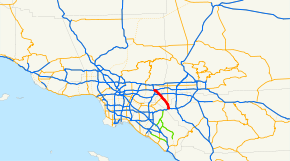
Route information Defined by S&HC § 371 Maintained by Caltrans Length: 16 mi[1] (26 km) Existed: 1934 – present Major junctions South end:  SR 91 in Corona
 SR 142 in Chino Hills
 SR 60 in Pomona
North end: 
 I-10 / SR 57 in San Dimas
Highway system State highways in California(list • pre-1964)
History • Unconstructed • Deleted • Freeway • Scenic←  SR 70
SR 70SR 72  →
→State Route 71 (SR 71) is the Chino Valley Freeway, formerly the Corona Expressway and before then the Temescal Freeway, a freeway/highway of about 15 miles (24 km) in length located entirely within Southern California, United States. Contrary to its name, this highway is only a freeway in San Bernardino and Riverside counties; in Los Angeles County it is only an expressway.
Contents
Route description
This route is part of the California Freeway and Expressway System[2] and is eligible for the State Scenic Highway System.[3] However, it is not designated as a scenic highway by Caltrans.[4] Other names of this highway include the "Police Officer Daniel T. Fraembs Memorial Highway" (Route 71 in the City of Pomona),[5] and the "Mayor James Thalman and Mayor Michael Wickman Memorial Highway" (Route 71 between Soquel Canyon Parkway & Pine Avenue in Chino Hills).[6]
Beginning at its northern terminus at the Kellogg Interchange complex in San Dimas to a short distance south of Holt Avenue in Pomona, it is a four-lane freeway. From that point and through most of Pomona, it is a four-lane expressway with at-grade intersections with other, 'regular' streets. All are signalized except for Phillips Drive. Just north of the Rio Rancho Road exit, all aspects of the highway 'upgrade' to freeway standards in its alignment, lane width, pavement, barriers, access, etc. The freeway portion of the route ends at the San Bernardino/Riverside County line, where it reverts to a divided four-lane expressway to its terminus at its junction with the Riverside Freeway (SR 91) in Corona.
The section of highway between Chino and Corona is notorious for thick winter fogs at dawn and dusk, resulting in many automobile collisions when drivers fail to slow down despite reduced visibility. Residents of Los Serranos (now Chino Hills) recall being awakened by sounds of crinkling bumpers, fenders and headlights.
As this freeway/expressway serves as an important diagonally aligned (northwest-southeast) commuter traffic corridor between the cities in the Pomona Valley (eastern Los Angeles County) and the cities of western Riverside County, it is heavily travelled and is used as an alternative to the Orange Freeway, State Route 57 (SR 57) located to the west and the Ontario Freeway, Interstate 15 (I-15) located to the east.
History
The original routing of Route 71 according to the 1934 listing was from U.S. 80, now Interstate 8, in San Diego north to U.S. Route 66, now State Route 66, near Claremont via Elsinore and Temecula.[7] The early section of Chino Valley Freeway was made in 1971 from Kellogg Interchange to Pomona Freeway. The section from SR 60 to Riverside Freeway was completed in March 1998.
Future
Mission 71 Project
In September 2008, construction began on the Mission 71 Project, in which Route 71's intersection at Mission Boulevard in Pomona will be reconstucted into a grade-separated, diamond-designed interchange. A bridge is being constructed to allow Mission to pass over Route 71, which will have entrance and exit ramps to Mission. [8]The freeway will be extended south to the current four-way intersection at Ninth Street, where it will resume expressway status to the intersection with Old Pomona Road. According to the Mission 71 Project website, the construction project is expected to take 22 months and should be completed by Fall 2011. [9]
Major intersections
- Note: Except where prefixed with a letter, postmiles were measured in 1964, based on the alignment as it existed at that time, and do not necessarily reflect current mileage. The numbers reset at county lines; the start and end postmiles in each county are given in the county column.
County Location Postmile
[10][11][12]Exit
[13]Destinations Notes Riverside
RIV R3.03-R0.00Corona R3.03 SR 91 (Riverside Freeway) – Riverside, Beach CitiesInterchange; southbound exit and northbound entrance San Bernardino
SBD R8.48-R0.00Chino Hills South end of freeway R7.98 4  SR 83 north (Euclid Avenue) / Butterfield Ranch Road
R6.52 5 Pine Avenue R4.89 7 Soquel Canyon Parkway, Central Avenue R3.35 8 SR 142 west (Chino Hills Parkway) / Ramona AvenueChino,
Chino HillsR1.82 10 Grand Avenue, Edison Avenue R0.91 11 Chino Avenue Signed as exit 11A southbound Chino Hills R0.09 12A Riverside Drive, Peyton Drive Signed as exit 11B southbound; no southbound entrance Los Angeles
LA R4.70-R0.34Pomona R4.31 12B SR 60 west (Pomona Freeway) – Los AngelesSouthbound exit is via exit 13 R4.31 12 SR 60 east (Pomona Freeway) – RiversideNorthbound exit is via exit 12A R3.61 13 Rio Rancho Road North end of freeway 1.92 Ninth Street At-grade intersection 1.62 Mission Boulevard – Pomona, Riverside, Brea, Fullerton At-grade intersection; interchange under construction; former US 60 South end of freeway 1.24 Pomona Boulevard R1.48 14A Holt Avenue, Valley Boulevard (I-10 Bus. east) to I-10 east – San BernardinoSouth end of I-10 Bus. overlap R0.34 15 I-10 west (San Bernardino Freeway) – Los AngelesNorth end of I-10 Bus. overlap; northbound exit and southbound entrance San Dimas R0.34  SR 57 north (Orange Freeway) to I-210
Northbound exit and southbound entrance; former I-210 west 1.000 mi = 1.609 km; 1.000 km = 0.621 mi
Concurrency terminus • Closed/Former • Incomplete access • UnopenedReferences
- ^ January 1, 2006 California Log of Bridges on State Highways
- ^ CA Codes (shc:250-257)
- ^ CA Codes (shc:260-284)
- ^ "Officially Designated State Scenic Highways and Historic Parkways". California Department of Transportation. December 7, 2007. http://www.dot.ca.gov/hq/LandArch/scenic_highways/. Retrieved June 22, 2011.
- ^ 2007 Named Freeways, Highways, Structures and Other Appurtenances in California. Caltrans. p. 75. http://www.dot.ca.gov/hq/tsip/hseb/products/Named_Freeways.pdf. Retrieved 2007-03-28.
- ^ Route 71 Memorial Highway One Step Closer to Completion
- ^ "Map of 1963 routes". CA Highways. http://cahighways.org/maps/1963routes.jpg. Retrieved 2008-07-27.
- ^ Mission 71 Project home page, http://www.mission71project.com, retrieved 18 June 2011.
- ^ Mission 71 Project data sheet, http://www.mission71project.com/images/pdf/Project_Data_Sheet_2.pdf, retrieved 18 June 2011.
- ^ California Department of Transportation, State Truck Route List (XLS file), accessed February 2008
- ^ California Department of Transportation, Log of Bridges on State Highways, July 2007
- ^ California Department of Transportation, All Traffic Volumes on CSHS, 2005 and 2006
- ^ California Department of Transportation, California Numbered Exit Uniform System, State Route 71 Freeway Interchanges, Retrieved on 2009-02-07.
External links
- Caltrans: Route 71 highway conditions
- California Highways: Route 71
- California @ WestCoastRoads.com - State Route 71
- Mission Boulevard interchange project
Freeways in Greater Los Angeles Radial Hollywood (US 101/SR 170) • Golden State (I-5) • Antelope Valley (SR 14) • Glendale (SR 2) • Pasadena/Arroyo Seco Pkwy (SR 110) • San Bernardino (I-10) • Pomona (SR 60) • Santa Ana (I-5/US 101) • Laguna (SR 133) • Corona del Mar (SR 73) • Long Beach (I-710) • Seaside (SR 47) • Terminal Island (SR 103) • Harbor (I-110/SR 110) • Marina (SR 90) • Santa Monica (I-10)Circumferential Inland Empire Chino Valley (SR 71) • Foothill (SR 210) • Moreno Valley (SR 60) • Riverside (SR 91) • San Bernardino (I-10/I-215) • I-10 • I-15 • I-215 • SR 259 • SR 330Toll Categories:- State highways in California
- Southern California freeways
- Roads in Los Angeles County, California
- Roads in San Bernardino County, California
- Roads in Riverside County, California


Wikimedia Foundation. 2010.