- California State Route 142
-
State Route 142
Route information Defined by S&HC § 442 Maintained by Caltrans Length: 11.467 mi[1] (18.454 km) Major junctions West end:  SR 90 in Brea
East end:  SR 71 in Chino Hills
Highway system State highways in California(list • pre-1964)
History • Unconstructed • Deleted • Freeway • Scenic←  SR 140
SR 144  →
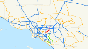
→State Route 142, (SR 142) also known as Carbon Canyon Road for most of its length, runs southwest from State Route 71 in Chino Hills, through Olinda Village to its intersection with Lambert Road and Valencia Avenue in Brea. At the intersection, the highway turns south onto Valencia Avenue and ends at State Route 90, Imperial Highway. The eastern portion of the route is known as Chino Hills Parkway.
It is signed as a scenic route from the Orange-San Bernardino County line to Peyton Drive in Chino Hills. It is a popular shortcut between the Inland Empire and the business centers of Brea and surrounding Orange County; however, the road has multiple tight curves, so travel is not recommended for long vehicles, such as big rigs.
Route description
SR 142 is part of the California Freeway and Expressway System[2] and is eligible for the State Scenic Highway System[3]. However, it has not been designated by Caltrans as a scenic highway.[4]
SR 142 begins in the city of Brea as Valencia Avenue at a junction with SR 90. The road heads northwest to an intersection with Carbon Canyon Road, which assumes the designation of SR 142 and continues east through Carbon Canyon Regional Park. SR 142 continues into the community of Olinda before crossing into the Sleepy Hollow area of the city of Chino Hills in San Bernardino County.[5]
SR 142 continues northwest through Chino Hills to an intersection, where it continues eastbound on Chino Hills Parkway. The highway ends at an interchange with SR 71 on the border of Chino Hills and Chino, near the California Institution for Men, a state prison.[6]
Major intersections
- Note: Except where prefixed with a letter, postmiles were measured in 1964, based on the alignment as it existed at that time, and do not necessarily reflect current mileage. The numbers reset at county lines; the start and end postmiles in each county are given in the county column.
County Location Postmile
[1][7][8]Destinations Notes Orange
ORA R0.75[9]-6.35Brea R0.75 Valencia Avenue Continuation beyond SR 90 R0.75 SR 90 (Imperial Highway)R1.77 Lambert Road, Valencia Avenue San Bernardino
SBD 0.00-5.78Chino Hills R3.87 Chino Hills Parkway, Rustic Drive 4.40 Peyton Drive 5.78 SR 71 (Chino Valley Freeway)Interchange 5.78 Chino Hills Parkway Continuation beyond SR 71 1.000 mi = 1.609 km; 1.000 km = 0.621 mi References
- ^ a b California Department of Transportation, State Truck Route List (XLS file), accessed February 2008
- ^ CA Codes (shc:250-257)
- ^ CA Codes (shc:260-284)
- ^ California Department of Transportation, Officially Designated Scenic Highways, accessed 2010-03-26
- ^ Thomas Brothers (2008). Orange County Road Atlas (Map).
- ^ Thomas Brothers (2008). San Bernardino County Road Atlas (Map).
- ^ California Department of Transportation, Log of Bridges on State Highways, July 2007
- ^ California Department of Transportation, All Traffic Volumes on CSHS, 2005 and 2006
- ^ It is noted that at the time of renumbering of the California State Highways, Route 142 began at the corner of Imperial Highway and Carolina Avenue (now Kraemer Boulevard), continued north on Carolina Avenue to Birch Street, then east on Birch Street to Valencia Avenue. It turned north on Valencia Avenue and followed the same route as the present. The beginning postmile is R0.75 instead of 0.00 because of the realignment and the resulting shortening of the route.
Categories:- State highways in California
- Roads in Orange County, California
- Roads in San Bernardino County, California


Wikimedia Foundation. 2010.