- California State Route 140
Infobox road
state=CA
type=SR
route=140
section=440
maint=Caltrans 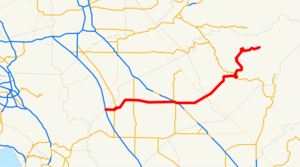
length_mi=102.10
length_round=2
direction_a=West
terminus_a=jct|state=CA|I|5 near Gustine
junction=jct|state=CA|SR|99 in Merced
jct|state=CA|SR|49 in Mariposa
direction_b=East
terminus_b=Yosemite National Park
previous_type=SR
previous_route=139
next_type=SR
next_route=142State Route 140 is an east-west, two-lane highway in central
California , 102 miles (164 km) in length. It begins in theSan Joaquin Valley at Interstate 5 near Gustine, and runs east into the Sierra Nevada Mountains, terminating inYosemite National Park .In June 2006, the road between
El Portal and Mariposa was closed due to a rock slide. The Ferguson Slide buried about 600 linear feet of SR140 between Cedar Lodge and Briceburg Visitor Center between SR49 and SR41 [cite web|url=http://www.fs.fed.us/r5/sierra/conditions/slide/ferguson-memo.pdf|title=Ferguson Rock Slide United States Department of the Interior] .Though a detour opened in August, 2006, those anticipating travel between Mariposa and El Portal (Yosemite National Park) on SR140 are still advised to contact the
National Park Service ,California Highway Patrol , Caltrans, or the Mariposa County Sheriff to find out if the road is open.This route is part of the
California Freeway and Expressway System [http://www.leginfo.ca.gov/cgi-bin/displaycode?section=shc&group=00001-01000&file=250-257 CA Codes (shc:250-257)] ] and is eligible for the State Scenic Highway System [http://www.leginfo.ca.gov/cgi-bin/displaycode?section=shc&group=00001-01000&file=260-284 CA Codes (shc:260-284)] ] .Route description
Going east from I-5, it passes Gustine. It jogs to cross the
San Joaquin River . It roughly marks the southern edge of the farmable land around Livingston. It crosses State Route 99 at Merced. Visitors who travel from the Bay Area or northern California toYosemite Valley or the southern portion of Yosemite will transfer from Highway 99 to Highway 140 at this point. (Those who visit the northern portion of Yosemite would have taken either State Route 120 east at Manteca, or State Route 132 east at Modesto.)It continues through Planada, after which the farmland gives way to grazing land. It is quite dry in the summer due to California's
Mediterranean climate , and the dry grass gives the landscape a golden color.Western meadowlark s,American kestrel s,red-tailed hawk s and even the occasionalcoyote can be seen near the road. A fewblue oak s can be seen as the highway leaves the valley and begins to climb the foothills of the Sierra Nevada Mountains. They become more and more numerous as the elevation increases. The highway passes through Catheys Valley, and the vegetation begins to diversify a little.California live oak s andPonderosa Pine s intermingle with the blue oaks as it nears Mariposa.Visitors to the
Mariposa Grove ofGiant Sequoia s in southern Yosemite would be advised to take State Route 49 south at this point. For those whose destination is in Yosemite Valley, the portion of SR 140 between Mariposa and El Portal is a California [http://www.dot.ca.gov/hq/LandArch/scenic_highways/route140.htm Scenic Highway] . A ponderosa pine forest surrounds the road as it passes through Midpines. At Briceburg, it plunges down into theMerced River valley. It runs alongside the Merced River, through El Portal, and into Yosemite Valley, where it ends.Major intersections
:"Note: Except where prefixed with a letter,
postmile s were measured in 1964, based on the alignment as it existed at that time, and do not necessarily reflect current mileage. The numbers reset at county lines; the start and end postmiles in each county are given in the county column."References
External links
* [http://www.dot.ca.gov/hq/LandArch/scenic_highways/p_rte140.htm Caltrans Route 140 Photos]
* [http://www.cahighways.org/137-144.html#140 California Highways—State Route 140]
* [http://www.fs.fed.us/r5/sierra/conditions/slide/response-plan.pdf Acrobat US Forest Service file containing a map of the slide, (June 2006).]
* [http://www.fs.fed.us/r5/sierra/conditions/ferguson-chron.shtml Current Conditions - Ferguson Rock Slide, Chronology of Events]

Wikimedia Foundation. 2010.