- Mariposa, California
-
Mariposa — census-designated place — Dusk in downtown Mariposa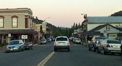 Location in Mariposa County and the state of California
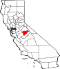
Coordinates: 37°29′06″N 119°57′59″W / 37.485°N 119.96639°WCoordinates: 37°29′06″N 119°57′59″W / 37.485°N 119.96639°W Country  United States
State  California
County Mariposa Area[1] - Total 12.880 sq mi (33.361 km2) - Land 12.850 sq mi (33.282 km2) - Water 0.030 sq mi (0.078 km2) 0.23% Elevation[2] 1,949 ft (594 m) Population (2010) - Total 2,173 - Density 168.7/sq mi (65.1/km2) Time zone Pacific (PST) (UTC-8) - Summer (DST) PDT (UTC-7) ZIP code 95338 Area code(s) 209 FIPS code 06-45932 GNIS feature ID 1659063 Mariposa (formerly Logtown)[3] is a census-designated place (CDP) in and the county seat of Mariposa County, California, United States.[4] The population was 2,173 at the 2010 census, up from 1,373 at the 2000 census. Its name is Spanish for "butterfly", after the flocks of Monarchs seen overwintering there by early explorers.
Contents
Geography
Mariposa is located at 37°29′06″N 119°57′59″W / 37.485°N 119.96639°W,[2] at 1,949 feet (594 m) in elevation. It lies in the rugged foothills of the Sierra Nevada. Mariposa Creek flows through the town.
According to the United States Census Bureau, the CDP has a total area of 12.9 square miles (33 km2), all but 0.23% of it land.
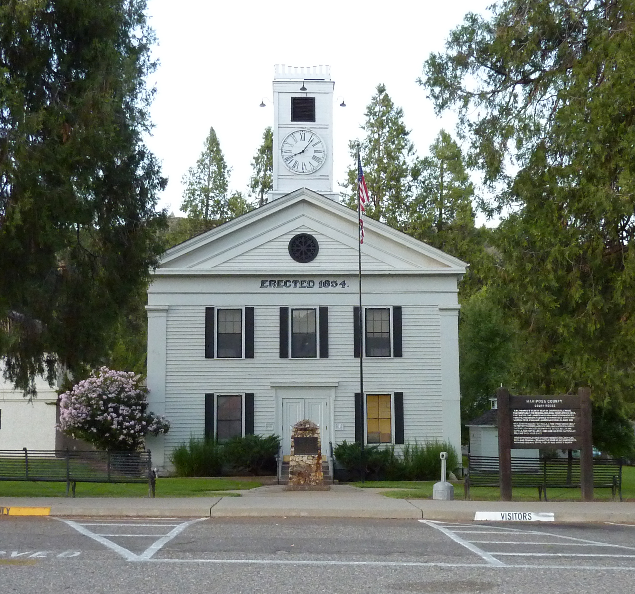
Mariposa County includes much of Yosemite National Park, and a good deal of the local economy is related to the Park and to tourism. The county courthouse, constructed in 1854, is the oldest in continuous use west of the Rockies. Tours are available.
The county lies at the southern end of the Mother Lode, and Europeans were attracted to Mariposa by gold. During the 19th century California Gold Rush, its streams were panned and deep mines worked the underground veins. At one time John C. Frémont lived here and owned claims to much of the mineral wealth of Mariposa. He later was the first United States Senator from the state, and the first Republican candidate for President.
History
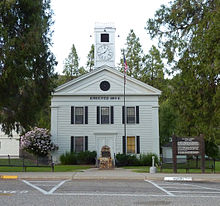 Mariposa County Courthouse
The town was founded as a mining camp.[3] The original town site was located about 0.5 miles (0.80 km) further downstream.[3] After a flood during the winter of 1849/50, the town was moved to higher ground at a site the miners called Logtown.[3] In time the old name was restored, and the Mariposa post office opened in 1851.[3] The Southern Sierra Miwuk occupied Mariposa for centuries prior to immigrants from other regions.
Demographics
2010
The 2010 United States Census[5] reported that Mariposa had a population of 2,173. The population density was 168.7 people per square mile (65.1/km²). The racial makeup of Mariposa was 1,895 (87.2%) White, 10 (0.5%) African American, 105 (4.8%) Native American, 30 (1.4%) Asian, 0 (0.0%) Pacific Islander, 59 (2.7%) from other races, and 74 (3.4%) from two or more races. Hispanic or Latino of any race were 215 persons (9.9%).
The Census reported that 2,098 people (96.5% of the population) lived in households, 12 (0.6%) lived in non-institutionalized group quarters, and 63 (2.9%) were institutionalized.
There were 1,013 households, out of which 237 (23.4%) had children under the age of 18 living in them, 365 (36.0%) were opposite-sex married couples living together, 140 (13.8%) had a female householder with no husband present, 40 (3.9%) had a male householder with no wife present. There were 60 (5.9%) unmarried opposite-sex partnerships, and 2 (0.2%) same-sex married couples or partnerships. 413 households (40.8%) were made up of individuals and 235 (23.2%) had someone living alone who was 65 years of age or older. The average household size was 2.07. There were 545 families (53.8% of all households); the average family size was 2.77.
The population was spread out with 434 people (20.0%) under the age of 18, 130 people (6.0%) aged 18 to 24, 389 people (17.9%) aged 25 to 44, 631 people (29.0%) aged 45 to 64, and 589 people (27.1%) who were 65 years of age or older. The median age was 49.3 years. For every 100 females there were 85.7 males. For every 100 females age 18 and over, there were 83.4 males.
There were 1,143 housing units at an average density of 88.7 per square mile (34.3/km²), of which 529 (52.2%) were owner-occupied, and 484 (47.8%) were occupied by renters. The homeowner vacancy rate was 3.4%; the rental vacancy rate was 5.8%. 1,082 people (49.8% of the population) lived in owner-occupied housing units and 1,016 people (46.8%) lived in rental housing units.
2000
As of the census[6] of 2000, there were 1,373 people, 676 households, and 327 families residing in the CDP. The population density was 426.4 people per square mile (164.6/km²). There were 754 housing units at an average density of 234.1 per square mile (90.4/km²). The racial makeup of the CDP was 86.8% White, 0.6% African American, 6.3% Native American, 0.9% Asian, 1.8% from other races, and 3.6% from two or more races. Hispanic or Latino of any race were 5.8% of the population.
There were 676 households out of which 21.6% had children under the age of 18 living with them, 31.4% were married couples living together, 13.6% had a female householder with no husband present, and 51.5% were non-families. 47.6% of all households were made up of individuals and 27.1% had someone living alone who was 65 years of age or older. The average household size was 1.94 and the average family size was 2.77.
In the CDP the population was spread out with 20.6% under the age of 18, 8.2% from 18 to 24, 23.2% from 25 to 44, 21.0% from 45 to 64, and 27.0% who were 65 years of age or older. The median age was 42 years. For every 100 females there were 80.4 males. For every 100 females age 18 and over, there were 78.7 males.
The median income for a household in the CDP was $18,144, and the median income for a family was $27,344. Males had a median income of $26,771 versus $26,635 for females. The per capita income for the CDP was $22,436. About 28.0% of families and 24.0% of the population were below the poverty line, including 34.5% of those under age 18 and 5.5% of those age 65 or over.
Notable residents
Some living past and present notable residents in alphabetical order include:
- Darryl Greenamyer - aviator
- Jon Leicester - baseball pitcher for the Orix Buffaloes
- Sal Maccarone - Author and Sculptor
- Sam Maccarone - Director, Screenwriter, and Actor
- Logan Mankins - Guard for New England Patriots football team
- George Radanovich - Politician and Author
Politics
In the state legislature Mariposa is located in the 14th Senate District, represented by Republican Tom Berryhill, and in the 25th Assembly District, represented by Republican Kristin Olsen. Federally, Mariposa is located in California's 19th congressional district, which is represented by Republican Jeff Denham.
References
- ^ U.S. Census
- ^ a b U.S. Geological Survey Geographic Names Information System: Mariposa, California
- ^ a b c d e Durham, David L. (1998). California's Geographic Names: A Gazetteer of Historic and Modern Names of the State. Quill Driver Books. p. 799. ISBN 9781884995149.
- ^ "Find a County". National Association of Counties. http://www.naco.org/Counties/Pages/FindACounty.aspx. Retrieved 2011-06-07.
- ^ All data are derived from the United States Census Bureau reports from the 2010 United States Census, and are accessible on-line here. The data on unmarried partnerships and same-sex married couples are from the Census report DEC_10_SF1_PCT15. All other housing and population data are from Census report DEC_10_DP_DPDP1. Both reports are viewable online or downloadable in a zip file containing a comma-delimited data file. The area data, from which densities are calculated, are available on-line here. Percentage totals may not add to 100% due to rounding. The Census Bureau defines families as a household containing one or more people related to the householder by birth, opposite-sex marriage, or adoption. People living in group quarters are tabulated by the Census Bureau as neither owners nor renters. For further details, see the text files accompanying the data files containing the Census reports mentioned above.
- ^ "American FactFinder". United States Census Bureau. http://factfinder.census.gov. Retrieved 2008-01-31.
External links
- Mariposa Storytelling Festival Annual storytelling festival in March
- Mariposa History And Genealogy
- Daily News and Photos of Mariposa
- Mariposa's Rockslide - Video
- Mariposa County High School
- Superior Court of Mariposa County
- VisitMariposa.net
Municipalities and communities of Mariposa County, California County seat: Mariposa CDPs Bear Valley | Bootjack | Buck Meadows | Catheys Valley | Coulterville | El Portal | Fish Camp | Greeley Hill | Hornitos | Lake Don Pedro | Mariposa | Midpines | Wawona | Yosemite Valley
Unincorporated
communitiesBagby | Barrett | Ben Hur | Blanchard | Briceburg | Bridgeport | Buena Vista | Clearing House | Curry Village | Darrah | Dogtown | Elliott Corner | Foresta | Granite Springs | Hayward | Hite Cove | Incline | Indian Gulch | Jerseydale | Mormon Bar | Mount Bullion | North Wawona | Ponderosa Basin | South Wawona | Yosemite Village | Yosemite West
Former
settlementsAgua Fria | Bondville | Chinquapin | Drum | Eightmile | Elevenmile | Elkhorn | Emory | Hokokwito | Kocher | Kumaini | Macheto | Minear | Mount Ophir | Newtown | Notomidula | Opie | Phillip's Flat | Quartzburg | Ridleys Ferry | Sakaya | Sloss | Wenger | Wiskala | Yosemite Mill
California county seats Consolidated city-county Municipalities Alturas | Auburn | Bakersfield | Colusa | Crescent City | El Centro | Eureka | Fairfield | Fresno | Hanford | Hollister | Jackson | Lakeport | Los Angeles | Madera | Martinez | Marysville | Merced | Modesto | Napa | Nevada City | Oakland | Oroville | Placerville | Red Bluff | Redding | Redwood City | Riverside | Sacramento | Salinas | San Bernardino | San Diego | San Jose | San Luis Obispo | San Rafael | Santa Ana | Santa Barbara | Santa Cruz | Santa Rosa | Sonora | Stockton | Susanville | Ukiah | Ventura | Visalia | Willows | Woodland | Yreka | Yuba City
CDPs Bridgeport | Downieville | Independence | Mariposa | Markleeville | Quincy | San Andreas | Weaverville
Categories:- Census-designated places in Mariposa County, California
- County seats in California


Wikimedia Foundation. 2010.