- California State Route 66
Infobox road
state=CA
type=SR
route=66
alternate_name=Foothill Boulevard, 5th Street
section=366
maint=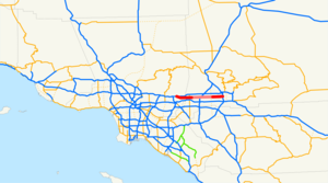
length_mi=32.321
length_ref=
length_round=3
length_notes=Portions of SR 66 are not included in the length.Portions of this route have been relinquished to or are otherwise maintained by local or other governments, and are not included in the length.]
established=1974 (from US 66) [ [http://www.us-highways.com/us2.htm#US_66 U.S. Highways: East-West Routes] ]
direction_a=West
terminus_a=jct|state=CA|I|210 in La Verne
junction=jct|state=CA|I|15 in Rancho Cucamonga
direction_b=East
terminus_b=jct|state=CA|I|215 in San Bernardino
previous_type=SR
previous_route=65
next_type=SR
next_route=67
commons=categoryState Route 66 is a
state highway in theU.S. state ofCalifornia , running along a section of old U.S. Route 66 from La Verne east to San Bernardino, passing through Claremont, Upland, Rancho Cucamonga, Fontana and Rialto along Foothill Boulevard. In San Bernardino, it is the part of Fifth Street west of H Street (at the Interstate 215 interchange).This route is part of the
California Freeway and Expressway System [http://www.leginfo.ca.gov/cgi-bin/displaycode?section=shc&group=00001-01000&file=250-257 CA Codes (shc:250-257)] ] .Major intersections
:"Note: Except where prefixed with a letter,
postmile s were measured in 1964, based on the alignment as it existed at that time, and do not necessarily reflect current mileage. The numbers reset at county lines; the start and end postmiles in each county are given in the county column."References
External links
* [http://www.westcoastroads.com/california/ca-066.html California @ WestCoastRoads.com - State Route 66]
* [http://www.dot.ca.gov/hq/roadinfo/sr66 Caltrans: Route 66 highway conditions]
* [http://www.cahighways.org/065-072.html#066 California Highways: SR 66]

Wikimedia Foundation. 2010.