- California State Route 55
-
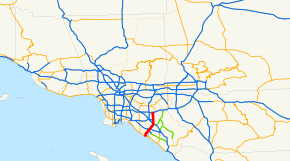
State Route 55
Route information Defined by S&HC § 355 Maintained by Caltrans Length: 18 mi[citation needed] (29 km) Existed: 1964 – present Major junctions South end:  SR 1 in Newport Beach
 I-405 in Costa Mesa
 I-5 in Tustin
North end:  SR 91 in Anaheim
Highway system State highways in California(list • pre-1964)
History • Unconstructed • Deleted • Freeway • Scenic←  SR 54
SR 54SR 56  →
→State Route 55 (SR 55) is an 18-mile (30-km) long north–south highway in the U.S. state of California. The portion of the route built to freeway standards is known as the Costa Mesa Freeway (formerly the Newport Freeway). SR 55 runs between the Pacific Coast Highway (State Route 1 in Newport Beach to the south and the Riverside Freeway (State Route 91) in Anaheim to the north.
Contents
Route description
This route is part of the California Freeway and Expressway System.[1]
Starting at Finley Avenue on Newport Boulevard in Newport Beach, 0.3-mile (0.48 km) south of SR 1, Route 55/Newport Boulevard is a 4-lane expressway for approximately three-quarters of a mile to its intersection with 17th Street in Costa Mesa. It then follows a traditional street routing through a retail and commercial section of Costa Mesa until its intersection with 19th Street. Following the 19th Street intersection, Route 55 becomes an eight-lane below-grade freeway that bisects the northbound and southbound lanes of Newport Boulevard until the Mesa Drive undercrossing. North of Fair Drive, Route 55 is an at-grade or above-grade freeway, with the exception of a one mile (1.6 km) stretch between the 1st Street/4th Street exit and the 17th Street exit in Santa Ana which is below-grade.
The segment on Newport Boulevard includes a limited-access interchange at SR 1. The southbound side of the Costa Mesa Freeway does not have a direct link to northbound Interstate 5, the Santa Ana Freeway. Route 55 is known to be crowded due to it being the primary free link from job centers in Irvine, Santa Ana and Costa Mesa to SR 91, which leads to commuter communities of the Inland Empire and other places northeast of Orange County.
SR 55 was the first freeway in Orange County to receive carpool lanes,[2] opened in 1985. The stretch of the 55 between Fair Dr. and 19th Street in Costa Mesa was opened in 1990; plans to extend the 55 freeway south from 19th Street to State Route 1 were never realized, but in April 2007, the Orange County Transportation Authority approved funds to study the feasibility of extending the Costa Mesa Freeway south to 17th Street via tunnels or flyover ramps.[2] Route 55 from Route 91 to Costa Mesa is known as the Costa Mesa Freeway, as named by Assembly Concurrent Resolution 177, Chapter 86 in 1976.[3]
History
Route 55 was originally built in 1931 and was originally numbered as Route 43. It was built from the southern terminus of SR 1 (the Pacific Coast Highway, or "PCH") and continued northbound on the same route it follows today, through the cities of Newport Beach, Tustin, Costa Mesa, Orange and Anaheim, and then went eastward through Riverside on what is known today as Route 91 to link with Interstate 215. In 1959 the freeway was renumbered as Route 55, and its route was shortened from Route 1 to the also-renumbered Route 91.[4]
Today, Route 55 is a heavily-travelled corridor linking southern Orange County with Route 91, the main corridor between the Inland Empire and the Los Angeles Metropolitan Area, as well as Interstate 5, the main north–south corridor for California. A HOV lane has been built along the entire route, with its own off- and on-ramps. However, congestion is still very prevalent throughout the day, as is the norm with many Orange County freeways; Route 55 experiences a peak daily traffic volume of 262,000 vehicles and 17,292 trucks.[5]
The entire freeway section of Route 55, approximately 16 miles (26 km), is called the Costa Mesa Freeway. It was formerly called the Newport Freeway, with the name being changed by the legislature in 1976. Caltrans did not begin changing signs to reflect the name change until the early 1990s. In 2010, the stretch between Chapman and Katella avenues in the City of Orange was renamed the Paul Johnson Freeway for longtime local radio television traffic reporter Paul Johnson, who died the same year.[6]
Exit list
- Note: Except where prefixed with a letter, postmiles were measured in 1964, based on the alignment as it existed at that time, and do not necessarily reflect current mileage.
The entire route is in Orange County.
Location Postmile
[7][8][9]Exit
[10]Destinations Notes Newport Beach 0.00 Newport Boulevard Continuation beyond SR 1 0.27 1 SR 1 (Pacific Coast Highway) – Laguna Beach, San Diego, Long BeachInterchange; former US 101 Alt. Costa Mesa 1.51 East 17th Street 1.82 Harbor Boulevard 2.02 19th Street South end of freeway 2 Newport Boulevard Northbound exit and southbound entrance R2.77 3 Victoria Street, 22nd Street R3.78 4 Del Mar Avenue, Fair Drive R4.73 5A  SR 73 north (Corona del Mar Freeway) to I-405 north (San Diego Freeway) – Long Beach
Northbound exit and southbound entrance R4.73 5A SR 73 south (Corona del Mar Freeway) – San Diego via toll roadR5.34 5B Baker Street R5.99 6A I-405 north (San Diego Freeway) – Long BeachSouthbound exit and northbound entrance R5.99 6B I-405 south (San Diego Freeway) – San Diego, John Wayne AirportSigned as exit 6 northbound Santa Ana R6.99 7 MacArthur Boulevard, Main Street R7.85 8 Dyer Road Signed as exits 8A (east) and 8B (west) southbound R9.44 9 Edinger Avenue Tustin R9.96 10A McFadden Avenue – Tustin Signed as exit 10 southbound 10.45 10B I-5 north (Santa Ana Freeway) – Santa AnaNorthbound exit and southbound entrance; former US 101 north 10.45 11A I-5 south (Santa Ana Freeway) – San DiegoFormer US 101 south 10.98 11B 4th Street, Irvine Boulevard 11.79 12 17th Street – Tustin, Santa Ana Signed as exits 12A (east) and 12B (west) southbound 12.97 13  SR 22 west (Garden Grove Freeway) – Long Beach
13.70 14 Chapman Avenue (CR S25 east) – Orange Signed as exits 14A (east) and 14B (west) northbound Orange 15.24 15 Katella Avenue (CR S18 south) – Villa Park 16.98 17 Lincoln Avenue, Nohl Ranch Road Lincoln Avenue was former US 91 south / former SR 18 south Anaheim R17.88 18A SR 91 west (Riverside Freeway) – Los AngelesNorthbound exit and southbound entrance; former SR 14 north R17.88 18B SR 91 east (Riverside Freeway) – RiversideNorthbound exit and southbound entrance; former US 91 north / former SR 18 north R17.88 91 Express Toll Lanes Northbound left exit and southbound entrance 1.000 mi = 1.609 km; 1.000 km = 0.621 mi
Concurrency terminus • Closed/Former • Incomplete access • UnopenedReferences
- ^ CA Codes (shc:250-257)
- ^ a b OC Set To Study New End to 55 Freeway. Los Angeles Times. pp. 2. http://www.thetransitcoalition.us/newspdf/lat20070422a.pdf. Retrieved 2007-04-22.
- ^ 2007 Named Freeways, Highways, Structures and Other Appurtenances in California. Caltrans. pp. 59. http://www.dot.ca.gov/hq/tsip/hseb/products/Named_Freeways.pdf. Retrieved 2007-03-27.
- ^ SR-55 Background and History
- ^ http://www.dot.ca.gov/hq/traffops/saferesr/trafdata/truck2005final.pdf
- ^ http://www.mediabistro.com/tvspy/longtime-knbc-traffic-reporter-gets-his-own-freeway_b6968
- ^ California Department of Transportation, State Truck Route List (XLS file), accessed February 2008
- ^ California Department of Transportation, Log of Bridges on State Highways, July 2007
- ^ California Department of Transportation, All Traffic Volumes on CSHS, 2005 and 2006
- ^ California Department of Transportation, California Numbered Exit Uniform System, State Route 55 Freeway Interchanges, Retrieved on 2009-02-05.
Freeways in Greater Los Angeles Radial Hollywood (US 101/SR 170) • Golden State (I-5) • Antelope Valley (SR 14) • Glendale (SR 2) • Pasadena/Arroyo Seco Pkwy (SR 110) • San Bernardino (I-10) • Pomona (SR 60) • Santa Ana (I-5/US 101) • Laguna (SR 133) • Corona del Mar (SR 73) • Long Beach (I-710) • Seaside (SR 47) • Terminal Island (SR 103) • Harbor (I-110/SR 110) • Marina (SR 90) • Santa Monica (I-10)Circumferential Ventura (US 101/SR 134) • Foothill (I-210) • San Gabriel River (I-605) • Orange (SR 57) • Costa Mesa (SR 55) • Artesia (SR 91) • Garden Grove (SR 22) • Century (I-105) • Gardena (SR 91) • San Diego (I-405) • Moorpark (SR 23) • Ojai (SR 33) • Ronald Reagan (SR 118) • Santa Paula (SR 126)Inland Empire Chino Valley (SR 71) • Foothill (SR 210) • Moreno Valley (SR 60) • Riverside (SR 91) • San Bernardino (I-10/I-215) • I-10 • I-15 • I-215 • SR 259 • SR 330Toll Categories:- State highways in California
- Southern California freeways
- Roads in Orange County, California
- Newport Beach, California
- Transportation in Anaheim, California


Wikimedia Foundation. 2010.