- California State Route 56
Infobox road
state=CA
type=SR
route=56
section=356
maint=Caltrans 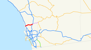
length_mi=16
length_round=2
length_ref= [ [http://www.dot.ca.gov/hq/structur/strmaint/brlog2.htm January 1, 2006 California Log of Bridges on State Highways] ]
direction_a=West
terminus_a=jct|state=CA|I|5 in Carmel Valley
direction_b=East
terminus_b=jct|state=CA|I|15 in Rancho Peñasquitos
previous_type=SR
previous_route=55
next_type=SR
next_route=57State Route 56 runs from Interstate 5 in the Carmel Valley neighborhood of
San Diego to Interstate 15. Route 56 was originally planned in 1964 to connect to the north end of State Route 125 and continue east to State Route 67, but Poway worked to make sure that would not be possible. Now SR 56 ends into Ted Williams Parkway on the East end. Route 56 is also called the Ted Williams Freeway (thus, both are named afterbaseball playerTed Williams , who was born in San Diego).The stub segment on the west end from I-5 to Carmel Valley Rd and the stub segment on the east end from Black Mountain Rd to I-15 were built first, and traffic first flowed on these stub ends of the freeway in 1994. A convert|5|mi|km|sing=on gap in the freeway remained for nearly a decade, until 2003. At that time, traffic opened on the east end from Black Mountain Rd to Camino Del Sur, but it took until
July 19 2004 to finally complete the middle segment. However, all the work still has yet to be completed. The ramps to I-15 are still under construction; and ramps from Route 56 west to I-5 north, as well as those from I-5 south to Route 56 east, will not be built until at least 2010. Until then, traffic is routed along local streets through Carmel Valley.The cost of completing just the middle convert|5.5|mi|km|sing=on segment was reported at $220 million, in 2004. Within weeks of completing the middle segment of the freeway SANDAG started a study about the I-5 connector ramps, which hopefully will be completed by 2012.

Wikimedia Foundation. 2010.