- Golden State Freeway
Infobox road
state=CA
type=I
route=5
highway_name=Golden State Freeway
maint=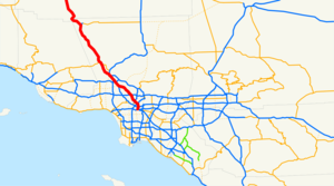
direction_a=South
terminus_a=Jct|state=CA|I|10|SR|60|US|101 in Los Angeles
junction=Jct|state=CA|SR|134 near Glendale
Jct|state=CA|SR|14 near Santa Clarita
direction_b=North
terminus_b=Jct|state=CA|SR|99 in Lebec
system=Southern California freeways The Golden State Freeway is a north-southfreeway running through Kern County andLos Angeles County, California . Originally built as U.S. Route 99, it was re-signed as Interstate 5 in 1964.Route description
I-5 and State Route 99 converge near the southernmost point of the
San Joaquin Valley , approximately 30 miles (50 km) south of Bakersfield. At this point, the Golden State Freeway begins. It travels southward through the valley until sharply rising through Grapevine Canyon pastFort Tejon ,Lebec , and theFrazier Park exit to crossTejon Pass through theTehachapi Mountains .Path 26 power lines, a southern extension ofPath 15 , follow the freeway across the pass, pastGorman , theAntelope Valley (Mojave Desert ) exit, and on to Pyramid Lake. At one point along the treacherous route in Violin Canyon near Castaic, the separated northbound and southbound lanes actually invert, with the southbound lanes being to the east of the northbound ones. The freeway continues into theSanta Clarita Valley , and then crossesNewhall Pass through theSanta Susana Mountains to enter theSan Fernando Valley , and in turn, Los Angeles. Several major freeways split from the Golden State Freeway within a few miles of this point: the Foothill Freeway (I-210) near Sylmar, the San Diego Freeway (I-405) in Mission Hills, and the Hollywood Freeway (US 101 & SR-170) in Sun Valley. Traveling through the cities of Burbank and Glendale, it closely follows theLos Angeles River as it skirtsGriffith Park and other sections of theHollywood Hills (the easternmost extensions of theSanta Monica Mountains ). The Golden State ends at theEast Los Angeles Interchange in Boyle Heights; I-5 continues thereafter as theSanta Ana Freeway .While the former surface street portions of State Route 99 are often named the Golden State Highway or Golden State Avenue, Highway 99 itself is not called the Golden State Freeway.
Legal definition
The Golden State Freeway is Route 5 from the 5/10/60/101 Junction to Route 14, as named by the Metropolitan Transportation Engineering Board on
February 28 1958 . [cite book | url=http://www.dot.ca.gov/hq/tsip/hseb/products/Named_Freeways.pdf | title=2007 Named Freeways, Highways, Structures and Other Appurtenances in California | publisher=Caltrans | pages=60 | accessdate=2007-03-28] Note that the segment from State Route 14 to Highway 99 is still legally unofficial.Earthquakes and the Golden State Freeway
On
February 9 ,1971 , theSylmar earthquake destroyed a portion of the Golden State Freeway, including its interchange (then under construction) with theAntelope Valley Freeway , between the Santa Clarita and San Fernando valleys. It was soon rebuilt with greater seismic reinforcement, but nevertheless sustained heavy damage in theJanuary 17 ,1994 Northridge earthquake (and again had to be rebuilt).The risk of earthquake damage to the freeway remains high, as the Grapevine route crosses the notorious
San Andreas Fault . The risk along this route is such that the proposedhigh-speed rail corridor between Los Angeles and San Francisco, originally planned to be built within the Golden State Freeway's alignment, will instead veer east into theAntelope Valley , going through the cities of Palmdale and Lancaster before traversing the more seismically stableTehachapi Pass on its way to Bakersfield. Despite adding over 50 miles (80 km) of line to the railroad and 20 minutes to its travel time, the route change will save billions of dollars in construction costs, as Tehachapi Pass presents relatively few engineering concerns.Exit list
:"Note: Except where prefixed with a letter,
postmile s were measured in 1964, based on the alignment as it existed at that time, and do not necessarily reflect current mileage. The numbers reset at county lines; the start and end postmiles in each county are given in the county column."References

Wikimedia Foundation. 2010.