- Lebec, California
Infobox Settlement
official_name = Lebec, California
settlement_type = CDP
imagesize =
image_caption =
image_
imagesize =
image_caption =
image_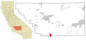
mapsize = 250x200px
map_caption = Location in Kern County and the state ofCalifornia
mapsize1 =
map_caption1 =
subdivision_type = Country
subdivision_type1 = State
subdivision_type2 = County
subdivision_name =United States
subdivision_name1 =California
subdivision_name2 = Kern
government_type =
leader_title = N/A
leader_name =
leader_title1 = Senate
leader_name1 =Roy Ashburn (R)
leader_title2 = Assembly
leader_name2 =Jean Fuller (R)
leader_title3 = U. S. Congress
leader_name3 = Kevin McCarthy (R)
established_date =
area_magnitude =
area_total_km2 = 40.5
area_total_sq_mi = 15.6
area_land_km2 = 40.5
area_land_sq_mi = 15.6
area_water_km2 = 0
area_water_sq_mi = 0
elevation_ft = 3481
elevation_m = 1061
population_as_of = 2000
population_footnotes =
population_total = 1285
population_metro =
population_density_km2 = 31.7
population_density_sq_mi = 82.4
timezone = PST
utc_offset = -8
latd = 34 |latm = 50 |lats = 32 |latNS = N
longd = 118 |longm = 53 |longs = 3 |longEW = W
timezone_DST = PDT
utc_offset_DST = -7
postal_code_type =ZIP code
postal_code = 93243
area_code = 661
blank_name = FIPS code
blank_info = 06-40956
blank1_name = GNIS feature ID
blank1_info = 0272011
footnotes =
website =Lebec is an
unincorporated area in Kern County,California . It is one of theMountain Communities of the Tejon Pass . The population was 1,224 at the 2000 census.Geography
According to the
United States Census Bureau , LeBec has an area of 15.6square mile s (40.5km² ).Population
"Source for this information was [http://www.factfinder.census.gov/servlet/SAFFFacts?_event=Search&geo_id=&_geoContext=&_street=&_county=Lebec&_cityTown=Lebec&_state=04000US06&_zip=&_lang=en&_sse=on&pctxt=fph&pgsl=010&show_2003_tab=&redirect=Y|U.S. Census Bureau, American FactFinder.] "
In the 2000
census GR|2, almost all the 1,224 residents (95 percent) were white. There were only three blacks. There were 256 Hispanics or Latinos of any race (20 percent of all residents). Other residents included 16 American Indians or Alaska natives and four Asians.The median age for Lebec residents was 36 years — almost the same as the 35 years for the nation as a whole.
Lebec also had slightly more veterans than its share — 169, or 19 percent, compared to 13 percent around the country.
Fifty-nine percent of Lebec adults were working. They had to travel some 27 minutes to get to their jobs, about the same as most Americans.
Lebec households had a lower median income than the nation as a whole — $46,857, compared to $50,046.
There were just 100 people (or 8 percent) below the
poverty level in Lebec in 2000 — significantly less than the nation as a whole, which was 12 percent in 2000.Of the 516 housing units, 319 were occupied by owners and 127 by renters — about the same 7-3 ratio as the rest of the country. Sixty housing units (12 percent) were vacant.
References
External links
http://www.MountainEnterprise.com (local newspaper)
Wikimedia Foundation. 2010.