- California State Route 178
Infobox road
state=CA
type=SR
route=178
section=478
maint=Caltrans 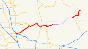
length_mi=166.81
length_round=0
length_ref=cite web|url=http://www.dot.ca.gov/hq/structur/strmaint/brlog2.htm|title=California Log of Bridges on State Highways|format=PDF|publisher=California Department of Transportation|date=January 1 ,2006 |accessdate=2007-06-18]
direction_a=West
terminus_a=jct|state=CA|SR|58|SR|99 in Bakersfield
junction=jct|state=CA|US|395 near Ridgecrest
Trona Rd. near TronaDeath Valley
jct|state=CA|SR|127 at Shoshone
direction_b=East
terminus_b=jct|state=NV|SR|372 towardsPahrump, NV
previous_type=SR
previous_route=177
next_type=SR
next_route=180State Route 178 (SR 178) is a route that exists in two constructed segments. The gap in between segments is connected by various local roads and State Route 190 through
Death Valley National Park .This route is part of the
California Freeway and Expressway System [http://www.leginfo.ca.gov/cgi-bin/displaycode?section=shc&group=00001-01000&file=250-257 CA Codes (shc:250-257)] ] and is eligible for the State Scenic Highway System [http://www.leginfo.ca.gov/cgi-bin/displaycode?section=shc&group=00001-01000&file=260-284 CA Codes (shc:260-284)] ] .Route description
Western segment
The first segment starts at State Route 99 just west of Downtown Bakersfield. The road continues as 24th street, but then splits at B St. utilizing 24th street as its westbound usage, and 23rd St. as its eastbound through the eastern part of Downtown Bakersfield. 178 then becomes a freeway as it departs Bakersfield. The freeway ends about convert|5|mi|km east of Downtown and becomes a two-lane conventional highway that ascends the lower Sierra Nevada Mountains on its way to
Lake Isabella . Just south of Lake Isabella, the road briefly again becomes a divided limited access freeway, but later converts back to a two lane road at the at-grade junction with Lake Isabella Blvd. The road winds a little bit until it ascends toWalker Pass , an elevation of over convert|5000|ft|m. The highway then descends from the mountains to its junction with State Route 14. It then proceeds eastward across US 395 into the town of Ridgecrest, CA. The constructed highway ends at the turnoff for the Trona Pinnacles National Natural Landmark.Eastern segment
The second segment resumes four miles (6 km) west of Salisberry Pass in the southeasterly part of
Death Valley National Park in Inyo County at what had been the former boundary of Death Valley National Monument until 1994. It then meets up with State Route 127. 178 then branches northward from 127 to the California-Nevada State Line. In Nevada, the roadway continues as State Route 372 ending at State Route 160 near the center of Pahrump in Nye County. Plans to connect the two constructed segments in California are unlikely due to the would-be link's passage throughDeath Valley National Park .The segment of State Route 178 from State Route 127 to the California-Nevada State Line as well as all of Nevada State Route 372 are both known as the Charles Brown Highway. Charles Brown, a former California State Legislator, was a major proponent for the incorporation of the segment of State Route 178 between State Route 14 and the California-Nevada state line into the California Highway System.
Major intersections and exit list
:"Note: Except where prefixed with a letter,
postmile s were measured in 1964, based on the alignment as it existed at that time, and do not necessarily reflect current mileage. The numbers reset at county lines; the start and end postmiles in each county are given in the county column."References
Images along SR178
External links
* [http://www.dot.ca.gov/hq/roadinfo/sr178 Caltrans: Route 178 highway conditions]
* [http://www.westcoastroads.com/california/ca-178.html West Coast Roads: State Route 178]
* [http://www.cahighways.org/177-184.html#178 California Highways: State Route 178]

Wikimedia Foundation. 2010.