- Santa Monica Mountains
Geobox|Range
name=Santa Monica Mountains

image_caption=Malibu Canyon in the Santa Monica Mountains
country=United States
state = California
region_type = Counties
region= Los Angeles
region1= Ventura
region2=
parent=Transverse Ranges
border=Santa Susana Mountains |border1=Simi Hills |border2=Verdugo Mountains
highest=Sandstone Peak
highest_elevation_imperial=3111
highest_lat_d=
highest_long_d=
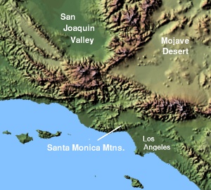 The Santa Monica Mountains are a low transverse range in southern
 California in theUnited States .Geography
They run for approximately 40 mi (64 km) east-west from the
Hollywood Hills in Los Angeles toPoint Mugu in Ventura County. The mountains form a barrier between theSan Fernando Valley and theLos Angeles Basin , separating "the Valley" on the north and west-central Los Angeles on the south. Santa Monica Mountains areparallel toSanta Susana Mountains , which is located directly north of the mountains across the San Fernando Valley. Beginning at the eastern end of the San Fernando Valley, the mountains are bordered to the north by the Los Angeles River. The river flows south after Elysian Park, defining the easernmost exent of the mountains. Mount shington, on the other side of the river, has almost identical native flora and climate, however.Geology
Geologists consider the northern Channel Islands to be a westward extension of the Santa Monicas into the
Pacific Ocean . The range was created by repeated episodes of uplifting and submergence by theRaymond Fault that created complex layers ofsedimentary rock. Volcanic instrusions have been exposed, including the poorly named "Sandstone Peak", the highest in the range at 948 meters (3,111 ft).Malibu Creek , which eroded its own channel while the mountains slowly tilted up, bisects the range.Climate
The Santa Monica Mountains have
dry , warm to humid summers and wet,mild tocool winters. In the summer, the climate is very dry, which makes the range prone towildfires .Snow is very occasional (rare) in the Santa Monica Mountains, as they are not as high as the nearbySan Gabriel Mountains .On
17 January 2007 , an unusually cold storm brought snow in the Santa Monica Mountains. Malibu picked up 3 in (8 cm) ofsnow - the first measurable snow in 5 decades (50 years). Snow was also reported inBoney Peak , in the winter of 2005, and in March 2006, snow also fell on the summit of the mountain.Wildlife
The Santa Monica Mountains are in the
California chaparral and woodlands ecoregion and are covered by hundreds of local plant species, some of which are very rare, and others of which have become popular ornamentals. The range is host to an immense variety of wildlife, frommountain lion s to the endangered steelhead.Additional information
The mountains have more than 1,000 sites of archeological significance, particularly in regard to the
Tongva and Chumash people. Today, the Santa Monica Mountains face pressure from local populations, who see the range as a recreational retreat, a desirable residential area, and as an increasingly rare wild place in urbanLos Angeles .In local speak, "going over the hill" refers to crossing the range.
Cahuenga Pass , present-day site of U.S. Route 101, is the easiest pass through the range connecting theLos Angeles Basin to theSan Fernando Valley . In the 1800s, two battles were fought there, and theTreaty of Cahuenga was signed nearby. In the heyday of Hollywood movie studios clustered on both sides of it.Sepulveda Pass is the main north-south pass to the west, connecting the Westside to Sherman Oaks via theSan Diego Freeway (I-405). Further west areTopanga Canyon Boulevard (SR 27),Malibu Canyon Road , andKanan Dume Road .Mulholland Drive runs much of the length of the Santa Monica Mountains, from Cahuenga Pass to Woodland Hills while theMulholland Highway runs from Woodland Hills toSequit Point . The eastern end of the range, located in the City of Los Angeles, is more intensively developed than the western end of the range. The city of Malibu runs between the coast and the leading mountain ridge, from Topanga Canyon in the east toLeo Carrillo State Park in the west. The termMalibu Ozarks is sometimes used derogatorily (or ironically) for the unincorporated part of Malibu beyond the leading mountain ridge and lacking an ocean view; the term is often used synonymously with "818 Malibu" (referring to the less desirable San Fernando Valley telephone area code prefix).Much of the mountains are located within the
Santa Monica Mountains National Recreation Area . Preservation of lands within the region are managed in part by theSanta Monica Mountains Conservancy . Over twenty individual state and municipal parks are in the Santa Monica Mountains, including:Topanga State Park ,Leo Carrillo State Park ,Malibu Creek State Park ,Point Mugu State Park ,Will Rogers State Historic Park ,Point Dume State Beach ,Griffith Park ,Marvin Braude Mulholland Gateway Park ,Charmlee Wilderness Park ,Runyon Canyon Park , and theParamount Ranch .Communities along the north slope of the mountains include (from east to west):
*the Los Angeles communities of:
**Studio City
**Sherman Oaks
**Encino
**Tarzana
**Woodland Hills
*Calabasas
*Agoura Hills
*Westlake Village
*Thousand Oaks
*Newbury Park
*Simi ValleyCommunities along the south slope of the mountains include (from east to west):
*the Los Angeles communities of:
**Los Feliz
**Hollywood Hills
**Bel-Air
**Brentwood
**Pacific Palisades
*Beverly Hills
*the unincorporated community of Topanga
*MalibuNamed peaks
Los Angeles River
The southwestern headwaters of the
Los Angeles River are in the Santa Monica Mountains. The Los Angeles River also forms the northern boundary of the mountains from the easternmost part of the San Fernando Valley to Elysian Park, where the river turns south, thereby defining the easternmost part of the mountain range.Griffith Park
Griffith Park and finallyElysian Park are the eastern end of the Santa Monical Mountains. Griffith Park is separated from the rest of the Santa monica Mountains to the west by theCahuenga Pass , over which the101 Freeway passes from theSan Fernando Valley intoHollywood . Elysian Park is the easternmost part of the mountains and is bordered by theLos Angeles River to the east.Fauna (Animals) of the Santa Monica Mountains
Native and Non NativeReptiles:(Western Fence Lizard, Bluebelly)Mammals: "Neotoma spp. " (pack rat): "Homo Sapiens" (Humans)Birds
Fungi of the Santa Monica Mountains
Flora (Plants) of the Santa Monica Mountains
The
Santa Monica Mountains are dominated by two ecosystems,coastal sage scrub along the coast, thenchapparal as the Mountains rise from the coast.Native and Non Native
Monocotyledones
*Agavaceae :Yucca whipplei
*Amaryllidaceae :"Allium peninsulare ":"Bloomeria crocea ":"Dichelostemma pulchellum "
*Iridaceae : (Blue Eyed Grass )
*Liliaceae :"Calochortus splendens " (“beautiful” “grass”), (“splendid”):"Calochortus venustus ":"Calochortus spp.":"Chlorogalum pomeridianum " (“green” “juice”) (“afternoon”) (Soap Plant):"Fritillaria biflora "
*Orchidaceae :(Stream Orchid )
*Poaceae alt.Gramineae : "Elymus condensatus "Dicotyledons
*Aizoaceae :(Ice Plant ):"Carpobrotus edulis ":"Mesembryanthemum crystallinum "
*Anacardiaceae (Sumac , includescashew s):"Malosma laurina " (Laurel Sumac ):"Rhus integrifolia " (Lemonadeberry ):"Rhus ovata " (Sugar Bush ):"Rhus trilobata " (Squaw Bush ) (commonly confused withPoison Oak , but no petiole on middle of three leaves): "Toxicodendron diversilobum " (Poison Oak ) (MAY CAUSE EXTREME SKIN PROBLEM IF TOUCHED OR GONE NEAR, petiole on middle of three leaf clusters)
*Apiaceae (Umbel flowers,Carrots ): "Conium maculatum " (Poison Hemlock , looks like fennel, but POISONOUS): "Foeniculum vulgare " (SweetFennel )
*Asteraceae :(Yarrow ): "Artemisia californica " (Coastal Sage Brush , smells good when rubbed, edible,tarragon is a variety): "Baccharis glutinosa " (Mule fat , sticky leaves): "Baccharus pilularis " (Coyote Brush ): "Centaurea melitensis " (YellowStar Thistle , nasty invader): "Cirsium occidentale " : "Encelia californica ": "Eriophyllum confertiflorum ": "Gnaphalium californicum ": "Malacothrix saxatilis " (Cliff Aster ): "Silybum marianum :Misc (sunfowers)
*Boraginaceae
*Brassicaceae : "Brassica nigra ” (BlackMustard ) (“nigra” = “black”): "Stanleya pinnata "
*Cactaceae : "Opuntia littoralis "
*Capparaceae : "Isomeris arborea ": "Sambucus mexicana " (MexicanElderberry )
*Caryophyllaceae : "Silene laciniata "
*Chenopodiaceae : "Salsola iberica " (Tumbleweed )
*Cistaceae : "Cistus villosus ": "Helianthemum scoparium " (“Scoparium” = “broom”): "Calystegia macrostegia " (Morning Glory ): "Cuscuta californica " (Dodder , Orangebeard, Witches Hair)
*Crassulaceae : "Dudeya lanceolata ": "Dudleya pulverulenta ” (“pulverulent” = “pulverized to powder”. Refers to chalky wax on leaves.)
*Cucurbitaceae : "Cucurbita foetissima ": "Marah macrocarpus "
*Ericaceae (Heath family ): "Arctostaphylos glandulosa "
*Euphorbiaceae : "Euphorbia albomarginata ": "Ricinus communis "
*Fabaceae (Leguminosae ,Pea family): "Lotus scoparius " {Broom ): "Lupinus " spp.: "Lupinus hirsutissimus ": "Medicago sativa ": "Pickeringia montana ": "Spartium junceum "
*Gentianaceae : "Centaurium venustum "
*Geraniaceae: "Erodium cicutarium "
*Hydrophyllaceae : "Eriodictyon crassifolium " (Yerba Santa ): "Phacelia cicutaria " (Caterpillar Phacelia) ): "Phacelia grandiflora ": "Phacelia parryi "
*Lamiaceae (Mint ): "Marrubium vulgare " (Horehound ): "Salvia apiana " (White Sage ): "Salvia comumbariae " (Chia ): "Salvia leucophylla " (Purple Sage ): "Salvia mellifera " (Black sage )
*Malvaceae : "Malacothamnus fasciculatus " : "Malva parviflora " (Cheeseweed )
*Nyctaginaceae : "Abronia umbellata " (Verbena ): "Mirabilis californica " (Wishbone Plant )
*Onagraceae : "Clarkia deflexa ": "Clarkia unguiculata ": "Zauschneria californica "
*Oxalidaceae : "Oxalis pes-caprae " (lemon flavored)
*Paeoniaceae : "Paeonia californica "
*Papaveraceae : "Dendromecon rigida ": "Dicentra ochroleuca ": "Eschscholzia californica ": "Papaver californicum ": "Romneya coulteri "
*Polemonacea : "Leptodactylon californicum ": "Linanthus dianthiflorus "
*Polygonaceae : "Eriogonum crocatum ": "Eriogonum cinereum " : "Eriogonum elongatum ": "Eriogonum fasciculatum ": "Rumex crispus "
*Portulaceae : "Claytonia perfoliata ":Primulaceae : "Anagalis arvensis ": "Dodecatheon clevelandii "
*Ranunculaceae : "Clematis ligusticifolia ": "Delphinium cardinale :: "Delphinium parryi ": "Ranunculus californicus "
*Rhamnaceae : "Ceanothus crassifolius ": "Ceanothus cuneatus ": "Ceanothus leucodermis ": "Ceanothus megacarpus ": "Ceanothus oliganthus ": "Ceanothus spinosus ": "Rhamnus californica "
*Rosaceae : "Adenostoma fasciculatum ": "Cercocarpus betuloides ": "Heteromeles arbutifolia ": "Prunus ilicifolia ": "Rosa californica ": "Rubus ursinus "
*Saxifragaceae : "Ribes aureum ": "Ribes malvaceum ": "Ribes speciosum "
*Scrophulariaceae (Figwort family): "Anirrhinum coulterianum ":"Antirrhinim kelloggii ": "Castilleja affins ": "Casrilleja foliolosa ": "Castilleja marinii ": "Mimulus brevipes ": "Mimulus aurantiacus ": "Mimulus cardinalis ": "Mimulus guttatus ": "Mimulus longiflorus ": "Mimulus pilosus ": "Orthocarpus purpurascens ": "Pedicularis densiflora ": "Penstemon centranthifolius ": " [Penstemon hetero [hyllus] ": "Penstemon spectabilis "
*Solanaceae : "Datura meteloides ": "Nicotiana glauca ": "Nicotiana bigelovii ": "Nicotiana glauca ": "Solanum douglasii ": "Solanum xantii ee also
Nearby mountain ranges
*
Simi Hills
*Santa Susana Mountains
*Verdugo Mountains
*San Gabriel Mountains External links
* [http://outdoorla.org/trails/ Outdoor LA Hiking Trails] - Hiking trails in the area with maps and directions to the trailheads.
* [http://www.nps.gov/samo/ Santa Monica Mountains National Recreation Area]
* [http://smmc.ca.gov/ Santa Monica Mountains Conservancy]
* [http://www.timetotrack.com/jay/ Wildflowers of the Santa Monica Mountains]
* [http://www.cccarto.com/wmaps/SMMNRA/ SMMNRA Interactive Locator Map]
Wikimedia Foundation. 2010.