- Interstate 238
Infobox road
state=CA
type=I
route=238
section=538
maint=Caltrans 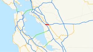
length_mi=2.16
length_round=2
length_ref= [http://www.dot.ca.gov/hq/structur/strmaint/brlog2.htm January 1, 2006 California Log of Bridges on State Highways] ]
established=May1983 by FHWA [http://cahighways.org/itypes.html California Highways: Interstate Highway Types and the History of California's Interstates] ]
direction_a=South
terminus_a=jct|state=CA|I|580|SR|238 in Castro Valley
direction_b=North
terminus_b=jct|state=CA|I|880 in San Leandro
previous_type=SR
previous_route=237
next_type=SR
next_route=238Interstate 238 (I-238) is a short auxiliary route of the
Interstate Highway System in theSan Francisco Bay Area ,California ,United States . Part of State Route 238 until 1983, and still considered the same route (part of Route 238) by theCalifornia Department of Transportation (Caltrans), it connects Interstate 580 in Castro Valley (where SR 238 continues south) with Interstate 880 in San Leandro. Despite running in an east-west direction, it is signed north-south, as the rest of Route 238 is more north-south than east-west.The number does not follow established rules for numbering Interstates, as there is no Interstate 38. Of the nine possible numbers ending in 80 (as it connects two auxiliary routes of Interstate 80), two - 180 and 480 - were in use by State Routes (the latter an Interstate until 1968), and the seven others were used by other Interstates. (I-880 was designated at the same time as I-238; it too could only be an auxiliary route of I-80.)
This route is part of the
California Freeway and Expressway System [http://www.leginfo.ca.gov/cgi-bin/displaycode?section=shc&group=00001-01000&file=250-257 CA Codes (shc:250-257)] ] .Route description
Although the convert|2.16|mi|km|sing=on I-238 goes in an east-west direction from Castro Valley to San Leandro, Caltrans officially signs it as a north-south freeway since the rest of State Route 238 is more north-south. The south (or east) terminus of I-238 is at its interchange with Interstate 580 and SR 238 in Castro Valley. From there, it enters into the southern portion of the
census-designated place of Ashland, running parallel to its border with Cherryland. Then after entering San Leandro, I-238 terminates at Interstate 880.History
The section of road that is now I-238 had no signed number before the 1964 renumbering; it was pre-1964 Legislative Route 228 (along with an unbuilt extension west to unbuilt State Route 61, which is still included in the Route 238 definition).
The segment from what is now I-580 to I-880 was built as a
freeway in 1956. The rest of SR 238 south to Interstate 680 in Fremont was also planned to be upgraded to a freeway (parallel to present I-880), but after it was unsuccessfully submitted to the Interstate Highway System in October1968 , and after several lawsuits, it never got off the ground. [ [http://cahighways.org/233-240.html#238 California Highways (www.cahighways.org): Routes 233 through 240 ] ]When present Interstate 880 was added to the Interstate Highway System as a renumbering of part of State Route 17, the short piece of SR 238 connecting I-880 to I-580 was also added; both were non-chargeable routes (not eligible for Interstate Completion funds). Both numbers - I-238 and I-880 - were approved by the
American Association of State Highway and Transportation Officials (AASHTO) onJuly 7 ,1983 . The interchanges with I-580 and I-880 were rebuilt from 1988 to 1994, in part to add missing ramps between I-238 and I-880 towards the south. Prior to the completion of the ramps, access was provided by Hesperian Boulevard.As the
American Association of State Highway and Transportation Officials said onJuly 7 ,1983 when approving the designation, cquote|This is to inform you that your application for the elimination of Route 180 and extension of Route 580, and the establishment of Route 880 and Route 238 have been approved.However, since the I-238 designation does not fit the overall national numbering sequence and was necessitated only because all [Three-digit Interstate|three [-digit] combinations] of I-80 have been used, the Committee has a further option to offer for your consideration. If the I-580 designation were continued from Castro Valley to San Lorenzo and then used in place of the proposed I-880 designation northerly to Oakland and over existing I-180 between Albany and San Rafael, then existing I-580 between Castro Valley and Oakland could be designated I-180. The Committee does recognize this option would involve considerable resigning, however.
Caltrans responded on July 27, 1983:With the deletion of State Route 480 in 1991, the "480" designation is once again available.
Future
The entire length of I-238 is being reconstructed, including a reconfigured interchange with I-880, and an added travel lane in each direction. The existing pavement is being removed to allow for the roadbed to be rebuilt, then new pavement will be laid. Additionally, almost all of the bridges and overpasses are being replaced with new ones meeting current
earthquake resistance standards.Fact|date=March 2007Exit list
:"Note: Except where prefixed with a letter,
postmile s were measured in 1964, based on the alignment as it existed at that time, and do not necessarily reflect current mileage."The entire route is in Alameda County.References
External links
* [http://www.gbcnet.com/roads/I-238/ Indigestion 238] : A history of the route and a full explanation of its numbering
* [http://www.kurumi.com/roads/3di/ix38.html Kurumi - I-238 California]

Wikimedia Foundation. 2010.