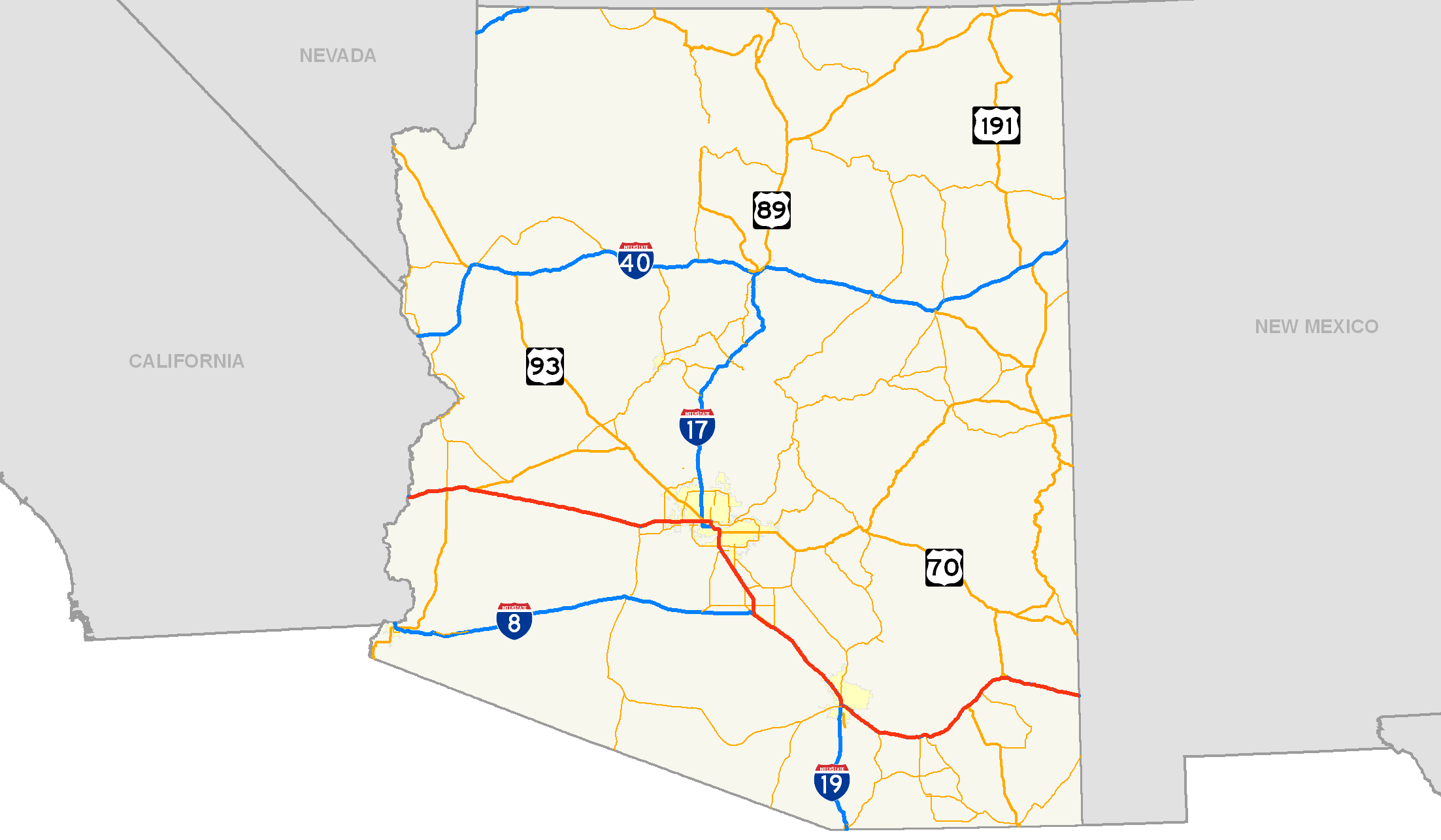
- Interstate 10 in Arizona
-
This article is about the section of Interstate 10 in Arizona. For the entire length of the highway, see Interstate 10.
Interstate 10
Papago Freeway, Maricopa Freeway, Pearl Harbor Memorial Highway 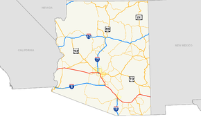
Route information Maintained by Arizona DOT Length: 391.99 mi[1] (630.85 km) Major junctions West end: 
 I-10 / US 95 at California state line
 US 95 in Quartzsite
 US 60 near Brenda
 I-17 / US 60 in Phoenix
US 60 in Tempe
 I-8 in Casa Grande
 I-19 in Tucson
 US 191 near Wilcox
East end:  I-10 at New Mexico state line
Highway system Main route of the Interstate Highway System
Main • Auxiliary • BusinessState routes in Arizona
Unconstructed • Former← I-8I-15  →
→In the U.S. state of Arizona, Interstate 10, the major east–west Interstate Highway in the southern United States, runs east from California, enters Arizona and continues through Phoenix and Tucson and exits at the border with New Mexico.
Contents
Route description
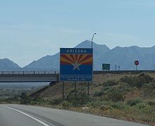
The western terminus is located at the California border at the Colorado River in La Paz County where I-10 continues westward into California towards Los Angeles. Here, the same physical road is signed as both Interstate 10 and U.S. Route 95. The highway runs east by northeast past Ehrenberg and Quartzsite and then turns to an east by southeast orientation just before the junction for U.S. Route 60. I-10 is 391.2 miles long in Arizona.
Papago Freeway
It continues this path entering Maricopa County and the Phoenix Metro area. The route turns east by northeast again at the junction for SR 85 northwest of downtown Buckeye, and turns due east at 203rd Ave/Tuthill Rd. The landscape by this point is largely urban and the freeway continues eastward through the communities of Goodyear, Avondale and Tolleson, meeting with area freeways such as Loop 303 and the western side of Loop 101 along the way.
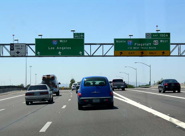
Traversing through Phoenix, the highway meets with Interstate 17 for the first time just northwest of downtown at The Stack. Near 3rd Avenue, the highway enters a half-mile tunnel (800 m) that runs under a park and the central branch of the City of Phoenix Library. Emerging past 3rd Street, the highway continues due eastward for another 2 miles (3.2 km) before coming to another interchange for Route 51 and Loop 202, called the Mini Stack. At this interchange, Interstate 10 turns southward for about 3 miles (4.8 km), passing near Sky Harbor Airport and reaching the second junction with Interstate 17. Here, I-17 and I-10 merge as I-10 skews eastward again. After this junction, the highway is signed as US 60 as well.
- as of 10-22-11, I-10 now has mile markers posted every 2/10 mile from 112.2 to 110.8 with the interstate shield and direction of travel posted on the westbound lanes. And from 110.8 to 112.2 eastbound but without the I-10 shield and direction of travel.
- EB I-10, speed limit now drops to 65 at Verrado Way (exit 120) and from mile 124-126 the speed limit is 55 mph.
WB I-10, 65 mph speed limit now extends to just west of exit 120 with a two mile stretch posted at 55 mph from mile 126-124 around the loop 303 exit.
Maricopa Freeway
Continuing southeast over the Salt River and eastward, I-10 enters Tempe and meets with SR 143. Then, at the Broadway Curve, the freeway turns southward again, with US 60 splitting off to become its own freeway. I-10 continues southward running along the city borders of Phoenix on the west, and Tempe, Guadalupe, Tempe again, and finally Chandler on the east. Immediately north of the Gila River Indian Community, I-10 has its second intersection with Loop 202. Past Loop 202, the highway turns to a more south by southeast direction going through the Gila River Indian Community and entering Pinal County.
Pearl Harbor Memorial Highway
Interstate 10 in Arizona outside the Phoenix Metropolitan Area is referred as the Pearl Harbor Memorial Highway. In Phoenix, I-10 is referred as the Papago, Inner-Loop and Maricopa Freeway.
Annual Average Daily Traffic
Annual Average Daily Traffic (AADT) counts for Interstate 10 at the state lines and the cities it passes through in Arizona are listed below.
Exit
[2]Location 2006
AADT[2]2007
AADT[2]2008
AADT[2]0 CA State Line 29,500 26,000 25,500 17 Quartzsite 23,500 20,000 17,500 120 Buckeye 54,500 62,000 59,000 135 Tolleson 138,000 185,000 177,000 146 Phoenix 291,000 288,000 257,000 155 Tempe 206,000 200,000 221,000 160 Chandler 116,000 116,000 113,000 198 Casa Grande 43,000 44,500 37,500 257A Tucson 169,000 176,000 178,000 303 Benson 17,500 17,000 16,500 340 Willcox 14,000 14,500 14,500 390 NM State Line 12,000 12,500 12,500 History
 Entering from California
Interstate 10 in Arizona was laid out by the Arizona Highway Department in 1956-58 roughly paralleling several historic routes across the state. Particularly east of Eloy, it follows the Butterfield Stage and Pony Express routes, and loops south to avoid the north–south Basin and Range mountains prevalent in the state. In fact, the route from its junction with Interstate 8 east to New Mexico is almost exactly the same route used by the old horse-drawn stagecoaches, which had to go from waterhole to waterhole and avoid the hostile Apache Indians. This is why I-10 is more of a north–south route between Phoenix and Tucson than east–west. The Southern Pacific Sunset Route line had to take the route of least hills, and in the 1920s highways were laid down next to the trains across southern Arizona.
When the project was being designed in the 1950s, the Arizona Highway Department fought for a nearly straight-shot west from Phoenix for the new freeway, instead of angling northwest out of Phoenix along U.S. 60-70-89, through Wickenburg. Wickenburgers battled to bring the freeway through their city but lost that battle. The detour up through Wickenburg was logical decades earlier, when nearly all U.S. highways through Arizona were laid out along railroad tracks, and U.S. 60-70 was routed mostly parallel to the Santa Fe rail tracks east of Wickenburg, and the Arizona and California Railway west to Vicksburg. The two old federal routes then struck west across the desert and state line, picking up the Southern Pacific mainline at Indio, California, and I-10 overlies the old roads most of that distance.
Moving east from the California line at Ehrenburg, I-10 follows the old route of U.S. 60-70 for the first 31 miles (50 km) east from Blythe, California. In 1960, this western-most stretch of I-10 was built from near the Colorado River east to the future spot where the "Brenda Cutoff" section of I-10 would connect a decade later. Until the early '70s, this was the last freeway stretch until Phoenix. The "Brenda Cutoff" was named for a gas station on the old road just east of the fork where U.S. 60 now terminates at I-10. Now an obscure name, "Brenda Cutoff" was the working title that the Arizona Highway Department called the stretch of freeway from U.S. 60 to near Buckeye. The Brenda Cutoff paralleled old sand roads used in the 1920s for Phoenix-L.A. traffic, but mostly abandoned after U.S. 60-70 was built to the north, through Wickenburg.
The Brenda Cutoff's opening in the early 1970s was eagerly awaited and was a big deal in newspapers in Phoenix and Los Angeles. It saved motorists from having to drive through Glendale, Sun City, Wickenburg and Salome, 20 miles (32 km) out of the way, and it eliminated about 80 miles (130 km) of two-lane highway. But the freeway was opened only as far east as Tonopah, and heavy traffic was routed down narrow county roads through the desert and fields between Tonopah and Buckeye. In addition, there was only one very-small gas station on the very-long route between Buckeye and Quartzsite, on the old county road at the tiny crossroads of Palo Verde. Signs warning "NO SERVICES NEXT 106 MILES" were posted at either end of the Brenda Cutoff those first few years.
The freeway was extended past Tonopah as far east as Phoenix's western fringes in about 1974. I-10's freeway section ended in Goodyear until the controversial Papago Freeway was finished across the western Valley of the Sun in 1990. During the "west valley gap" years, westbound I-10 traffic was routed off the Maricopa Freeway at 19th Avenue in Phoenix, and stayed on the access road as it curved past the Durango Curve. Los Angeles-bound traffic then turned left on Buckeye Road and followed the "TO 10" signs down Buckeye Road (first marked U.S. Route 80 until 1977, then Arizona 85) for nearly 15 years.
The interstate's route through Phoenix was hotly contested in the 1960s, 1970s and early '80s. A plan proposed by the Arizona Department of Transportation involved monstrous block-sized 270-degree "helicoil" interchanges at Third Avenue and Third Street that would connect motorists to freeway lanes 100 feet (30 m) in the air, but voters killed it in 1973 as a result of opposition from the Arizona Republic newspaper and a growing nationwide anti-freeway sentiment. Voters on election day were treated to a photo depiction on the front page of the newspaper that in later years was shown to have drastically-overstated the freeway's height, but there is no question the proposed viaducts and helicoils would have been a visual gash across central Phoenix.
Beginning in 1961, a stub of what is now the route of Interstate 10 was built northward from the Maricopa Freeway (then Interstate 10) along 20th Street, ending 1/2 mile north at Buckeye Road. The I-10/I-410 interchange was the first multi-level interchange in Arizona and lasted until the Papago Loop was built as a real freeway in the 1980s. It was first posted as Interstate 410, then as Interstate 510. This putative freeway was two lanes in each direction and would have been hopelessly inadequate as a leg of the "Inner Loop" as it was intended. The spirit of Interstate 510 lives on as "Arizona 51," the section of freeway paralleling 20th Street north of the "Mini Stack" interchange with Interstate 10 and Loop 202.
After 1973, Arizona engineers favored a more-modest plan to link I-10 with Interstate 17 at the "Durango Curve" near 19th Avenue at Buckeye Road, and avoid the "Moreland Corridor" Papago Freeway alignment by adopting a route south of Buckeye road. Ten years later, ADOT unveiled the current below grade plans on Moreland Street, three blocks south of McDowell Road. Despite some local opposition, I-10 was finally completed in central Phoenix on the Papago Freeway alignment, 3/4 of a mile north of Van Buren Street, on August 10, 1990.[3] The state is now considering a reliever west valley freeway, parallel to I-10 on the old Durango Street corridor, and was originally designated as Route 801, which has since been changed to Arizona State Route 30.
The original 1962 alignment of I-10 through Phoenix was on the Black Canyon and Maricopa freeways, now signed as I-17 and U.S. 60, starting at about Grand Avenue. From 1962-74, Interstate 10 in Phoenix ended at 40th Street, and truck traffic through Phoenix and Mesa was directed to use Arizona Route T-69 via 40th Street south and Baseline Road east to connect to state Routes 87 and 93, the shortcuts to Tucson. The 10 signs were moved from the Maricopa Freeway to the Papago Freeway Inner Loop alignment when it opened in 1990 - the last gap of I-10 to be completed between Santa Monica and Jacksonville. This was the only time in Arizona where the posted freeway was moved from one road to another: the state never posted Interstate signs on older state or U.S. highways... ADOT instead made frequent use of interstate shields with the word "TO" above and arrows below the shield.
For several years in the early '70s an orphan section of I-10 was opened between Baseline Road and Williams Field Road (now Chandler Blvd.) but was not marked as any highway, nor was it connected to the rest of the Interstate Highway System. ADOT, it seems, did not want to divert trucks down from T-69 in Guadalupe down into the cotton fields west of Chandler. This section got its interstate signs when the freeway south to Casa Grande was completed in about 1970, and the "Broadway Curve" was connected a year or so later—for almost two years, I-10 traffic used Baseline Road and 40th Street through the Japanese flower gardens until the last link between Tucson and Phoenix opened in about 1972.
From 1958-1972, the interstate was unmarked south from Tempe and Mesa, and traffic used either State Route 87 (Arizona) through Coolidge or State Route 93 (Arizona) through Casa Grande, or U.S. 80/89 through Mesa and Florence. Interstate 10 signs reappeared at the town of Picacho, the 1962-1970 western terminus of the freeway from Tucson.
The road from Casa Grande to Tucson was originally Arizona routes 84 and 93, and when it was rebuilt as a freeway in 1961-62 it was cosigned as Interstate 10 and routes 84 and 93 through 1966, when 84 was truncated at Picacho. This section of interstate was completed in 1961, and forced the demolition of the town center at Marana, which has never really recovered. The freeway through Tucson, which was rebuilt and widened in stages from 1989 to 2009, with frontage roads added, was originally signed as State Route 84 from Miracle Mile to Sixth Avenue.
The original highway from Casa Grande to Tucson entered the Old Pueblo via Miracle Mile, a road modeled after German Autobahns but without overpasses or an exclusive right of way. Traffic circles at either end of Miracle Mile were the best Tucson could come up with in 1937. The section of Miracle Mile West stretching between Miracle Mile and the Southern Pacific overpass was signed as Business Loop 10, State Route 84A and State Route 93 in the 1960s. It is now marked as the southern leg on State Route 77, the new designation for US 80-89 north out of Tucson. The Business Loop designation was dropped in 1998.
The present-day Interstate 10 alignment along the Santa Cruz River was laid out after a city bond issue passed in 1948 to build a riverbank-side boulevard with room for a four-lane freeway in the median to follow. The first section of bypass artery, from Congress Street north to Miracle Mile West, was opened in 1954 but had no overpasses or interchanges at Grant Road, Speedway Boulevard or St. Mary's Road. The freeway was finally built after the state took over the bypass and promised it interstate status in 1958, and parts of it obliterated the original road. It was first signed State Route 84.
The old cloverleaf at Sixth Avenue was the first built in Arizona, opening in the early 1950s as a southern Tucson gateway junction to the roads linking Tucson, Benson, Nogales and the hoped-for Tucson bypass along the Santa Cruz River. It was converted to a diamond interchange by 1964 and the old "quick dip" underpass was removed and replaced by an interstate-standard overpass in the late 1980s.
Although the controversial Interstate 10 route across Phoenix was the last gap of Interstate 10 to be completed, two pieces of the interstate were subsequently left sitting on divided remnants of old U.S. 80 and were neither built to interstate nor modern safety sections. One was the old Sixth Avenue interchange, and a small section of freeway east to the overpass over the old Southern Pacific (now UP) spur to Nogales and Guaymas. That section was replaced about 1990.
The last section of old U.S. 80 that carries the Interstate 10 traffic is an underpass beneath the Union Pacific mainline east of Tucson, where the freeway median shrinks to a guardrail at Marsh Station Road and the Pantano train overpass is too low. This underpass is now in the process of being replaced, with completion by 2011.
East of Tucson, Interstate 10 parallels and in some cases overlies old U.S. 80 to Benson, and was originally co-signed as U.S. 80 and State Route 86. From Benson, the Interstate follows the Southern Pacific mainline east through Willcox and Bowie to New Mexico, rather than bend south to the Mexican border along old U.S. 80 (signed as State Route 80 after 1989), through Douglas. The road from Benson east through Willcox was designated State Route 86 in about 1935, that route number was subsequently shifted west and exists now between Why and Tucson. The bypass around Benson was opened about 1979, and other than the Phoenix gap was the last section of Interstate 10 to be opened.
The Arizona Department of Transportation in 2008 conducted a feasibility study of building new bypass freeways around Phoenix and Tucson and "straighten" Interstate 10 across the state. One route would have gone roughly from Buckeye east to Florence, then east through mountainous terrain to the Sulphur Springs Valley and connect with the existing Interstate 10 near Bowie. But this new roadway would traverse some environmentally fragile areas and was opposed as a gateway to urban sprawl. Another studied alignment would bypass Tucson to the south, forming a looping bypass freeway from Marana through the Avra Valley to Green Valley to Benson, an alternative that is still being studied.
Broadway Curve
As of a 2006 estimate, the Broadway Curve portion of I-10 in Tempe carries an average of 294,000 vehicles per day.[4] This number is predicted to increase by over 150,000 to approximately 450,000 by the year 2025.[5] This section of the Maricopa Freeway (Interstate 10) is currently twelve lanes wide, and is the widest section of freeway in the valley. A study is underway to determine whether widening the Broadway Curve to double its current width to twenty-four lanes is feasible. The study should be complete in 2010, when a decision will be made.[6]
Exit list
County Location Mile[1] # Destinations Notes La Paz 0.72 1 Ehrenburg, Parker 5.87 5 Tom Wells Road 11.99 11 Dome Rock Road Quartzsite 17.54 17  US 95 south to SR 95 north – Parker, Yuma, Quartzsite
East end of US 95 overlap 19.94 19 Quartzsite 26.68 26 Gold Nugget Road 31.18 31 US 60 east – Wickenburg, Prescott45.38 45 Vicksburg Road 53.98 53 Hovatter Road 69.69 69 Avenue 75E Maricopa 81.24 81 Salome Road 94.18 94 411th Avenue – Tonopah 98.32 98 Wintersburg Road 103.47 103 339th Avenue Buckeye 109.70 109 Sun Valley Parkway, Palo Verde Road 112.77 112  SR 85 south to I-8 – Gila Bend, Yuma
114.88 114 Miller Road – Buckeye 117.01 117 Watson Road 120.24 120 Verrado Way 121.72 121 Jackrabbit Trail Goodyear 124.73 124  Loop 303 / Cotton Lane
126.71 126 Pebblecreek Parkway, Estrella Parkway 127.71 127 Bullard Avenue 128.72 128 Litchfield Road – Goodyear 129.71 129 Dysart Road Avondale 131.71 131 Avondale Boulevard 132.69 132 107th Avenue Westbound exit is via exit 133A 133.69 133A 99th Avenue Tolleson 133.98 133B  Loop 101 north (Agua Fria Freeway)
134.69 134 91st Avenue – Tolleson 135.68 135 83rd Avenue Phoenix 136.18 136A 79th Avenue HOV only; westbound exit and eastbound entrance 136.70 136B 75th Avenue Signed as exit 136 eastbound 137.69 137 67th Avenue 138.67 138 59th Avenue 139.66 139 51st Avenue 140.66 140 43rd Avenue 141.67 141 35th Avenue 142.67 142 27th Avenue Eastbound exit and westbound entrance 143.18 143 I-17 (Black Canyon Freeway) / US 60 – FlagstaffSigned as exits 143A (north) and 143B (south) 143.89 143C 19th Avenue, Grand Avenue westbound exit and eastbound entrance 144.68 144A 7th Avenue Signed as exit 144 westbound 144.70 144B 5th Avenue, 3rd Avenue HOV only; eastbound exit and westbound entrance 145.46 145A 7th Street Signed as exit 145 eastbound 145.70 145B 3rd Street HOV only; westbound exit and eastbound entrance 146.71 146 16th Street Eastbound exit and westbound entrance 146.96 147A  Loop 202 east (Red Mountain Freeway) – Tempe
147.27 147B  SR 51 north (Piestewa Freeway) – Paradise Valley
147.27 147C Loop 202 east (Red Mountain Freeway)HOV only; eastbound exit and westbound entrance 147.27 147C SR 51 north (Piestewa Freeway)HOV only; westbound exit and eastbound entrance 148.18 148 Washington Street, Jefferson Street 148.94 149 Sky Harbor International Airport Eastbound exit and westbound entrance 149.34 149 Buckeye Road Westbound exit and eastbound entrance 149.57 150A I-17 north (Maricopa Freeway) / US 60 west – FlagstaffWest end of US 60 overlap; signed as exit 150 eastbound 150.94 150B 24th Street Westbound exit and eastbound entrance 151.50 151 University Drive, 32nd Street 152.39 152 40th Street 153.38-153.75 153  SR 143 north (Hohokam Expressway, 48th Street) / Broadway Road, 52nd Street – Sky Harbor Airport
Signed as exits 153A (SR 143) and 153B (Broadway Road, 52nd Street) westbound Tempe 155.25 154 US 60 east (Superstition Freeway) – Mesa, GlobeEast end of US 60 overlap; also includes HOV eastbound exit and westbound entrance 155.94 155 Baseline Road Guadalupe 157.98 157 Elliot Road – Guadalupe Tempe 158.98 158 Warner Road Chandler 159.98 159 Ray Road 160.98 160 Chandler Boulevard 161.50 161 Loop 202 east (Santan Freeway) / Pecos Road162.82 162 Wild Horse Pass Boulevard, Sundust Road 164.80 164  SR 347 (Queen Creek Road)
167.78 167 Riggs Road – Sun Lakes Pinal 176.11 175  SR 587 (Casa Blanca Road)
185.56 185 
 SR 187 / SR 387 – Sacaton, Florence
190.95 190 McCartney Road Casa Grande 195.19 194  SR 287 (Florence Boulevard)
198.40 198 Jimmie Kerr Boulevard – Casa Grande 199.36 199 I-8 west – San DiegoEloy 200.40 200 Sunland Gin Blvd – Arizona City 204.13 203 Toltec Road – Eloy 209.09 208 Sunshine Boulevard – Eloy 211.27 211A Picacho Eastbound exit only 211.27 211B  SR 87 north – Coolidge
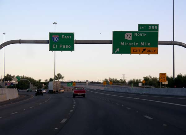
Signed as exit 211 westbound 212.49 212 Picacho Westbound exit only 220.13 219 Picacho Peak Road – Picacho Peak State Park 226.74 226 Red Rock 232.30 232 Pinal Air Park Road Pima Marana 236.71 236 Marana 240.74 240 Tangerine Road 243.24 242 Avra Valley Road 244.81 244 Twin Peaks Road Tucson 247.02 246 Cortaro Road 249.01 248 Ina Road 250.35 250 Orange Grove Road 251.47 251 Sunset Road 252.71 252 El Camino del Cerro, Ruthrauff Road 254.59 254 Prince Road 255.57 255  SR 77 north (Miracle Mile)
256.46 256 Grant Road 257.61 257 Speedway Boulevard, (St. Marys Road, 6th Street)(eastbound) – University of Arizona 258.65 258 Congress Street, Broadway Boulevard, (St. Marys Road, 6th Street) (westbound) 259.63 259 22nd Street, 29th Street, Starr Pass Boulevard, Silverlake Road 260.39 260 I-19 south – Nogales261.28 261 6th Avenue, 4th Avenue 262.02 262 Benson Highway, Park Avenue 262.86 263 Kino Parkway, Ajo Way – Tucson International Airport Signed as exits 263A (south) and 263B (north) eastbound 264.73 264 Palo Verde Road, Irvington Road Signed as exits 264A (south) and 264B (north) eastbound 265.32 265 Alvernon Way 267.40 267 Valencia Road – Tucson International Airport 268.39 268 Craycroft Road 269.64 269 Wilmot Road 270.87 270 Kolb Road 273.43 273 Rita Road 275.77 275 Houghton Road 279.68 279 Wentworth Road, Vail Road 281.96 281  SR 83 south – Sonoita, Patagonia
289.71 289 Marsh Station Road 292.77 292 Empirita Road Cochise 297.45 297 Mescal Road, J-6 Ranch Road 299.63 299 Skyline Road Benson 302.67 302  SR 90 south – Fort Huachuca, Sierra Vista
304.16 303 
 I-10 Bus. east to SR 80 – Benson, Douglas
No westbound exit 305.20 304 Ocotillo Street – Benson 307.43 306 I-10 Bus. west (Pomerene Road) to SR 80 – Benson313.56 312 Sibyl Road 319.76 318 Dragoon Road 323.39 323 Johnson Road 332.41 331 US 191 south – Sunsites, DouglasWest end of US 191 overlap 337.69 336 I-10 Bus. east (Taylor Road) – WillcoxWillcox 341.33 340  SR 186 (Rex Allen Drive, Fort Grant Road)
345.28 344 I-10 Bus. west – Willcox353.19 352 US 191 north – SaffordEast end of US 191 overlap 356.77 355 To US 191 north – Safford363.66 362 I-10 Bus. east – Bowie367.60 366 I-10 Bus. west – Bowie379.75 378 I-10 Bus. east – San Simon383.14 382 I-10 Bus. west (Portal Road) – San Simon391.57 390 Cavot Road References
- ^ a b Arizona Department of Transportation. "ADOT Highway Log". http://tpd.az.gov/mpd/data/reports/PDF/2005SHSLog.pdf. Retrieved July 16, 2007.
- ^ a b c d "Arizona AADT Reports". ADOT. http://www.azdot.gov/mpd/data/Reports/Docs/SHStrafficLog2006-2008ver2-Rounded.xls. Retrieved 2010-10-05.
- ^ "The Way It Was in 1956". USDOT. http://www.tfhrc.gov/pubrds/06jan/01.htm. Retrieved 2008-04-13.
- ^ "State proposes an additional 10 lanes for highway". East Valley Tribune. Archived from the original on 2008-05-02. http://web.archive.org/web/20080502015603/http://www.eastvalleytribune.com/story/84139. Retrieved 2008-03-18.
- ^ "202 foes love new Broadway Curve". Arizona Republic. http://www.azcentral.com/community/ahwatukee/articles/0216ar-broadway0216Z14.html. Retrieved 2008-03-18.
- ^ "Extension may help uncork Broadway Curve". Arizona Republic. http://www.azcentral.com/community/tempe/articles/0221ev-broadwaycurve0222.html. Retrieved 2008-03-18.
External links
 Interstate 10
Previous state:
CaliforniaArizona Next state:
New MexicoRoads and freeways in metropolitan Phoenix Radial Papago/Maricopa (I-10) • Black Canyon (I-17) • Piestewa (AZ 51) • Superstition (US 60) • Williams Gateway (AZ 24) • I-10 Reliever (AZ 30) • Sky Harbor (Former AZ 153)Circumferential Interchanges and other Interstate Highways in Arizona Current Cancelled Categories:- Freeways in the Phoenix metropolitan area
- Interstate Highways in Arizona
- Interstate 10
- Juan Bautista de Anza National Historic Trail
- San Pedro Valley
- Transportation in La Paz County, Arizona
- Transportation in Maricopa County, Arizona
- Transportation in Pinal County, Arizona
- Transportation in Pima County, Arizona
- Transportation in Cochise County, Arizona


Wikimedia Foundation. 2010.