- Maricopa County, Arizona
-
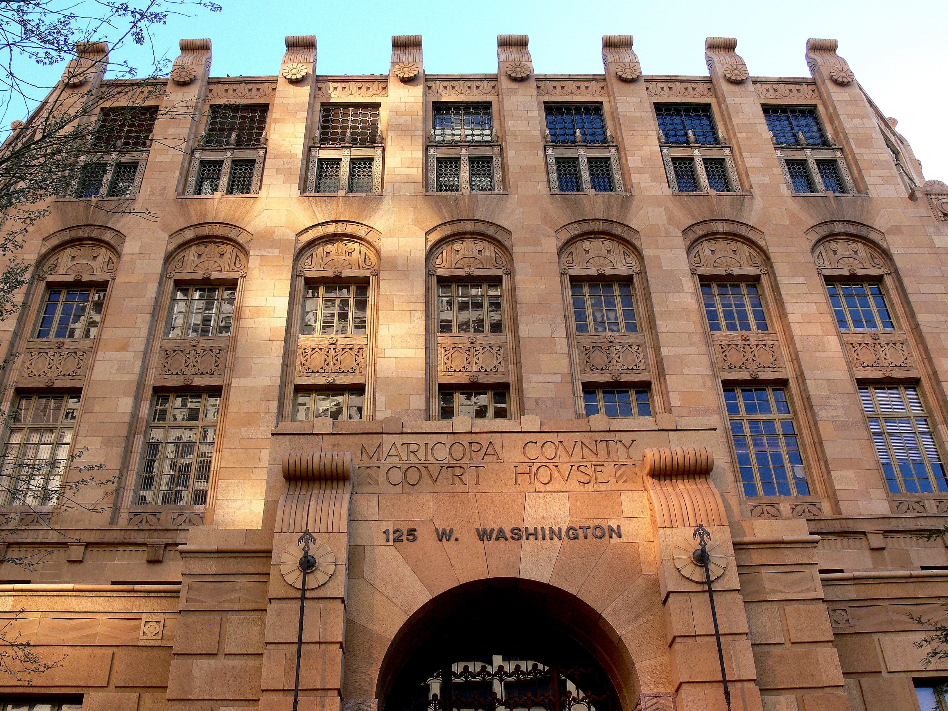
Maricopa County, Arizona 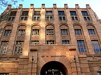 Maricopa County Courthouse in Phoenix
Flag
Seal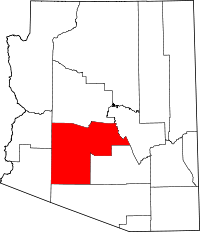
Location in the state of Arizona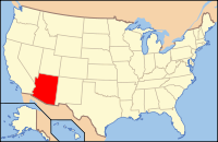
Arizona's location in the U.S.Founded February 14, 1871 Seat Phoenix Area
- Total
- Land
- Water
9,224.27 sq mi (23,891 km²)
9,203.14 sq mi (23,836 km²)
21.13 sq mi (55 km²), 0.23%Population
- (2010)
- Density
3,817,117
415/sq mi (160.1/km²)Website www.maricopa.gov Maricopa County (
 /ˌmærɨˈkoʊpə/ marr-i-koh-pə) is located in the south-central part of the U.S. state of Arizona. As of April 1, 2010, its population is an estimated 3,817,117, the most populous in the state,[1] which ranks fourth among the nation's counties and is greater than the population of 23 states.[2] Maricopa County is also one of the largest counties in the United States by area having a land area greater than that of seven states. The county seat is Phoenix,[3] which is Arizona's largest city and capital. The center of population of Arizona is located in Maricopa County, in the town of Gilbert.[4] It is by far Arizona's most populous county, encompassing well more than half of the state's residents.
The population explosion is evident in a 2007 Forbes study which ranked four of Maricopa County's municipalities in the top ten fastest-growing cities in the nation. Those included Buckeye as the second-fastest-growing city, Surprise and Goodyear as 3rd and 4th, and Avondale as 9th.[5] All four of these cities are located in the growing "West Valley", which is the area of Maricopa County to the west of the city of Phoenix.
There are five Indian reservations located in the county.[6] The largest of these are the Salt River Pima-Maricopa Indian Community (east of Scottsdale) and the Gila River Indian Community (south of Phoenix).
Contents
Geography
According to the 2000 census, the county has a total area of 9,224.27 square miles (23,890.7 km2), of which 9,203.14 square miles (23,836.0 km2) (or 99.77%) is land and 21.13 square miles (54.7 km2) (or 0.23%) is water.[7]
Major Highways
 Interstate 8
 Interstate 10
 Interstate 17
 U.S. Route 60
 Loop 101
 Loop 202
 Loop 303
 State Route 51
 State Route 71
 State Route 74
 State Route 85
 State Route 87
 State Route 143
 State Route 347
Other roads
- MC-85 (Buckeye Road) Runs from the Phoenix Sky Harbor Airport to Buckeye, AZ
- Historic Route 80 runs from Buckeye to Gila Bend
- Salome Highway connects Old US 80 travelers to I-10 and US 60
- Sun Valley Parkway runs from Buckeye to Surprise, Arizona. Buckeye Residents use this highway to avoid 1-10/Loop 303 traffic.
Adjacent counties
- La Paz County, Arizona - west
- Yuma County, Arizona - west
- Pima County, Arizona - south
- Pinal County, Arizona - southeast
- Gila County, Arizona - east
- Yavapai County, Arizona - north
National protected areas
- Sonoran Desert National Monument (part)
- Tonto National Forest (part)
Demographics
Historical populations Census Pop. %± 1880 5,689 — 1890 10,986 93.1% 1900 20,457 86.2% 1910 34,488 68.6% 1920 89,576 159.7% 1930 150,970 68.5% 1940 186,193 23.3% 1950 331,770 78.2% 1960 663,510 100.0% 1970 971,228 46.4% 1980 1,509,175 55.4% 1990 2,122,101 40.6% 2000 3,072,149 44.8% 2010 3,817,117 24.2% source:[8] 2010
Whereas according to the 2010 U.S. Census Bureau:
- 73.0% White
- 5.0% Black
- 2.1% Native American
- 3.5% Asian
- 0.2% Native Hawaiian or Pacific Islander
- 3.5% Two or more races
- 12.7% Other races
- 29.6% Hispanic or Latino (of any race)
2000
As of the census[9] of 2000, there were 3,072,149 people, 1,132,886 households, and 763,565 families residing in the county. The population density was 334 people per square mile (129/km²). There were 1,250,231 housing units at an average density of 136/sq mi (52/km²). The racial makeup of the county was 77.35% White, 3.73% African American, 1.85% Native American, 2.16% Asian, 0.14% Pacific Islander, 11.86% from other races, and 2.91% from two or more races. 29.5% of the population were Hispanic or Latino of any race. 19.10% reported speaking Spanish at home.[10]
There were 1,132,886 households out of which 33.00% had children under the age of 18 living with them, 51.60% were married couples living together, 10.70% had a female householder with no husband present, and 32.60% were non-families. 24.50% of all households were made up of individuals and 7.90% had someone living alone who was 65 years of age or older. The average household size was 2.67 and the average family size was 3.21.
The population was spread out with 27.00% under the age of 18, 10.20% from 18 to 24, 31.40% from 25 to 44, 19.80% from 45 to 64, and 11.70% who were 65 years of age or older. The median age was 33 years. For every 100 females there were 100.10 males. For every 100 females age 18 and over, there were 98.10 males.
The median income for a household in the county was $45,358, and the median income for a family was $51,827. Males had a median income of $36,858 versus $28,703 for females. The per capita income for the county was $22,251. About 8.00% of families and 11.70% of the population were below the poverty line, including 15.40% of those under age 18 and 7.40% of those age 65 or over.
2005 estimate
Source:[11] *Non Hispanic (61.0%):
- White (Non-Hispanic): 61.5%
- Black: 4.3%
- Asian: 2.7%
- American Indian and Alaska Native persons, percent: 2.2%
- Native Hawaiian and Other Pacific Islander: 0.2%
- Persons of Two or more Races: 1.6%
- Hispanic: 30.1%
- As of July 1, 2005, Maricopa County had 3,635,528; an 18% change from 2000. Males accounted for 50.3% of the population, and females accounted for 49.7%.[11]
- As of July 1, 2005:
- 27.4% of the population was under 18 years of age.
- 61.5% of the population was between 19 and 64 years of age
- 11.1% of the population was over 65 years of age.
Politics
Presidential elections results Year Republican Democratic 2008 54.4% 746,448 43.9% 602,166 2004 57.0% 679,455 42.3% 504,849 2000 53.2% 479,967 42.9% 386,683 1996 47.2% 386,015 44.5% 363,015 1992 41.4% 360,049 32.6% 285,457 1988 64.9% 442,337 33.9% 230,952 1984 72.0% 411,902 27.1% 154,833 1980 65.0% 316,287 34.5% 119,752 1976 61.7% 258,262 35.3% 144,613 1972 69.3% 244,593 27.0% 95,135 1968 59.1% 161,262 31.4% 86,204 1964 53.9% 143,114 46.0% 122,042 Maricopa County has a long history of being a Republican Party stronghold. While the city of Phoenix leans towards the Democratic Party, along with some other small areas within the county, the rest of the county tends to vote heavily Republican. Every Republican presidential candidate has carried Maricopa County since 1948. This includes the 1964 presidential run of native son Barry Goldwater; who would not have even carried his own state had it not been for a 21,000-vote margin in Maricopa County. In 2008, the county was the most populous in the nation to be won by John McCain over Barack Obama.
Despite its political leanings, Maricopa County voted against Proposition 107 in the 2006 election. This referendum, designed to ban gay marriage and restrict domestic partner benefits, was rejected by a slim 51.6%-48.4% margin within the county, and statewide by a similar margin. Two years later, however, a majority of county residents voted to pass the ultimately successful state constitutional amendment banning same-sex marriage.
The County Board of Supervisors consists of five members chosen by popular vote within their own districts. Currently, the Board consists of four Republicans, each representing districts in the more affluent or conservative districts of the county, and one Democrat, representing the largest district.[citation needed] Each member serves for a period of four years, and may be continuously reelected. The Board of Supervisors acts in the capacity of executive authority for the county within the statutes and powers prescribed by Arizona state law. In this respect the Legislature of the State of Arizona is, in effect, the legislative body of the county, with limited discretion granted to the Board of Supervisors on minor ordinance and revenue collection issues. Chair of the Board is held by one member for a period of one year, and is selected by the Board members themselves through public hearing. Unlike cities and towns in Arizona, each county is not a chartered government and is considered both politically and legally a sub-division of the state.
The election of the County Sheriff, County Attorney, County Assessor, County Treasurer, Superintendent of Schools, County Recorder, Constables, Justices of the Peace, Clerk of the Superior Court, and retention of Superior Court Judges are also determined by popular vote.
The current sheriff is Joe Arpaio, who has labeled himself "America's Toughest Sheriff" due to his flamboyant and often controversial management of office.[12]
As Maricopa County is home to almost 60 percent of the state's population, it dominates Arizona's politics. Six of the state's eight congressional districts take in significant portions of the county, and most of the state's most prominent elected officials live there.
Transportation
Main article: Metropolitan Phoenix FreewaysThe county is served by three interstates (Interstate 8, Interstate 10, and Interstate 17), one U.S. Highway (US 60), and several state highways (SR 51, SR 74, SR 85, SR 87, SR 143, Loop 101, Loop 202, and Loop 303).
Communities
Cities
- Apache Junction (most of Apache Junction is in Pinal County)
- Avondale
- Chandler
- El Mirage
- Glendale
- Goodyear
- Litchfield Park
- Mesa
- Peoria (part of Peoria is in Yavapai County)
- Phoenix
- Scottsdale
- Surprise
- Tempe
- Tolleson
Towns
- Buckeye
- Carefree
- Cave Creek
- Fountain Hills
- Gila Bend
- Gilbert
- Guadalupe
- Paradise Valley
- Queen Creek (part of Queen Creek is in Pinal County)
- Wickenburg
- Youngtown
Census-designated places
Other communities
- Aguila
- Anthem
- Arlington
- Circle City
- Co-op Village
- Higley
- Komatke
- Laveen
- Liberty
- Mobile
- Morristown
- Palo Verde
- Theba
- Tonopah
- Tortilla Flat
- Waddell
- Wintersburg
- Wittmann
Future developments
Douglas Ranch { planned for 300,000 inhabitants}.[13]
Education
Maricopa County Library District operates the county libraries in Maricopa County.
See also
- Maricopa County Sheriff's Office
- National Register of Historic Places listings in Maricopa County, Arizona
- USS Maricopa County (LST-938)
- White Tank Mountain Regional Park
References
- ^ "Maricopa County 2010 US Census Bureau". Quickfacts.census.gov. http://2010.census.gov/2010census/data/. Retrieved 2011-02-20.
- ^ US county census
- ^ "Find a County". National Association of Counties. http://www.naco.org/Counties/Pages/FindACounty.aspx. Retrieved 2011-06-07.
- ^ Arizona Center of Population Ceremony, Arizona Geographic Information Council, 2005-06-15. Retrieved 2007-12-17.
- ^ Woolsey, Matt. - "America's Fastest-Growing Suburbs". - Forbes. - July 16, 2007.
- ^ Indian Reservations in the Continental United States, Bureau of Indian Affairs on National Park Service website. Retrieved 2009-01-18.
- ^ "Census 2000 U.S. Gazetteer Files: Counties". United States Census. http://www.census.gov/tiger/tms/gazetteer/county2k.txt. Retrieved 2011-02-13.
- ^ Gibson, Campbell. "Population of the 100 Largest Cities and Other Urban Places in the United States: 1790 to 1990." United States Census Bureau. June, 1998. Retrieved on October 7, 2006.
- ^ "American FactFinder". United States Census Bureau. http://factfinder.census.gov. Retrieved 2008-01-31.
- ^ mla.org
- ^ a b census.gov
- ^ Joseph M. Arpaio, Maricopa County Sheriff's Office, 2005. Retrieved 2007-12-12.
- ^ Padgett, mike (May 16, 2003). "Buckeye history favored as future projects unfold". http://phoenix.bizjournals.com/phoenix/stories/2003/05/19/story6.html. Retrieved May 16, 2003.

Yavapai County La Paz County and Yuma County 
Gila County  Maricopa County, Arizona

Pima County Pinal County Phoenix Metropolitan Area Core city Largest suburbs
(over 100,000 inhabitants)Other suburbs and towns
(over 10,000 inhabitants)Anthem • Apache Junction • Avondale • Buckeye • Casa Grande • El Mirage • Eloy • Florence • Fountain Hills • Goodyear • Gold Canyon • Luke Air Force Base • Maricopa • New River • Paradise Valley • Queen Creek • San Tan Valley • Sun City • Sun City West • Sun LakesSmaller suburbs and towns
(over 5,000 inhabitants)Black Canyon City • Carefree • Cave Creek • Coolidge • Gila Bend • Guadalupe • Laveen • Litchfield Park • Superior • Tolleson • Wickenburg • YoungtownCounties Maricopa • Pinal State of Arizona
Phoenix (capital) Topics Index | Climate | Delegations | Geography | History | Museums | Music | People | Transportation | Visitor Attractions
Society Culture · Demographics · Economy · Education · Politics
Regions Arizona Strip | Arizona Sun Corridor | Coconino Plateau | Colorado Plateau | Grand Canyon | Kaibab Plateau | Mogollon Plateau | Mogollon Rim | Mojave Desert | Monument Valley | North Central Arizona | Northeast Arizona | Northern Arizona | Oak Creek Canyon | Phoenix Metropolitan Area | Safford area | San Francisco Volcanic Field | Sonoran Desert | Southern Arizona | Verde Valley | White Mountains
Counties Cities Chandler | Flagstaff | Gilbert | Glendale | Kingman | Lake Havasu City | Mesa | Peoria | Phoenix | Prescott | Scottsdale | Sierra Vista | Tempe | Tucson | Yuma
Coordinates: 33°30′50″N 112°28′33″W / 33.51389°N 112.47583°W
Categories:- Arizona counties
- Maricopa County, Arizona
- 1871 establishments


Wikimedia Foundation. 2010.