- Arizona State Route 347
Infobox road
marker_
state=AZ
highway_name=
name_notes=
type=state
route=347
alternate_name=
maint=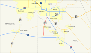
length_mi=28.50
length_round=2
length_ref=cite web |url=http://tpd.az.gov/data/reports/2006SHSLog.pdf |title=2006 ADOT Highway Log |author=Arizona Department of Transportation |accessdate=2008-04-08]
length_notes=
established=
decommissioned=
direction_a=South
starting_terminus=jct|state=AZ|SR|84 near Stanfield
junction=
direction_b=North
ending_terminus=jct|state=AZ|I|10 near Sun Lakes
previous_type=AZ
previous_route=303
next_type=AZ
next_route=360
commons=State Route 347, also known as SR 347, Maricopa Road, and John Wayne Parkway, is a north-south state highway in central
Arizona . It stretches from its northern terminus at Interstate 10 south of Chandler south to its junction with State Route 84 near Stanfield. It primarily serves as the major road to Maricopa; much of the road lies within theGila River Indian Community , with another short stretch through theAk-Chin Indian Community .While most three-digit Arizona State Routes are numbered as branches of a two-digit highway, SR 347 is actually numbered according to the Federal Aid Secondary Route number given by the
Federal Highway Administration .Route description
The southern terminus of SR 347 is located at an intersection with SR 84 west of Stanfield. The highway heads north from this intersection towards Maricopa. It enters the
Ak-Chin Indian Community on its way to Maricopa and intersects BIA Route 14 within the community. In Maricopa, the highway begins to head towards the north-northeast prior to an intersection with SR 238. North of Maricopa, the highway enters theGila River Indian Community , where it continues to head towards the north-northeast. As the highway nears its northern terminus, it curves to the east and ends at an interchange with I-10. [cite map|publisher=Google Maps |title=Overview map of SR 347|accessdate=2008-04-14|url=http://maps.google.com/maps?f=d&hl=en&geocode=2529850674388876838,32.875060,-112.049140%3B7444233191775362588,33.254890,-111.949319&saddr=AZ-347%2FN+John+Wayne+Pkwy%2FS+Maricopa+Rd+%4032.875060,+-112.049140&daddr=W+Queen+Creek+Rd+%4033.254890,+-111.949319&doflg=ptm&jsv=107&sll=33.064975,-111.99938&sspn=0.396479,0.639954&ie=UTF8&z=11]Junction list
References
External links
* [http://arizonaroads.com/arizona/az347.html SR 347 at Arizona Roads]

Wikimedia Foundation. 2010.