- Arizona State Route 84
Infobox road
marker_
state=AZ
highway_name=
name_notes=
type=state
route=84
alternate_name=
maint=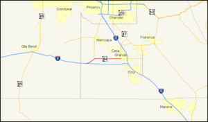
length_mi=23.68
length_round=2
length_ref=cite web |url=http://tpd.az.gov/data/reports/2006SHSLog.pdf |title=2006 ADOT Highway Log |author=Arizona Department of Transportation |accessdate=2008-04-09]
length_notes=
established=
decommissioned=
direction_a=West
starting_terminus=jct|state=AZ|I|8
junction=
direction_b=East
ending_terminus=jct|state=AZ|I|10
previous_type=AZ
previous_route=83
next_type=AZ
next_route=84A
commons=State Route 84, also known as SR 84, is an east-west highway in south-central
Arizona , with its western terminus at Exit 151 of Interstate 8 and its eastern terminus at its junction with State Route 387 and State Route 287 in Casa Grande.Route description
The western terminus of SR 84 is located at exit 151 on I-8 in southern Arizona. From this interchange, it heads towards the northeast to an intersection with SR 347 which heads north to Maricopa. SR 84 continues towards the east from this intersection passing through Stanfield on its way to Casa Grande. This segment reaches its eastern terminus at a junction with SR 287 and SR 387 in Casa Grande. [cite map|publisher=
Google Maps |title=Overview map of western segment of SR 84|accessdate=2008-04-28|url=http://maps.google.com/maps?f=d&hl=en&geocode=11220540073573732732,32.834563,-112.133135%3B1865144591654437154,32.867368,-112.062987%3B4173393174955934263,32.879400,-111.912030%3B14529810804460289440,32.879561,-111.757384&saddr=AZ-84%2FW+AZ-84+%4032.834563,+-112.133135&daddr=AZ-84%2FW+AZ-84+%4032.867368,+-112.062987+to:AZ-84%2FW+AZ-84+%4032.879400,+-111.912030+to:AZ-84%2FW+Gila+Bend+Hwy+%4032.879561,+-111.757384&via=1,2&doflg=ptm&sll=32.833894,-112.13243&sspn=0.006211,0.009999&ie=UTF8&z=11] The western terminus of the eastern segment is located between of the city of Eloy and the southern terminus of SR 87. The highway heads eastward to the junction with SR 87 before turning towards the south. SR 84 continues south to its eastern termius at exit 211 on I-10. [cite map|publisher=Google Maps |title=Overview map of eastern segment of SR 84|accessdate=2008-04-28|url=http://maps.google.com/maps?f=d&hl=en&geocode=6677945563987855807,32.734050,-111.518611%3B2520506633420118615,32.722852,-111.515909&saddr=AZ-84+E+%4032.734050,+-111.518611&daddr=Unknown+road+%4032.722852,+-111.515909&doflg=ptm&sll=32.728447,-111.51726&sspn=0.012437,0.019999&ie=UTF8&z=16]History
Until 1998, this route extended westward to Gila Bend until its replacement by Interstate 8; as such, it was known as the Gila Bend Highway and still carries that name in Casa Grande. State Route 84 formerly extended eastward as far as Tucson; this old route still exists between Tucson and Eloy as the Interstate 10 frontage road. Other portions of this are former State Route 93 from Casa Grande southeast to Eloy (Jimmie Kerr Boulevard / Frontier Street) as well as a short stretch of State Route 87 from Eloy to Interstate 10.
This road serves as the only east-west thoroughfare in
Stanfield, Arizona , but has been largely supplanted as a major road by the existence of Interstates 8 and 10.Junction list
The entire route is in Pinal County.
References
External links
* [http://arizonaroads.com/arizona/az84.html SR 84 at Arizona Roads]

Wikimedia Foundation. 2010.