- Maricopa, Arizona
-
City of Maricopa, Arizona — City — Residential developments dominate the landscape of Maricopa.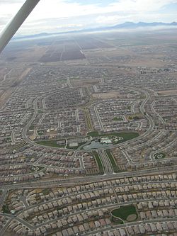 Location in Pinal County and the state of Arizona
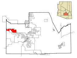
Coordinates: 33°3′24″N 112°2′48″W / 33.05667°N 112.04667°WCoordinates: 33°3′24″N 112°2′48″W / 33.05667°N 112.04667°W Country United States State Arizona County Pinal Incorporated 2003 Government - Mayor Anthony Smith - Vice-Mayor Edward Farrell - City Council Marvin Brown, Carl Diedrich, Marquisha Griffin, Julia Romero-Gusse, Alan Marchione - City Manager Brenda Fischer - City Clerk Vanessa Bueras Area - Total 31.9 sq mi (82.6 km2) - Land 31.9 sq mi (82.6 km2) - Water 0.0 sq mi (0.0 km2) Elevation 1,190 ft (358 m) Population (2010)[1] - Total 43,482 - Density 1,356.8/sq mi (847.6/km2) Time zone MST (no DST) (UTC-7) ZIP code 85139, 85138 Area code(s) 520 FIPS code 04-44410 Website http://www.maricopa-az.gov/ http://www.inmaricopa.com/ Maricopa is a city in the Gila River Valley in the U.S. state of Arizona. Incorporated in 2003, it is the nineteenth largest city in the state with a population of 43,482 as of April 2010.[1] Maricopa is the second most populous incorporated city in Pinal County and forms part of the Phoenix metropolitan area, the 12th largest metropolitan area in the United States.
Contents
History
Maricopa has had three locations over the years: Maricopa Wells, Maricopaville and Maricopa Junction which gradually became known as Maricopa. Each stage of its life has contributed greatly to the growth and development of the Southwest.[2] Its conception took place at a series of watering holes eight miles north of present day Maricopa, and about a mile west of Pima Butte. It was called Maricopa Wells. Several of Arizona’s rivers, the Gila, Santa Cruz, Vekol and Santa Rosa provided this oasis in the desert with an ample supply of water during this period of time.
Maricopa Wells was one of the most important relay stations along the San Antonio-San Diego Mail Line and the later more famous Butterfield Overland Mail Route during the 1800s. Although little remains of this once bustling community, it played an important part in the progress and development of the southwest. It was one of the best known spots in Arizona during this period of time because it not only had a reliable source of water, but offered an abundance of food thanks to the peaceful Pima and Maricopa farmers who lived and farmed nearby.
The most prosperous period of time for Maricopa Wells was in the 1870s. During this time the Wells provided water and food for not only the east-west travelers, but those who traveled to the north. Fairly good roads had been built by James A. Moore, the proprietor at Maricopa Wells, to all points north and the Wells was a constant hubbub of activity. With its ample supply of water and prosperous trading center, it truly was a shining beacon and sanctuary in the desert for those thousands of travelers who depended upon its resources for their survival.
Maricopa’s second moment of fame took place eight miles south of Maricopa Wells and about three miles west of present day Maricopa. It was called Maricopaville. In 1879, the Southern Pacific Railroad was in the process of building a railroad line from Yuma to Tucson, and a second railroad line was to be built from Maricopaville, wrapping around the western edge of South Mountain into Phoenix. It didn’t take long for this little desert settlement of Maricopaville to take on the appearance of one of the gold rush boom towns of California with men working day and night building hotels, saloons, warehouses, restaurants, theaters, etc. One newspaper of the times reckoned that with its thousands of people and good location, it would be an ideal choice for the location of the state capitol.
However, a railroad line was never built from Maricopaville into Phoenix. Tempe wanted to be on the railroad line and was very vociferous about its demands and rights. The powers at the state capitol agreed and Maricopaville lost its moment of glory as a rising Arizona star. It was moved three miles to the east to its present location of Maricopa in the early 1880s, and began its life as a famous railroad junction when the first M&P train left Maricopa for Phoenix on July 4, 1887. Once again, all east-west travelers had to stop at Maricopa, and those who wanted to travel to the north had to board the Maricopa & Phoenix Railroad which took them into Kyrene, Tempe and Phoenix.[3][4][5]
The city was officially incorporated on October 15, 2003, becoming the 88th incorporated city in Arizona. The 2010 Census shows Maricopa growing from 1,040 residents in 2000 to 43,482, an increase of 4080%.[1]
Media coverage
Maricopa was the subject of a major article in the New York Times on April 6, 2008, and the town was featured on ABC's Nightline on May 7, 2008, during its "Realty Check" segment.[6] The story dealt with the drastic effect of the subprime mortgage crisis and housing market correction on the city. In the story, Maricopa was referred to as the "poster child of the housing crisis."
Geography and climate
Maricopa is located at 33°3′24″N 112°2′48″W / 33.05667°N 112.04667°W (33.056702, -112.046656)[7].
According to the United States Census Bureau, the city has a total area of 31.9 square miles (83 km2), all of it land.[8]
The topography in Maricopa is flat with several mountain ranges 10 to 20 miles away. The elevation of Maricopa is 1190 feet.
Climate data for Maricopa, AZ Month Jan Feb Mar Apr May Jun Jul Aug Sep Oct Nov Dec Year Average high °F (°C) 67
(19)72
(22)77
(25)86
(30)95
(35)105
(41)107
(42)105
(41)100
(38)89
(32)75
(24)67
(19)87.08 Average low °F (°C) 35
(2)39
(4)44
(7)49
(9)58
(14)67
(19)76
(24)75
(24)66
(19)53
(12)40
(4)34
(1)53 Precipitation inches (mm) 0.75
(19.1)0.8
(20)1.04
(26.4)0.26
(6.6)0.14
(3.6)0.11
(2.8)0.96
(24.4)0.89
(22.6)0.76
(19.3)0.66
(16.8)0.63
(16)0.98
(24.9)7.98
(202.7)Source: The Weather Channel[9] Surrounding Municipalities

Goodyear Gila River Indian Community Gila River Indian Community Ak-Chin Village 
Gila River Indian Community  Maricopa

Palo Verde Mountains Stanfield Casa Grande Demographics
Historical populations Census Pop. %± 2000 1,040 — 2010 43,482 4,081.0% As of the census[10] of 2010, there were 43,482 people, 14,359 households, and 11,110 families residing in the city. The population density was 1,356.8 people per square mile (526.4/km2). There were 17,240 housing units at an average density of 540.4 per square mile (208.7/km2). The racial makeup of the city was 70.2% White, 9.7% Black or African American, 2.0% Native American, 4.1% Asian, 0.3% Pacific Islander, 8.5% from other races, and 5.3% from two or more races. 24.4% of the population is Hispanic or Latino of any race. [11]
There were 14,359 households out of which 47.1% had children under the age of 18 living with them, 37.5% were married couples living together, 10.9% had a female householder with no husband present, and 22.6% were non-families. 15.6% of all households were made up of individuals and 2.5% had someone living alone who was 65 years of age or older. The average household size was 3.03 and the average family size was 3.38.[11]
In the city the population was spread out with 32.5% under the age of 18, 6.2% from 18 to 24, 35% from 25 to 44, 19.8% from 45 to 64, and 6.5% who were 65 years of age or older. The median age was 31.2 years. For every 100 females there were 98.5 males. For every 100 females age 18 and over, there were 94.8 males.
According to 2009 Census Bureau estimates, the median income for a household in the city was $67,692, and the median income for a family was $69,818. The per capita income for the city was $27,618. About 3.7% of families and 5.2% of the population were below the poverty line.[12]
Transportation
Highways to Maricopa include Arizona State Route 238 and Arizona State Route 347. Maricopa lies approximately 15 miles west of Interstate 10 and 15 miles north of Interstate 8. MaricopaXPress, a bus service operated by the city and Pinal County, offers two roundtrips to Phoenix geared towards commuters.[13]
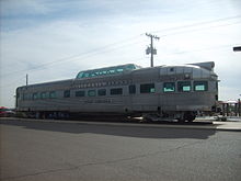
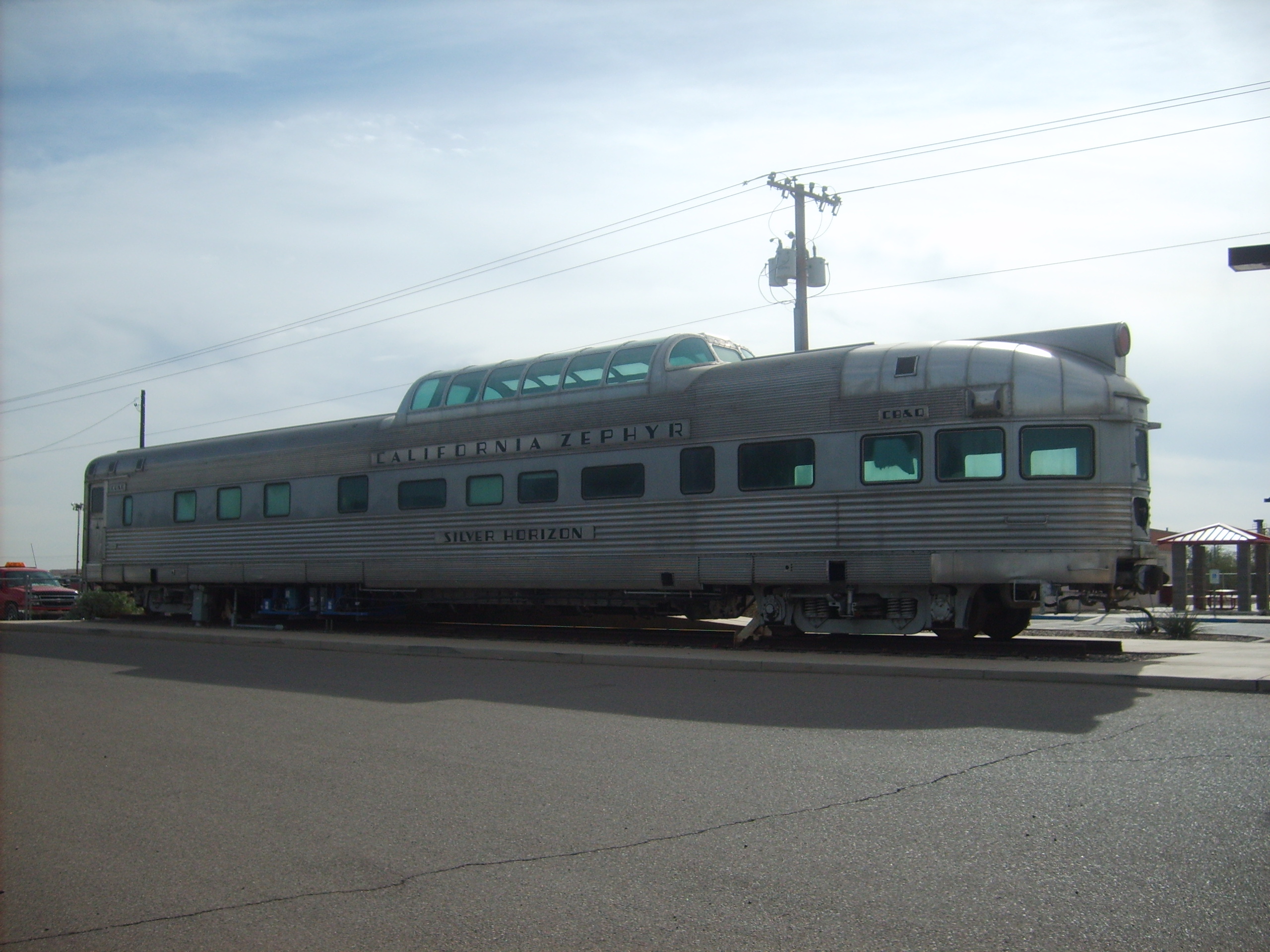
Maricopa is currently the closest stop from Phoenix on AMTRAK's Sunset Limited and Texas Eagle trains. The Maricopa depot opened in 2001, originally in a converted passenger rail car but now in a metal building.
Civic and Non Profit Organizations
- F.O.R. Maricopa - local food bank
- Pet Social Worker / Tails of Hope Rescue - local animal rescue group
Education Facilities
Public Elementary School
- Butterfield Elementary School
- Maricopa Elemenatry School
- Pima Butte Elementary School
- Saddleback Elementary School
- Santa Cruz Elementary School
- Santa Rosa Elementary School
Public Middle School
- Desert Wind Middle School
- Maricopa Wells Middle School
Public High School
Public School District
Notable people
- Antony Hämäläinen, vocalist for Greek/Swedish Melodic Death Metal band Nightrage[14].
- Joe Veres, former UFC fighter
- Bristol Palin, the daughter of former Alaska governor Sarah Palin [14].
- Joshua Fourrier, nationally syndicated radio talk show host.[15]
Notes
- ^ a b c "U.S. Census Data". United States Census Bureau. 2011-03-10. http://2010.census.gov/news/xls/cb11cn76_az_2010redistr.xls. Retrieved 2011-03-10.
- ^ Citation?
- ^ Reflections of a Desert Town, Patricia Brock
- ^ http://www.maricopachamber.org/futureresident/history.php
- ^ http://www.inmaricopa.com/COMMUNITY/History/tabid/131/Default.aspx
- ^ Rooney, Brian (2008-05-07). "Poster Child for Housing Crisis: 'They Were Building Mortgages' in Arizona Town". Nightline. http://www.abcnews.go.com/Business/RealtyCheck/story?id=4798588&page=1. Retrieved 2008-05-08.
- ^ "US Gazetteer files: 2010, 2000, and 1990". United States Census Bureau. 2011-02-12. http://www.census.gov/geo/www/gazetteer/gazette.html. Retrieved 2011-04-23.
- ^ http://factfinder2.census.gov/faces/tableservices/jsf/pages/productview.xhtml?pid=DEC_10_DP_G001&prodType=table
- ^ "Monthly Averages for Maricopa, AZ". Weather.com. 2010. http://www.weather.com/weather/wxclimatology/monthly/graph/USAZ0131. Retrieved 2010-04-16.
- ^ "American FactFinder". United States Census Bureau. http://factfinder.census.gov. Retrieved 2008-01-31.
- ^ a b http://factfinder2.census.gov/faces/tableservices/jsf/pages/productview.xhtml?pid=DEC_10_DP_DPDP1&prodType=table
- ^ http://factfinder.census.gov/servlet/ACSSAFFFacts?_event=ChangeGeoContext&geo_id=16000US0444410&_geoContext=&_street=&_county=maricopa&_cityTown=maricopa&_state=04000US04&_zip=&_lang=en&_sse=on&ActiveGeoDiv=&_useEV=&pctxt=fph&pgsl=010&_submenuId=factsheet_1&ds_name=ACS_2009_5YR_SAFF&_ci_nbr=null&qr_name=null®=null%3Anull&_keyword=&_industry=
- ^ MaricopaXpress Bus Service
- ^ a b Kelly, Liz. Bristol Palin headed to Arizona
- ^ . Compete Sports Radio Network. AZCentral.com, March 01, 2011. Retrieved 2011-03-02.
External links
- City of Maricopa
- Maricopa Chamber of Commerce
- InMaricopa.com - Maricopa's first source for news and information
- Maricopa Monitor - Twice a week newspaper - Founded in 2003
- WikiSatellite view of Maricopa at WikiMapia
- Maricopa360.com - Local News, Events, and Commentary
- Maricopa Off Road Club
Municipalities and communities of Pinal County, Arizona County seat: Florence Cities Apache Junction‡ | Casa Grande | Coolidge | Eloy | Maricopa

Towns CDPs Ak-Chin Village | Arizona City | Blackwater | Cactus Forest | Campo Bonito | Casa Blanca | Chuichu | Dudleyville | Gold Canyon | Goodyear Village | Kohatk | Oracle | Picacho | Queen Valley | Red Rock | Sacaton | Sacaton Flats Village | Saddlebrooke | San Manuel | Santa Cruz | Santan | San Tan Valley | Stanfield | Stotonic Village | Sweet Water Village | Tat Momoli | Top-of-the-World‡ |
Unincorporated
communitiesBapchule | Chandler Heights‡ | Randolph | Valley Farms
Indian reservations Ghost towns American Flag | Cochran | Copper Creek | Pinal City | Ray | Reymert | Sasco | Tiger
Footnotes ‡This populated place also has portions in an adjacent county or counties
Phoenix Metropolitan Area Core city Largest suburbs
(over 100,000 inhabitants)Other suburbs and towns
(over 10,000 inhabitants)Anthem • Apache Junction • Avondale • Buckeye • Casa Grande • El Mirage • Eloy • Florence • Fountain Hills • Goodyear • Gold Canyon • Luke Air Force Base • Maricopa • New River • Paradise Valley • Queen Creek • San Tan Valley • Sun City • Sun City West • Sun LakesSmaller suburbs and towns
(over 5,000 inhabitants)Black Canyon City • Carefree • Cave Creek • Coolidge • Gila Bend • Guadalupe • Laveen • Litchfield Park • Superior • Tolleson • Wickenburg • YoungtownCounties Categories:- Cities in Arizona
- Former census-designated places in Arizona
- Populated places in Pinal County, Arizona
- Butterfield Overland Mail


Wikimedia Foundation. 2010.