- Arizona State Route 80
Infobox road
marker_
state=AZ
highway_name=
name_notes=
type=state
route=80
alternate_name=
maint=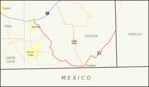
length_mi=120.23
length_round=2
length_ref=cite web |url=http://tpd.az.gov/data/reports/2006SHSLog.pdf |title=2006 ADOT Highway Log |author=Arizona Department of Transportation |accessdate=2008-04-09|format=PDF]
length_notes=
established=1989cite web|url=http://www.azhighwaydata.com/resolutions/?resnum=1989-12-A-096|title=ADOT Right-of-Way Resolution 1989-12-A-096|accessdate=2008-05-03|author=Arizona Department of Transportation ]
decommissioned=
direction_a=West
starting_terminus=jct|state=AZ|BL|10|dab1=Benson near Benson
junction=jct|state=AZ|US|191 in Douglas
direction_b=East
ending_terminus=jct|state=NM|NM|80
previous_type=AZ
previous_route=79
next_type=AZ
next_route=81
commons=State Route 80 (SR 80) is a roughly arc-shaped highway lying in southeastern
Arizona that, withNew Mexico 's State Road 80, is a relic of the old U.S. Route 80, now truncated from San Diego to Dallas. This segment of old US 80 was not closely paralleled by Interstate 10, which lies to its north, and instead supplants the old and more direct (defunct in eastern Arizona) State Route 86.Route description
Its western terminus is on Interstate 10 at Benson, Arizona; the eastern terminus is on the
New Mexico state line. It passes through Tombstone, the (in)famousWild West town, Bisbee, and Douglas on the border with theMexican federal state ofSonora and in which it meets U.S. Route 191. All of it is surface road, and it is the route of theButterfield Stage Coach of the nineteenth century, and the Old Spanish Trail.It is not a very direct route; west of Douglas it is almost as much a north-south route as an east-west route, and it is practically a north-south route east of Douglas.
History
SR 80 was originally conceived as part of the proposed state system of highway in 1919.cite map|publisher=Arizona Highway Department|url=http://www.rockymountainroads.com/maps/1919-az.html|title=Map of Proposed State Highway System of Arizona|year=1919|accessdate=2008-05-03] In 1926, it became part of the cross-country highway US 80. The road was paved at this time between Douglas and Bisbee as well as a portion south of Tombstone. The remainder of the highway was a gravel road.cite map|url=http://www.rockymountainroads.com/maps/1926-az.html|title=Map of Arizona|year=1926|publisher=Arizona Highway Department|accessdate=2008-05-03] By 1931, the highway was paved from Bisbee to the New Mexico state line as well as a portion south of Benson and another portion south of Tombstone.cite map|url=http://www.rockymountainroads.com/maps/1931-az.html|title=Condition Map of State Highway System|year=1931|publisher=Arizona Highway Department|accessdate=2008-05-03] By 1934, the only portion of the highway yet to be paved was a section between Tombstone and Bisbee.cite map|url=http://www.rockymountainroads.com/maps/1934-az.html|title=Condition Map of State Highway System|year=1934|publisher=Arizona Highway Department|accessdate=2008-05-03] The entire route had been paved by 1935.cite map|url=http://www.arizonaroads.com/maps/index.html|title=Road Map of Arizona|year=1935|publisher=Arizona Highway Department|accessdate=2008-05-03] The highway would continue to serve as a portion of US 80 until 1989 when the last portion of US 80 in Arizona was removed. This portion of the highway was redesignated as SR 80 at this time.
Junction list
The entire route is in Cochise County.
References

Wikimedia Foundation. 2010.