- Navajo County, Arizona
-
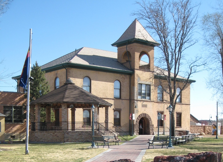
Navajo County, Arizona  Historic Navajo County Courthouse and Museum in Holbrook, Arizona
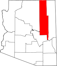
Location in the state of Arizona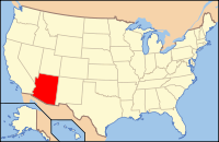
Arizona's location in the U.S.Founded March 21, 1895 Seat Holbrook Area
- Total
- Land
- Water
9,959.49 sq mi (25,795 km²)
9,953.18 sq mi (25,779 km²)
6.31 sq mi (16 km²),Population
- (2010)
- Density
107,449
10/sq mi (4/km²)Website www.navajocountyaz.gov/ Navajo County is located in the northern part of the U.S. state of Arizona. As of the 2010 census its population was 107,449. The county seat is Holbrook.
Navajo County contains parts of the Hopi Indian reservation, the Navajo Nation and Fort Apache Indian Reservation.
Contents
History
Navajo County was split from Apache County on March 21, 1895. The first county sheriff was legendary gunman Commodore Perry Owens, who had previously served as the sheriff of Apache County. It was the location for many of the events that played out during the Pleasant Valley War.
Geography
According to the 2000 census, the county has a total area of 9,959.49 square miles (25,795.0 km2), of which 9,953.18 square miles (25,778.6 km2) (or 99.94%) is land and 6.31 square miles (16.3 km2) (or 0.06%) is water.[1]
Many people think that Arizona is a vast, open desert without vegetation. However, Navajo County offers not only the Monument Valley, but Keams Canyon, part of the Petrified Forest National Park, and the largest stand of Ponderosa Pines in North America.[citation needed]
Major highways
 Interstate 40
 U.S. Route 60
 U.S. Route 160
 U.S. Route 163
 U.S. Route 180
 State Route 77
 State Route 87
 State Route 98
 State Route 99
 State Route 260
 State Route 264
 State Route 277
 State Route 377
Adjacent counties
- Apache County, Arizona - east
- Graham County, Arizona - south
- Gila County, Arizona - southwest
- Coconino County, Arizona - west
- San Juan County, Utah - north
Indian reservations
Navajo County has 6,632.73 square miles (17,178.7 km2) of federally designated Indian reservation within its borders, the third most of any county in the United States (neighboring Apache County and Coconino County are first and second). In descending order of territory within the county, the reservations are the Navajo Indian Reservation, Hopi Indian Reservation, and Fort Apache Indian Reservation, all of which are partly located within Navajo County.
National protected areas
 Petroglyphs at Rock Art Canyon Ranch near Winslow
- Apache-Sitgreaves National Forest (part)
- Navajo National Monument
- Petrified Forest National Park (part)
Demographics
Historical populations Census Pop. %± 1900 8,829 — 1910 11,471 29.9% 1920 16,077 40.2% 1930 21,202 31.9% 1940 25,309 19.4% 1950 29,446 16.3% 1960 37,994 29.0% 1970 47,715 25.6% 1980 67,629 41.7% 1990 77,658 14.8% 2000 97,470 25.5% 2010 107,449 10.2% 2010
Whereas according to the 2010 U.S. Census Bureau:
- 49.3% White
- 0.9% Black
- 43.4% Native American
- 0.5% Asian
- 0.1% Native Hawaiian or Pacific Islander
- 2.5% Two or more races
- 3.3% Other races
- 10.8% Hispanic or Latino (of any race)
2000
As of the census[2] of 2000, there were 97,470 people, 30,043 households, and 23,073 families residing in the county. The population density was 10 people per square mile (4/km²). There were 47,413 housing units at an average density of 5 per square mile (2/km²). The racial makeup of the county was 47.74% Native American, 45.91% White, 0.88% Black or African American, 0.33% Asian, 0.05% Pacific Islander, 3.15% from other races, and 55.94% from two or more races. 8.22% of the population were Hispanic or Latino of any race. 24.77% reported speaking Navajo at home, 5.94% other Southern Athabaskan languages, 4.71% Spanish, and 3.23% Hopi [1].
There were 30,043 households out of which 40.50% had children under the age of 18 living with them, 55.50% were married couples living together, 16.30% had a female householder with no husband present, and 23.20% were non-families. 19.90% of all households were made up of individuals and 7.20% had someone living alone who was 65 years of age or older. The average household size was 3.17 and the average family size was 3.68.
In the county the population was spread out with 35.40% under the age of 18, 8.80% from 18 to 24, 25.30% from 25 to 44, 20.40% from 45 to 64, and 10.00% who were 65 years of age or older. The median age was 30 years. For every 100 females there were 98.70 males. For every 100 females age 18 and over, there were 97.20 males.
The median income for a household in the county was $28,569, and the median income for a family was $32,409. Males had a median income of $30,509 versus $21,621 for females. The per capita income for the county was $11,609. About 23.40% of families and 29.50% of the population were below the poverty line, including 36.60% of those under age 18 and 20.30% of those age 65 or over.
Communities
Cities
Towns
Census-designated places
- Chilchinbito
- Cibecue
- Dilkon
- East Fork
- First Mesa
- Greasewood
- Heber-Overgaard
- Hotevilla-Bacavi
- Jeddito
- Kayenta
- Keams Canyon
- Kykotsmovi Village
- McNary
- Oljato-Monument Valley
- Pinon
- Second Mesa
- Shongopovi
- Shonto
- Whiteriver
- Winslow West
Other communities
Education
School districts that serve the county include:
- Blue Ridge Unified School District
- Cedar Unified School District
- Heber-Overgaard Unified School District
- Holbrook Unified School District
- Joseph City Unified School District
- Kayenta Unified School District
- Piñon Unified School District
- Show Low Unified School District
- Snowflake Unified School District
- Whiteriver Unified School District
- Winslow Unified School District
See also
References
- ^ "Census 2000 U.S. Gazetteer Files: Counties". United States Census. http://www.census.gov/tiger/tms/gazetteer/county2k.txt. Retrieved 2011-02-13.
- ^ "American FactFinder". United States Census Bureau. http://factfinder.census.gov. Retrieved 2008-01-31.
External links

San Juan County, Utah Coconino County 
Apache County  Navajo County, Arizona

Gila County Graham County Municipalities and communities of Navajo County, Arizona Cities 
Towns CDPs Chilchinbito | Cibecue | Dilkon | East Fork | First Mesa | Greasewood | Heber-Overgaard | Hotevilla-Bacavi | Jeddito | Kayenta | Keams Canyon | Kykotsmovi Village | McNary‡ | Oljato-Monument Valley | Pinon | Second Mesa | Shongopovi | Shonto | Whiteriver | Winslow West‡
Unincorporated
communitiesClay Springs | Fort Apache | Indian Wells | Joseph City | Linden | Oraibi | Pinedale | Polacca | Sun Valley | White Mountain Lakes Estates | Woodruff
Ghost towns Brigham City | Sunset
Footnotes ‡This populated place also has portions in an adjacent county or counties
 State of Arizona
Topics - Index
- Climate
- Delegations
- Geography
- History
- Museums
- Music
- People
- Transportation
- Visitor Attractions
Society - Culture
- Demographics
- Economy
- Education
- Politics
Regions - Arizona Strip
- Arizona Sun Corridor
- Coconino Plateau
- Colorado Plateau
- Grand Canyon
- Kaibab Plateau
- Mogollon Plateau
- Mogollon Rim
- Mojave Desert
- Monument Valley
- North Central Arizona
- Northeast Arizona
- Northern Arizona
- Oak Creek Canyon
- Phoenix Metropolitan Area
- Safford area
- San Francisco Volcanic Field
- Sonoran Desert
- Southern Arizona
- Verde Valley
- White Mountains
Counties Cities Coordinates: 35°29′52″N 110°17′23″W / 35.49778°N 110.28972°W
Categories:- Arizona counties
- Navajo County, Arizona
- Populated places established in 1895


Wikimedia Foundation. 2010.