- Heber-Overgaard, Arizona
-
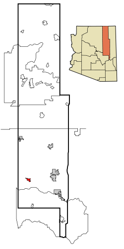
Heber-Overgaard, Arizona — CDP — Location in Navajo County and the state of Arizona Coordinates: 34°24′47″N 110°33′52″W / 34.41306°N 110.56444°WCoordinates: 34°24′47″N 110°33′52″W / 34.41306°N 110.56444°W Country United States State Arizona County Navajo Area – Total 6.9 sq mi (17.9 km2) – Land 7.0 sq mi (18.0 km2) – Water 0.0 sq mi (0.0 km2) Elevation 6,435 ft (1,961 m) Population (2000) – Total 2,722 – Density 391.4/sq mi (151.1/km2) Time zone MST (UTC-7) FIPS code 04-32310 Website http://www.heberovergaard.org/ Heber-Overgaard is a census-designated place (CDP) in Navajo County, Arizona, United States. Situated atop the Mogollon Rim, the community lies at an elevation of around 6,500 feet (2,000 m). The population was 2,722 at the 2000 census.
Heber was founded in 1876 or 1877, by members of The Church of Jesus Christ of Latter-day Saints (Mormons), and the town is named after Heber J. Grant, a prominent Mormon. The Heber post office was established in 1890.[1]
Overgaard was settled in the 1930s and was named after the owner of the first sawmill.[2] It was originally called Oklahoma Flats.[1]
Tourism, retirement and timbering are the foundations of Heber-Overgaard's economy.
Contents
Geography
Heber-Overgaard is located at 34°24′47″N 110°33′52″W / 34.41306°N 110.56444°W (34.413157, -110.564393).[3]
According to the United States Census Bureau, the CDP has a total area of 6.9 square miles (18 km2), all of it land.
In 2002, the Rodeo-Chediski fire was a wildfire that burned in Heber-Overgaard beginning on June 18, 2002, and was not controlled until July 7. It was the second worst forest fire in Arizona to date, consuming 467,066 acres (1,890.15 km2).
Demographics
As of the census[4] of 2000, there were 2,722 people, 1,154 households, and 808 families residing in the CDP. The population density was 391.4 people per square mile (151.2/km²). There were 3,178 housing units at an average density of 457.0 per square mile (176.6/km²). The racial makeup of the CDP was 94.89% White, 0.07% Black or African American, 2.31% Native American, 0.15% Asian, 0.11% Pacific Islander, 1.43% from other races, and 1.03% from two or more races. 6.06% of the population were Hispanic or Latino of any race.
There were 1,154 households out of which 22.4% had children under the age of 18 living with them, 62.4% were married couples living together, 4.9% had a female householder with no husband present, and 29.9% were non-families. 24.3% of all households were made up of individuals and 12.1% had someone living alone who was 65 years of age or older. The average household size was 2.36 and the average family size was 2.79.
In the CDP the population was spread out with 21.6% under the age of 18, 5.1% from 18 to 24, 19.3% from 25 to 44, 31.6% from 45 to 64, and 22.4% who were 65 years of age or older. The median age was 48 years. For every 100 females there were 105.1 males. For every 100 females age 18 and over, there were 104.5 males.
The median income for a household in the CDP was $28,665, and the median income for a family was $35,380. Males had a median income of $28,889 versus $22,750 for females. The per capita income for the CDP was $15,596. About 11.7% of families and 16.4% of the population were below the poverty line, including 25.6% of those under age 18 and 5.4% of those age 65 or over.
Nearest cities and towns
Education
Heber-Overgaard Unified School District serves Heber-Overgaard.
Mountain Meadows Primary School, Capps Elementary School, Mogollon Junior High School, and Mogollon High School serve the community.
See also
- The Church of Jesus Christ of Latter-day Saints in Arizona
References
- ^ a b http://www.azcommerce.com/doclib/COMMUNE/heber-overgaard.pdf
- ^ http://www.heberovergaard.org/historical.html
- ^ "US Gazetteer files: 2010, 2000, and 1990". United States Census Bureau. 2011-02-12. http://www.census.gov/geo/www/gazetteer/gazette.html. Retrieved 2011-04-23.
- ^ "American FactFinder". United States Census Bureau. http://factfinder.census.gov. Retrieved 2008-01-31.
External links
- Heber-Overgaard Chamber of Commerce
- Community profile from Arizona Department of Commerce
- Mogollon Connection - Local News Paper
Municipalities and communities of Navajo County, Arizona Cities Towns CDPs Chilchinbito | Cibecue | Dilkon | East Fork | First Mesa | Greasewood | Heber-Overgaard | Hotevilla-Bacavi | Jeddito | Kayenta | Keams Canyon | Kykotsmovi Village | McNary‡ | Oljato-Monument Valley | Pinon | Second Mesa | Shongopovi | Shonto | Whiteriver | Winslow West‡
Unincorporated
communitiesClay Springs | Fort Apache | Indian Wells | Joseph City | Linden | Oraibi | Pinedale | Polacca | Sun Valley | White Mountain Lakes Estates | Woodruff
Ghost towns Brigham City | Sunset
Footnotes ‡This populated place also has portions in an adjacent county or counties
Categories:- Census-designated places in Navajo County, Arizona
- Populated places established in 1876
- Populated places of the Mogollon Rim
Wikimedia Foundation. 2010.


