- Oraibi, Arizona
-
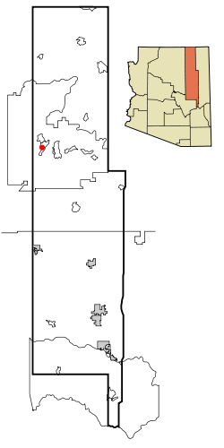
Oraibi, Arizona Location in Navajo County and the state of Arizona Country United States State Arizona Counties Navajo Elevation 5,679 ft (1,731 m) Time zone MST (UTC-7) Oraibi, also referred to as Old Oraibi, is a Hopi village in Navajo County, Arizona, United States, in the northeastern part of the state. Known as Orayvi by the native inhabitants, it is located on Third Mesa on the Hopi Reservation near Kykotsmovi Village. There are no accurate census counts or estimates for the village population.
Contents
History
Oraibi was founded sometime before the year 1100 AD, making it one of the oldest continuously inhabited settlements within the United States.[1][2] Archeologists speculate that a series of severe droughts in the late 13th century forced the Hopi to abandon several smaller villages in the region and consolidate within a few population centers. As Oraibi was one of these surviving settlements its population grew considerably, and became populous and the most influential of the Hopi settlements. By 1890 the village was estimated to have a population of 905, almost half of the 1,824 estimated to be living in all of the Hopi settlements at the time.[3]
Oraibi remained unknown to European explorers until about 1540 when Spanish explorer Don Pedro de Tovar (who was part of the Coronado expedition) encountered the Hopi while searching for the legendary Seven Cities of Gold. Contact with the Europeans remained scant until 1629 when the San Francisco mission was established in the village.[4] In 1680 the Pueblo Revolt resulted in decreased Spanish influence in the area and the cessation of the mission.[5] Subsequent attempts to reestablish the missions in Hopi villages were met with repeated failures. The former mission is still visible today as a ruin.[6]
The Oraibi split
Hopi interaction with outsiders slowly increased during the 1850–1860 time period through missionaries, traders and surveyors for the US government. Contact remained sporadic and informal until 1870 when an Indian agent was appointed to the Hopi, followed by the establishment of the Hopi Indian Agency in Keams Canyon in 1874.
Interaction with the US government increased with the establishment of the Hopi reservation in 1882. This led to a number of changes for the Hopi way of life. Missionary efforts intensified and Hopi children were kidnapped from their homes and forced to attend school, exposing them to new cultural influences.[7]
In 1890 a number of residents more receptive to the cultural influences moved closer to the trading post to establish Kykotsmovi Village, sometimes called New Oraibi. The continuing tension caused by the ideological schism between the "friendlies" ("New Hopi" to the traditional Hopi), those who were open to these cultural influences, and the "hostiles" (or "Traditionalists" led by Yukiuma) who opposed them (those who desired to preserve Hopi ways)[8] led to an event called the Oraibi Split in 1906. Tribal leaders on differing sides of the schism engaged in a bloodless competition to determine the outcome,[9] which resulted in the expulsion of the hostiles (Traditionalists), who left to found the village of Hotevilla. Subsequent efforts by the displaced residents to reintegrate resulted in an additional split, with the second group founding Bacavi.
With the loss of much of its population Oraibi lost its place as the center of Hopi culture. Although the Hopi tribal constitution, maneuvered into being by the Coal Mining Interests in 1939, provides each village with a seat on the tribal council, Hotevilla, where most of the traditional Hopi settled, has declined to elect a representative and maintains independence from the tribal council. Kykotsmovi Village is now the seat of the Hopi tribal government.
Oraibi today
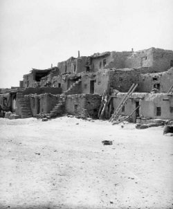
Old Oraibi Oraibi village, circa 1899
Built: 1150 NRHP Reference#: 66000188 Significant dates Added to NRHP: October 15, 1966[10] Designated NHL: July 19, 1964[11] In spite of the "friendly" ("New Hopi") outcome of the Oraibi Split, Old Oraibi has since maintained a more traditional Hopi way of life and has resisted the adoption of the more modern culture visible in Kykotsmovi. While visitors to the pueblo are welcomed, the residents tend to be very private and do not allow photographs to be taken in the town, and thus there are no reliable photographs of the settlement as it exists in the modern day.
Old Oraibi is listed on the National Register of Historic Places and was declared a National Historic Landmark in 1964.[11][12][13]
Cultural references
Oraibi features prominently in a famous writing by Aby Warburg, "Das Schlangenritual. Ein Reisebericht. Mit einem Nachwort von Ulrich Raulff. Berlin 1988", which is the transcript of a conference given in Kreuzlingen, Switzerland in 1923 (English translation in the book "Images from the Region of the Pueblo Indians of North America"; also translated in many other languages). Warburg visited Oraibi in 1896 and with the help of Henry Voth attended a ritual spring dance of the Hopi. He found in the symbolism of the Hopi (in particular the snake symbol) a key to understanding similar symbols in other cultures. Warburg took several pictures of Oraibi and of the Hopi ceremonies.
Hopi life in Oraibi is also described in Don C. Talayesva autobiography, "Sun chief, the autobiography of a Hopi Indian". Don C. Talayesva was born in Oraibi in 1890, where he was raised as a traditional Hopi. Talayesva started working in 1938 with Yale University anthropologist, Leo Simmons, who helped him write his autobiography.
References
- ^ "Hopi Places". Cline Library, Northern Arizona University. http://library.nau.edu/speccoll/exhibits/indigenous_voices/hopi/places.html.
- ^ Casey, Robert L. Journey to the High Southwest. Guilford, CT: Globe Pequot Press, 2007: 382. ISBN 978-0762740642.
- ^ Mooney, James (1928). The Aboriginal Population of America North of Mexico. Smithsonian Institutional Press.
- ^ "Oraibi". Britannica Concise Online. http://www.britannica.com/ebc/article-9057251.
- ^ "Hopi Indians". Catholic Encyclopedia. http://www.newadvent.org/cathen/07468a.htm.
- ^ "The Hopi Reservation - Regions in Brief". http://www.frommers.com/destinations/thehopireservation/1935010043.html.
- ^ "The Hopi Tribe". The Hopi Tribe. http://www.hopi.nsn.us/history.asp.
- ^ "Hopi History and Cultural Relations". World Culture Encyclopedia. http://www.everyculture.com/North-America/Hopi-History-and-Cultural-Relations.html.
- ^ "Hopi Country". Moon Handbooks. http://www.arizonahandbook.com/hopi.htm.
- ^ "National Register Information System". National Register of Historic Places. National Park Service. 2007-01-23. http://nrhp.focus.nps.gov/natreg/docs/All_Data.html.
- ^ a b "Old Oraibi". National Historic Landmark summary listing. National Park Service. http://tps.cr.nps.gov/nhl/detail.cfm?ResourceId=100&ResourceType=District. Retrieved 2007-09-27.
- ^ ["Old Oraibi", October 9, 1975, by Francine WeissPDF (558 KiB) "National Register of Historic Places Inventory-Nomination"]. National Park Service. 19. "Old Oraibi", October 9, 1975, by Francine WeissPDF (558 KiB).
- ^ [Old Oraibi--Accompanying photos, exterior and interior, from 19.PDF (479 KiB) "National Register of Historic Places Inventory-Nomination"]. National Park Service. 19. Old Oraibi--Accompanying photos, exterior and interior, from 19.PDF (479 KiB).
Thompson, Laura; Alice Joseph (1945, 1965). The Hopi Way. New York: Russell & Russell. pp. 12, 29, 30.
Coordinates: 35°52′35″N 110°38′25″W / 35.87639°N 110.64028°W
Municipalities and communities of Navajo County, Arizona County seat: Holbrook Cities Towns CDPs Chilchinbito | Cibecue | Dilkon | East Fork | First Mesa | Greasewood | Heber-Overgaard | Hotevilla-Bacavi | Jeddito | Kayenta | Keams Canyon | Kykotsmovi Village | McNary‡ | Oljato-Monument Valley | Pinon | Second Mesa | Shongopovi | Shonto | Whiteriver | Winslow West‡
Unincorporated
communitiesClay Springs | Fort Apache | Indian Wells | Joseph City | Linden | Oraibi | Pinedale | Polacca | Sun Valley | White Mountain Lakes Estates | Woodruff
Ghost towns Brigham City | Sunset
Footnotes ‡This populated place also has portions in an adjacent county or counties
Categories:- Unincorporated communities in Navajo County, Arizona
- Hopi tribe
- Pueblo great houses
- Native American history of Arizona
- National Historic Landmarks in Arizona
- 1150s architecture
Wikimedia Foundation. 2010.


