- Arizona State Route 264
Infobox road
marker_
state=AZ
highway_name=
name_notes=
type=state
route=264
alternate_name=
maint=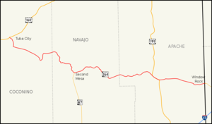
length_mi=154.35
length_round=2
length_ref=cite web |url=http://tpd.az.gov/data/reports/2006SHSLog.pdf |title=2006 ADOT Highway Log |author=Arizona Department of Transportation |accessdate=2008-04-08]
length_notes=
established=
decommissioned=
direction_a=West
starting_terminus=jct|state=AZ|US|160 in Tuba City
junction=jct|state=AZ|US|191 near Ganado
direction_b=East
ending_terminus=jct|state=NM|NM|264 near Window Rock
previous_type=AZ
previous_route=261
next_type=AZ
next_route=266
commons=State Route 264 (SR 264) is a highway in northeastern
Arizona that runs from its junction with US 160 in Tuba City to the border withNew Mexico . The roadway is still numbered 264 into New Mexico to its junction with US 491.Route description
The western terminus of SR 264 is located at a junction with US 160 in Tuba City. The highway heads towards the southeast and then south from this junction until it reaches BIA Route 6710. At this junction, SR 264 begins to heads towards the southeast. It continues on this heading until it curves towards the south southeast of Coal Mine Mesa. The highway curves back towards the east and then north as it follows the terrain of the area. The highway curves back towards the east just prior to an intersection with BIA Route 6660. It continues towards the east to a junction with BIA Route 62 where SR 264 curves towards the southeast. The highway curves towards the south just prior to passing through Hotevilla. It curves back towards the east when it reaches Old Oraibi. The highway curves back towards the south until it reaches the northern terminus of SR 87 in Second Mesa. From here, it heads east, passing through Polacca and Keams Canyon. SR 264 continues to the southeast until it curves back toward the east at an intersection with BIA Route 6. SR 264 continues east to a junction with US 191 in Burnside and the two run concurrently until they reach Ganado. US 191 heads south from this junction as SR 264 heads east. SR 264 continues east to Window Rock just prior to crossing the
New Mexico border and continuing asNew Mexico State Route 264 .cite map|publisher=Google Maps |title=Overview map of SR 264|accessdate=2008-04-17|url=http://maps.google.com/maps?f=d&hl=en&geocode=574411929907009191,36.119140,-111.228990%3B3580677809089492390,35.662457,-109.046754&saddr=AZ-264+%4036.119140,+-111.228990&daddr=AZ-264+%4035.662457,+-109.046754&doflg=ptm&jsv=107&sll=35.88713,-110.13787&sspn=1.533131,2.559814&ie=UTF8&z=9]SR 264 is one of two major east-west routes crossing the expansive
Navajo Indian Reservation , the other being US 160. It also bisects theHopi Reservation . Much of this territory is sparsely inhabited and is home to wide open, scenic vistas. While it does not pass through any large cities or towns, it does pass through Window Rock, seat of government for theNavajo Nation , as well as nearOld Oraibi , which is generally considered the oldest continuously inhabited settlement in North America.History
Although SR 264 became a state highway in 1961, [cite web|author=Arizona Department of Transportation|url=http://www.azhighwaydata.com/resolutions/?resnum=1961-%20-017|title=ADOT Right-of-Way Resolution 1961-017|accessdate=2008-05-12] maps of the area would indicate that the route itself has existed as a dirt road as early as 1927. [cite map|publisher=
Rand McNally |url=http://www.arizonaroads.com/maps/index.html|title=Auto Road Map of Arizona and New Mexico|year=1927|accessdate=2008-05-12] By 1935, portions of the route had been improved. The section between Oraibi and Keams Canyon and the section from northwest of Ganado and the New Mexico border had been improved for travel. [cite map|publisher=Arizona State Highway Department|url=http://www.arizonaroads.com/maps/index.html|title=Road Map of Arizona|year=1935|accessdate=2008-05-12] By 1938, the route had been improved further to a gravel road. [cite map|publisher=Rand McNally|url=http://www.arizonaroads.com/maps/index.html|title=Road Map of Arizona and New Mexico|year=1938|accessdate=2008-05-12] By the time the route became a state highway in 1961, the route had been paved. [cite map|publisher=Rand McNally|url=http://www.arizonaroads.com/maps/index.html|title=Road Map of Arizona|year=1961|accessdate=2008-05-12]Junction list
External links
* [http://www.arizonaroads.com/arizona/az264.html AZ 264 at Arizona Roads]
References

Wikimedia Foundation. 2010.