- Holbrook, Arizona
Infobox Settlement
official_name = Holbrook, Arizona
settlement_type =City 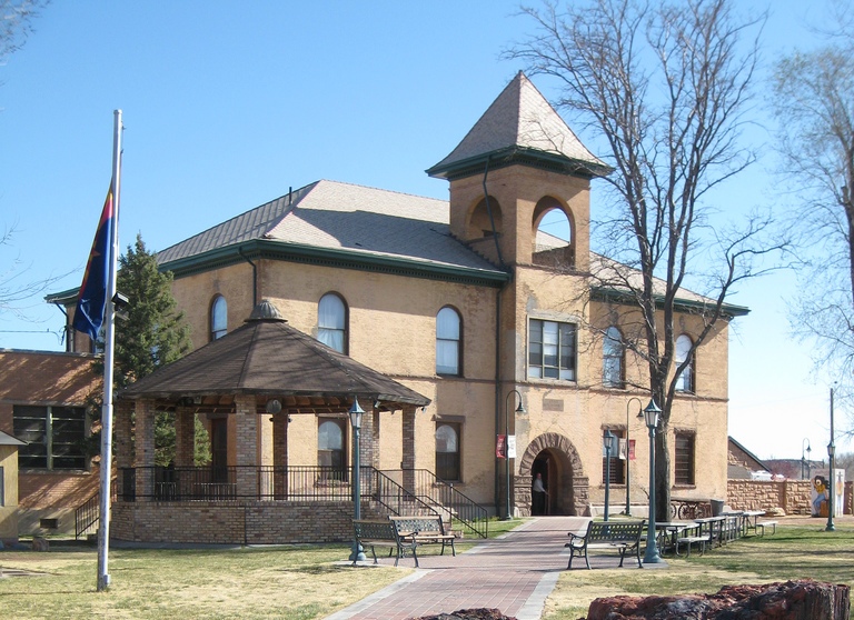
imagesize =
image_caption = Historic Navajo County Courthouse and Museum
image_
mapsize = 250px
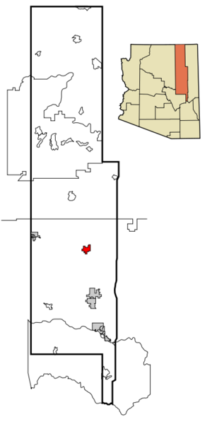
map_caption = Location inNavajo County and the state ofArizona
mapsize1 =
map_caption1 =
subdivision_type = Country
subdivision_type1 = State
subdivision_type2 = County
subdivision_name =United States
subdivision_name1 =Arizona
subdivision_name2 = Navajo
government_type =
leader_title = Mayor
leader_name = Bryan Smithson
established_date =
area_magnitude =
area_total_km2 = 39.9
area_total_sq_mi = 15.4
area_land_km2 = 40.0
area_land_sq_mi = 15.4
area_water_km2 = 0.0
area_water_sq_mi = 0.0
elevation_ft = 5083
elevation_m = 1549
population_as_of = 2007
population_footnotes =cite web|url=http://www.census.gov/popest/cities/tables/SUB-EST2007-04-04.csv|title=Annual Estimates of the Population for Incorporated Places in Arizona|publisher=United States Census Bureau |date=2008-07-10|accessdate=2008-07-14]
population_total = 5091
population_metro =
population_density_km2 = 122.9
population_density_sq_mi = 318.4
timezone = MST
utc_offset = -7
latd = 34 |latm = 54 |lats = 26 |latNS = N
longd = 110 |longm = 9 |longs = 46 |longEW = W
timezone_DST =
utc_offset_DST =
postal_code_type =ZIP code
postal_code = 86025
area_code = 928
GNIS_id = 5871
blank_name = FIPS code
blank_info = 04-33280
blank1_name =
blank1_info =
footnotes =
website =Holbrook ( _nv. Tʼiisyaakin) is a city in Navajo County,
Arizona ,United States . According to 2006 Census Bureau estimates, the population of the city was 5,126.cite web | date =June 21 2006 | url = http://www.census.gov/popest/cities/tables/SUB-EST2005-04-04.csv | title = Annual Estimates of the Population for All Incorporated Places in Arizona | format = CSV | work = 2005 Population Estimates | publisher = U.S. Census Bureau, Population Division | accessdate = November 15 | accessyear = 2006] The city is thecounty seat of Navajo CountyGR|6.Holbrook was founded in 1881 or 1882, when the railroad was built, and named to honor the first chief engineer of the
Atlantic and Pacific Railroad . [http://www.azcommerce.com/doclib/commune/holbrook.pdf]Geography
Holbrook is located at coor dms|34|54|26|N|110|9|46|W|city (34.907203, -110.162882)GR|1.
According to the
United States Census Bureau , the city has a total area of 15.4square mile s (40.0km² ), all of it land.Historical events
*During 1881 & 1882, railroad tracks were laid down and a railroad station was built. The community was then named Holbrook after the first engineer of the
Atlantic and Pacific Railroad .*Holbrook became the county seat of Navajo County in 1895 and was incorporated in 1917.
*Many of the events that played out during the
Pleasant Valley War up to 1887 occurred in and around Holbrook.Holbrook meteorite
A meteorite with an estimated mass of 190 kg exploded over the town of Holbrook on
July 19 ,1912 .Demographics
As of the
census GR|2 of 2000, there were 4,917 people, 1,626 households, and 1,195 families residing in the city. Thepopulation density was 318.4 people per square mile (122.9/km²). There were 1,906 housing units at an average density of 123.4/sq mi (47.6/km²). The racial makeup of the city was 59.28% White, 24.00% Native American, 2.36% Black or African American, 1.04% Asian, 8.38% from other races, and 4.94% from two or more races. 23.35% of the population were Hispanic or Latino of any race.There were 1,626 households out of which 40.7% had children under the age of 18 living with them, 52.3% were married couples living together, 16.4% had a female householder with no husband present, and 26.5% were non-families. 22.6% of all households were made up of individuals and 6.8% had someone living alone who was 65 years of age or older. The average household size was 2.93 and the average family size was 3.47.
In the city the population was spread out with 35.7% under the age of 18, 9.3% from 18 to 24, 26.5% from 25 to 44, 19.8% from 45 to 64, and 8.7% who were 65 years of age or older. The median age was 30 years. For every 100 females there were 90.2 males. For every 100 females age 18 and over, there were 87.7 males.
The median income for a household in the city was $31,746, and the median income for a family was $36,349. Males had a median income of $30,797 versus $24,088 for females. The
per capita income for the city was $13,912. About 16.6% of families and 20.1% of the population were below thepoverty line , including 25.7% of those under age 18 and 3.2% of those age 65 or over.Points of interest
*
Petrified Forest National Park is located 28 miles east of Holbrook, the nearest city to the park.*The Historic Navajo County Courthouse and Museum in Downtown Holbrook. Built in 1898, the courthouse is now home to the Navajo County Historical Society and is listed on the
National Register of Historic Places .
*Wigwam Motel on Hopi Drive. Built in 1950, is listed in theNational Register of Historic Places as Wigwam Village #6.
*HistoricU.S. Route 66 runs through Holbrook.Education
The city is served by the
Holbrook Unified School District and serves 2324 students.Two elementary Schools, Park Elementary School (K-2) and Hulet Elementary School (3-5) serve the city. Holbrook Junior High School (6-8) and Holbrook High School (9-12) serve the city.
References
External links
* [http://www.ci.holbrook.az.us/ City of Holbrook]
* [http://www.azcommerce.com/doclib/commune/holbrook.pdf Holbrook community profile] fromArizona Department of Commerce
Wikimedia Foundation. 2010.