- Arizona State Route 277
Infobox road
marker_
state=AZ
highway_name=
name_notes=
type=state
route=277
alternate_name=
maint=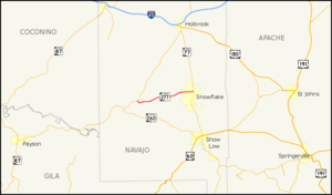
length_mi=30.66
length_round=2
length_ref=cite web |url=http://tpd.az.gov/data/reports/2006SHSLog.pdf |title=2006 ADOT Highway Log |author=Arizona Department of Transportation |accessdate=2008-04-08]
length_notes=
established=
decommissioned=
direction_a=West
starting_terminus=jct|state=AZ|SR|260 near Heber
junction=
direction_b=East
ending_terminus=jct|state=AZ|SR|77 in Snowflake
previous_type=AZ
previous_route=273
next_type=AZ
next_route=279
commons=State Route 277 (SR 277) is a highway in
Navajo County, Arizona that runs from its junction with SR 260 in Heber to its junction with SR 377 in Snowflake. It is an east-west route.Route description
SR 277 is a convert|30.66|mi|km|2|sing=on highway that provides a direct route connecting Heber and Snowflake. It does not pass through any other cities or towns. The western terminus is located at an intersection with SR 260 east of Heber. The highway heads northeast from this intersection and curves towards the east prior to an intersection with SR 377. SR 377 heads northeast to Holbrook while SR 377 continues to the east. It heads east to an intersection with a spur route that provides access to a paper mill. SR 277 heads northeast from this junction and curves back towards the east as it enter the Snowflake city limits. The highway reaches its eastern terminus at an intersection sith SR 77 in Snowflake. [cite map|publisher=
Google Maps |title=Overview map of SR 277|accessdate=2008-04-15|url=http://maps.google.com/maps?f=d&hl=en&geocode=2913634420760977242,34.417320,-110.574850%3B16904946362439029001,34.513310,-110.080590&saddr=AZ-277+%4034.417320,+-110.574850&daddr=AZ-277+%4034.513310,+-110.080590&doflg=ptm&jsv=107&sll=34.46539,-110.32772&sspn=0.721223,0.75531&ie=UTF8&z=10]Junction list
The entire route is in Navajo County.
References

Wikimedia Foundation. 2010.