- Navajo National Monument
-
Navajo National Monument IUCN Category III (Natural Monument)
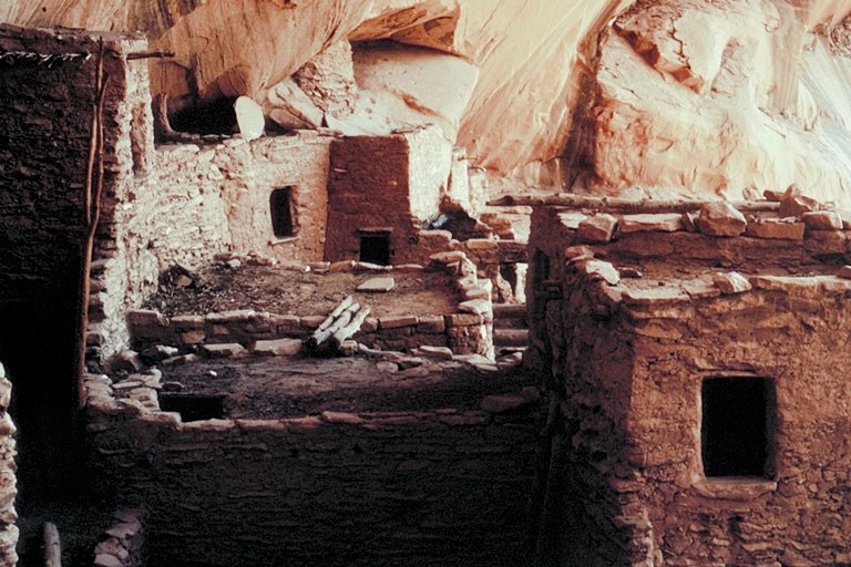
Keet Seel cliff dwellings

Location Navajo & Coconino counties, Arizona, USA Nearest city Kayenta, Arizona Coordinates 36°40′42″N 110°32′27″W / 36.6783318°N 110.5409720°WCoordinates: 36°40′42″N 110°32′27″W / 36.6783318°N 110.5409720°W[1] Area 360 acres (146 ha) [2] Established March 20, 1909 Visitors 77,901 (in 2009)[3] Governing body National Park Service Navajo National Monument is located within the northwest portion of the Navajo Reservation in northern Arizona.
Navajo National Monument preserves three of the most intact cliff dwellings of the ancestral puebloan people (Hisatsinom). The Navajo people who live here today call these ancient ones Anasazi. The monument is high on the Shonto plateau, overlooking the Tsegi Canyon system in the Navajo Nation in northern Arizona. The monument, located west of Kayenta, Arizona, features a visitor center with a museum, two short self-guided mesa top trails, two small campgrounds, and a picnic area. Rangers guide visitors on free tours of the Keet Seel (Kitsʼiil) and Betatakin (Bitátʼahkin) cliff dwellings. The Inscription House site (Tsʼah Biiʼ Kin), further west, is currently closed to public access.
The Sandal Trail is an accessible self-guided walk that provides views of the spectacular canyonlands and rugged topography near the visitor center. Interpretive signs provide information on local flora and other topics. The 1.6 km round-trip trail ends at an overlook of the Betatakin ruins across the 560 feet (170 m) deep Betatakin Canyon. The National Monument was listed on the National Register of Historic Places on October 15, 1966.[4]
Contents
Kiet Siel
Kiet Siel (Kįtsʼiil, commonly spelled Keet Seel), which stands for "broken house" in Navajo, is a well preserved cliff dwelling of the ancient Anasazi people located in a branch of the Tsegi Canyon in the Kayenta region of Northeastern Arizona. The site was first occupied at around AD 1250, during a time in which a large number of people were believed to be aggregating in sites such as this in this part of the American Southwest. There was a construction boom at Kiet Siel between AD 1272 and 1275, with construction then slowly tapering off and halting completely at AD 1286. Once construction halted in AD 1286, there was no evidence of structures being built until its subsequent abandonment some 20 years later. At its peak, its believed that up to 150 people inhabited this site at one time. Kiet Siel, along with Betatakin and Tsʼah Biiʼ Kin (Inscription House), are the three cliff dwelling sites that make up the now protected Navajo National Monument. These three sites were declared a national monument in 1909. Due to the extremely dry climate and natural overhanging cliff, the conditions at Kiet Siel were quite optimal[citation needed] for excellent preservation of the site's dwellings and artifacts. Kiet Siel is considered by many archaeological experts[5] to be one of the best preserved larger ruins in the American Southwest.
Betatakin
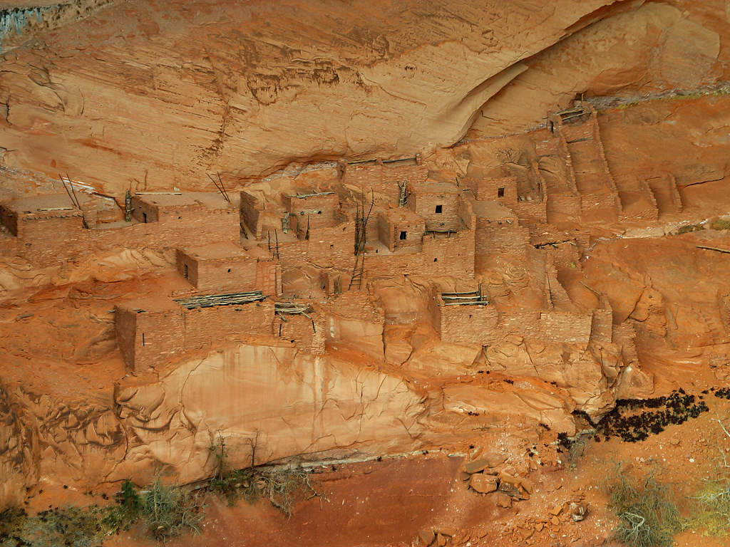
Betatakin means "House Built on a Ledge" in Navajo. In Hopi, the name of the place is Talastima, or "Place of the Corn Tassel". Betatakin is smaller than nearby Kiet Siel, with about 120 rooms at the time of abandonment. However, like Keet Seel, Betatakin was constructed of sandstone, mud mortar, and wood. Today only about 80 rooms remain, due to rock falls inside the alcove. Betatakin only has one kiva,[5] whereas Kiet Siel has several. Betatakin was built in an enormous alcove measuring 452 feet high and 370 feet across between 1267 and 1286[6] The first excavations occurred in 1917 under Neil Judd, and continued into the 1950s and 1960s under archaeologists like Jeffery Dean.[5] During its two-decade heyday Dean estimated a maximum population of about 125 people.
Discovery
The site of Kiet Siel was "discovered" in 1895 by the Wetherill Brothers. Originally part of a ranching family from Colorado, the Wetherill's keen interest in the Ancient Anasazi led them to pursue numerous expeditions into the heart of the Kayenta region, largely uncovering a number of sites that had remained undiscovered until then. Richard Wetherill is credited for selecting the term Anasazi, which refers to the ancient people that inhabited this region and means "Enemy Ancestors" in Navajo. It was not until 1909, after Navajo National Monument was created, that John Wetherill and Navajo guide Clatsozen Benully "discovered" Betatakin. The Weatherill Brothers made a living from giving guided tours of sites in and around the Tsegi Canyon and Utah. Later in their careers, the Weatherill brothers were largely involved in efforts for the preservation and protection of the sites that made up Navajo National Monument.
Subsistence
The Anasazi of this area were a sedentary group that largely based their subsistence on agriculture. Their primary crop at the sites within Navajo National Monument was maize, with beans and cucurbits also being incorporated into their diet. While the people of the Tsegi Canyon system relied heavily on agriculture for their food, they also hunted wild game that was indigenous to the area.
It is thought that these Anasazi people lived in these cave dwellings to optimize the amount of sustainable land to produce crops. By living in these caves, and not on the mesas or the canyon floors, they were able to use this land towards agricultural production to ensure their success in this high elevation, desert environment. The ruins that make up Navajo National Monument were a large number of rooms used for storage, suggesting that at some point their crop production was successful enough to dedicate a significant amount of their living area towards storage purposes.
Dwellings/ Architecture
 Betatakin ruins in Betatakin Canyon.
The structures contained within this cave site were constructed mainly of sandstone blocks plastered together with mud and mortar. In marked contrast to earlier constructions and villages on top of the mesas, the cliff dwelling of Navajo National Monument reflected a region-wide trend towards the aggregation of growing regional populations into close, highly defensible quarters during the mid to late 13th century.
While much of the construction in this site remains similar to common ancestral Pueblo architectural forms, including such features as Kivas, a circular tower (at Kiet Siel), and pit-houses, the limited space that this site presented created a much more densely populated living area. At its peak, Kiet Siel had more than 150 rooms and 6 kivas, while Betatakin had about 120 rooms and only one kiva.[5]
Jacal walls were also found to be used at this site. Jacal walls were made from a screen of upright wooden poles plastered together with mud. The dry conditions and protection from the elements at Kiet Siel allowed for some of the most notable preservation of these architectural characteristics in all of the Southwest[citation needed].
There were also a number of structures believed to be built at the base of the cliff as well. But due to this area not being protected by the over-hanging cliff wall, its exposure to the elements led to its destruction by erosion. At Kiet Siel, archaeological excavations have revealed that there were 25 room clusters beneath the overhanging wall, each that included 1 common living room, with anywhere from 1 to 4 storage rooms surrounding a small courtyard. The layout of these dwellings greatly mirrored that of the Pueblo III structures at Mesa Verde, whereas Betatakin had about 20 room clusters.
Abandonment
Although many archaeologists agree that there is a definitive and sharp exodus from this region in the Southwest, there has been considerable debate on the determining factors that forced people to migrate out of this area. Archaeologists have determined that there was a distinct decrease in the amount of annual precipitation between AD 1276 and 1299, a period of time that is now referred to as the "Great Drought". With the limited amount of rainfall in an already arid environment, there is no doubt that there was a considerable amount of increased stress put on the agricultural systems that these people depended on.
There is evidence later in the record to suggest the beginning of an episode of deep arroyo cutting, that would have damaged what was left of the usable agricultural land. Increased deposition of sediment onto agricultural lands caused the lowering of the water table, thus making the land inadequate for farming. Regardless of their reasoning, near the end of the thirteenth century its evident that the Anasazi people migrated towards places with more stable and abundant water sources, suggesting that the agricultural land in this area had become unsuitable to sustain the population levels that once inhabited this spectacular cave site.
Hopi legends tell a different tale. According to oral tradition, the area known as Wunuqa (modern day Tsegi Canyon)[5] was abandoned as part of a spiritual quest.[5][7] In particular, the Snake Clan inhabited the Navajo National Monument ruins, along with the Horn Clan. The Horn Clan forced the Snake Clan out, due to the children of the Snake Clan biting other children and causing death.[7] This may be an allegory for some historical occurrence, in which one group forced another out for a perceived fault or slight.
See also
References
- ^ "Navajo National Monument". Geographic Names Information System, U.S. Geological Survey. http://geonames.usgs.gov/pls/gnispublic/f?p=gnispq:3:::NO::P3_FID:23407. Retrieved 2011-08-28.
- ^ "Listing of acreage as of 12/31/2010". Public Use Statistic Office, National Park Service. http://www.nature.nps.gov/stats/Acreage/acrebypark10cy.pdf.
- ^ "Five Year Annual Recreation Visits Report". Public Use Statistic Office, National Park Service. http://www.nature.nps.gov/stats/viewReport.cfm?selectedReport=SystemComparisonReport.cfm.
- ^ "National Register Information System". National Register of Historic Places. National Park Service. 2009-03-13. http://nrhp.focus.nps.gov/natreg/docs/All_Data.html.
- ^ a b c d e f Roberts, David. 1996. In Search of the Old Ones: Exploring the Anasazi World of the Southwest. Touchstone Press. pp. 271
- ^ Dean, Jeffrey. 1969. Chronological analysis of Tsegi Phase sites in Northeastern Arizona. Tucson.
- ^ a b Courlander, Harold. 1971. The Fourth World of the Hopis: the epic story of the Hopi Indians as preserved in their legends and traditions.pp. 239. University of New Mexico Press.
Related Readings
- Doyel, David E. & Dean, Jeffrey S. "Environmental Change and Human Adaptation in the Ancient American Southwest". The University of Utah Press, Salt Lake City. 1996
- Ferguson W.M. & Rohn A.H. "Anasazi Ruins of the Southwest in Color". The University of New Mexico Press, Albuquerque. 1999
- Noble, David Grant. "Houses Beneath the Rock: The Anasazi of Canyon de Chelly and Navajo National Monument". Ancient City Press, Sante Fe, New Mexico. 1986
- Plog, Stephen. "Ancient Peoples of the American Southwest". Thames & Hudson Inc., 500 Fifth Avenue, New York, New York 10110. 1997
- Rothman, Hal. "Navajo National Monument: A Place and Its People". Southwest Cultural Resources Center. Santa Fe, New Mexico. Professional Papers No. 40, 1991
External links
 Media related to Navajo National Monument at Wikimedia Commons
- Official NPS website: Navajo National Monument
- Betatakin Photo Gallery
- American Southwest, a National Park Service Discover Our Shared Heritage Travel Itinerary
- NPS website on Navajo National Monument, http://www.nps.gov/nava/historyculture/index.htm
Protected Areas of Arizona Federal Canyon de Chelly · Casa Grande Ruins · Chiricahua · Grand Canyon-Parashant · Hohokam Pima · Montezuma Castle · Navajo National Monument · Organ Pipe Cactus · Pipe Spring · Sunset Crater · Tonto · Tuzigoot · Walnut Canyon · WupatkiGila Box Riparian · Las Cienegas · San Pedro RiparianArizona National Scenic Trail · Juan Bautista de Anza National Historic Trail · Old Spanish National Historic TrailBill Williams River · Buenos Aires · Cabeza Prieta · Cibola · Havasu · Imperial · Kofa · Leslie Canyon · San BernardinoOtherCoronado National Memorial · Elden Pueblo · Glen Canyon National Recreation Area · Lake Mead National Recreation Area · Palatki Heritage Site · V-Bar-V Heritage SiteState Western RegionAlamo Lake · Buckskin Mountain · Cattail Cove · Lake Havasu · River Island · Yuma Quartermaster Depot · Yuma Territorial PrisonNorthern RegionDead Horse Ranch · Fort Verde · Homolovi · Jerome · Red Rock · Riordan Mansion · Slide Rock · Verde River GreenwayEastern RegionBoyce Thompson Arboretum · Catalina · Fool Hollow Lake · Lost Dutchman · Lyman Lake · McFarland · Oracle · Tonto Natural BridgeSouthern RegionKartchner Caverns · Patagonia Lake · Picacho Peak · Roper Lake · San Rafael · Sonoita Creek · Tombstone Courthouse · Tubac PresidioMunicipal Other See List of National Natural Landmarks in ArizonaArizona State Parks (web) U.S. National Register of Historic Places Topics Lists by states Alabama • Alaska • Arizona • Arkansas • California • Colorado • Connecticut • Delaware • Florida • Georgia • Hawaii • Idaho • Illinois • Indiana • Iowa • Kansas • Kentucky • Louisiana • Maine • Maryland • Massachusetts • Michigan • Minnesota • Mississippi • Missouri • Montana • Nebraska • Nevada • New Hampshire • New Jersey • New Mexico • New York • North Carolina • North Dakota • Ohio • Oklahoma • Oregon • Pennsylvania • Rhode Island • South Carolina • South Dakota • Tennessee • Texas • Utah • Vermont • Virginia • Washington • West Virginia • Wisconsin • WyomingLists by territories Lists by associated states Other  Category:National Register of Historic Places •
  Portal:National Register of Historic Places
United States Ancient Pueblo dwellings in Arizona - Ancient Pueblo dwellings in Colorado - Ancient Pueblo dwellings in New Mexico - Ancient Pueblo dwellings in Utah - Ancient Pueblo dwellings in Texas - Ancient Pueblo dwellings in NevadaMexico Ancient Pueblo dwellings in Chihuahua - Ancient Pueblo dwellings in Sonora - Huápoca - Cuarenta CasasAfrica Asia Categories:- IUCN Category III
- Native American history of Arizona
- National Park Service National Monuments in Arizona
- Protected areas of Coconino County, Arizona
- Protected areas of Navajo County, Arizona
- Protected areas established in 1909
- Museums in Navajo County, Arizona
- Archaeology museums in Arizona
- Native American museums in Arizona
- Archaeological sites in Arizona
- Landmarks in Arizona
- Archaeological sites on the National Register of Historic Places in Arizona
- Native American archeology
- Geography of the Navajo Nation
- Oasisamerica cultures
- Pre-Columbian cultural areas
- Ruins in the United States
- Cliff dwellings


Wikimedia Foundation. 2010.